

-
Welcome to Simtropolis!
A community dedicated to SimCity 4 and all city-building games. (About Simtropolis)
-
Announcement
-

Simtropolis Returns! 05/26/2026
See here for details about our site recovery efforts.
-
 Supported
City Journals
Our community City Journals
-
 Latest Entry
Update 2: The Redeux
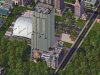
Wow, it's been about 10 months since I posted here. Too long... But never fear! I have recently been downloading custom content that caught my eye, and have compiled a fairly large basket of content. Today, I only have a teaser, but I hope this gives your some ideas about what I'll be doing in the future. It is a fairly new style, it's not Greek like the first update, but rather.... just me. I just built what I was yearning to build, and I hope you enjoy my the way it turned out. I encourage you to click the link for the full resolution picture in the new window.... it looks sooo much better. Click for linky to big resolution! I'd really like to thank everyone who's followed one of CJs, and I hope to make more of a permanent return to the CJ world. DC -
- 5
Entries - 7
Comments - 2966
Views
Recent Entries
- 5
-
- 3
Entries - 7
Comments - 3981
Views
Recent Entries
 Latest Entry
Part 3: Destruction and Division 1940-1989
When the war started everyday life in Berlin changed Drastically. citizens no longer engaged in unneeded shopping or entertainment. And so it was that Potsdamer Platz began its long decline. beginning in 1943 allied air raids over Berlin leveled whole blocks of city and set many buildings on fire. From February 1944 to may 1945 over 50 bombing raids over the city were carried out by the RAF and the US air force. Potsdamer Platz was an obvious target for these raids and thus the square suffered heavily. When Soviet Troops entered the square in late April 1945 they found it in ruins. Almost 80% of the buildings in and around the square were destroyed. After the war Berlin was split into occupation zones by the victorious allies. Potsdamer Platz lay directly between the American and Soviet occupation zones. Most of the rubble from the war was taken away in the early 1950's and potsdamer platz was paved over. In 1961 the Infamous Berlin Wall was built right down the middle of Potsdamer Platz. this turned the square into a desolate no-mans land for 26 years. by 1975 Potsdamer platz has ceased to exist. it was now just a barren waste land between the two Berlins. More to come!!! - 3
-
 Latest Entry
Sneak peak of downtown Porterville
This is my first city journal and will take you around the Porterville metropolitan area with each entry, and updates on any new additions I make to areas. Comments are welcome!! Let me know what you think, hope everyone likes it!!! <a href="https://s1080.photobucket.com/albums/j325/johnnybbaby/?action=view&current=Portervillesneak.png" target="_blank"><img src="https://i1080.photobucket.com/albums/j325/johnnybbaby/Portervillesneak.png" border="0" alt="Photobucket"></a> -
 Latest Entry
aqua -journal 1
Hey everyone this is my first journal so forgive me if its small or anything... This is actually version 16 of my city aqua to build it to my liking and i wanted all green roads (road traffic) here's the satalite vieuw of the city before i completly redidt everything. here are some pictures of my blueprints and some other pictures: -
 Latest Entry
.::Sin City ::. v2.0 .: "The Beginning"
Sin City::. Established and Founded in 1788::.. The city here started small but quickly advanced with a population of over 200,000 in just the first few years of becoming a City. Sin City's first establishments consisted of Jail Houses, Police stations, and abandoned buildings which QUICKLY turned this somewhat "good hearted" thought out city, to be fulfilled with the most horrific criminal masterminds of the 17th century, thus receiving the nick-name "Sin City" ------------------------------------------------------------------------------------------------------------------------------------- When the city first began it was called the city of "Cincinnati", after years of "misleaded mayorism" the city was turned over to a new mayor by the name of "Dexter Morgan" :: This young new enthusiastic mayor had high hopes, and BIG plans for Sin City to be turned from a ran down "ghetto" city full of Sinful souls, into a dream city with skyscrapers, businesses, residential homing, and most of all, a City "Full of Life", as New mayor Dextor Morgan stated. When Dexter took over Sin City the first thing he did was build a suspension bridge north, across "Rockytop River" and began the first commercial/ and residential zoning management. Quickly the new city was filled with all a cities basic needs, Hospitals, Schools, Businesses, Fire Departments, Water/Gas/Electric Suppliers, ect... **Meanwhile the city grew, Mayor Dexter began another project to be a major influence in the cities transportation: From the new suspension bridge sprung: "Highway I-75" Which splits off into 4 different directions, and added TWO new ways back across "Rockytop River": One way being another bridge, and the other a 4-Lane Expressway going through the middle of the river between the two bridges connections all 3 sections of Sin City's Land.! Both will be seen eventually, in future Sin City Updates!** ------------------------------------------------------------------------------------------------------------------------------------- After years and years of precise planning and strategy Sin City was beginning to look like a REAL CITY! The images below are a few shots of some of the "local spots" that attract most of the tourist, as well as some nice focal points/ and scenic views of Sin City! Although NOT fully complete, and FAR from an Elite City*: Sin City has come a LONG WAY from starting out as a twisted: Criminal filled Industrial Suite, To a life filled: living city with a population of over 200,000 in just the beginning stages of its growth!! ------------------------------------------------------------------------------------------------------------------------------------- Image#1:Shown Here is a night shot of the Island-Tower Hotel (building to the far left on the Island) and its surroundings. This is the second way across RockyTop River: A 4 Lane Expressway enabling vehicles to go both ways on the expressway. ::*In City Hall there is currently a debate on whether to demolish the surrounding land of the island that connects the insland to the cities: and replace both sides with covered bridges: OR to leave it alone and use the budget money on a different project for the city. ------------------------------------------------------------------------------------------------------------------------------------- Image#2: This next image is another night shot: This time of the northern part of Sin City which(for now) is the cities biggest and busiest part of Sin City. This is known to locals for its mass amount of BIG income buildings that tower the streets of "Downtown Sincy" : (So the locals call it anyway.): In this image, To the LEFT :: You can see the Chrysler GT Buisness Building; The US Bank Building; To The Middle: You can see see I-75 Highway splitting up "Downtown Sincy" and "Avondale" which is where you can see above is the "Staples Center" where a vast amount of entertainment is performed weekly for citizens here in Sin City. From Local motocross: To Monster Truck Jams: Even Professional Wrestling/Boxing Events are held here! **There are far too many buildings to point out and show all of them right now, but the next update will take us a little closer into the Dowtown area as well as some other of the many places to see and visit in Sin City** ------------------------------------------------------------------------------------------------------------------------------------- Image #3: InThis Last image here: We show whats on the southern part of I-75 Highway, which stated in the previous image is better known as "Avondale" This is where MOST of Sin City's sporting events, and entertainment is held for its citizens and local tourist and sports fans! You can see once again the Staples Center, Then to the further up is "Cinergy Field" home of the local MLB team "The Reds"; Then further up you will see "Paul Brown Stadium": Which is home of Sin City's NFL team "The Bengals" ! Also in this picture is a towering hotel which is where a lot of tourist and visitors stay at when they come to Sin City for the weekend, or to attend local entertainments events! This hotel: With 686 rooms and 56 floors is called "The Grand Hyatt Hotel" on top you can see it has an "In roof" pool that gets up to 10ft deep and as well as a bar located at the entrance of the roof~! ------------------------------------------------------------------------------------------------------------------------------------- ------------------------------------------------------------------------------------------------------------------------------------- This concludes the FIRST entry for my newest CJ "Sin City" The mayor here as a TON of plans and a BIG FUTURE planned for this city, so stay tuned for the next update which should be within the next few days! I Hope you enjoyed this entry and Im looking forward to hearing what everyone here at Simtropolis thinks about this New but quickly growing suburban city!! Thanks for tuning in!! -
 Latest Entry
Historia e introducción
A map of Nicoya's pre-Columbian extended dominions. A map of the most important place on earth for Nicoyans, their island homeland (it's actually a map of Tahiti made by "drunkapple" but both Tahiti and Ometepe are very similar, thanks to the map creator for such a work!). The lake and surrounding areas (notice Altagracia at the northern tip of the island). And now, the port of Altagracia. Along with the city's western harbor. That's it for now folks, any questions or clarifications will be addressed on future postings. Enjoy the view! -
- 3
Entries - 5
Comments - 7047
Views
Recent Entries
 Latest Entry
London is Burning
Here is a picture of the burned out and irradiated husk of a city what London used to be. - 3
-
- 16
Entries - 80
Comments - 11473
Views
Recent Entries
 Latest Entry
16. Rip City by Night
16. Rip City by Night Hello again everyone. Sorry its been such a long time since my last post. Lately I've gotten bored of playing on the Portland map, and have created a new map to play on. As such this will be my last update for Rip City. If you want to see the rip city content that never made it to the STEX, or catch a preview of my next region, the Ring of Fire, head on over to simpeg.com. But now for this final update, we take a tour of Downtown Portland by night. 1. South waterfront condos. 2. Outbound on the Sunset Highway. 3. The stadium in the West Bricks Neighborhood. 4. Chinatown's main square. 5. The Japanese Theater. 6. Architectural College and the Palm Max station. 7. Fox tower and associated offices. 8. Cops working late. 9. Courthouse. 10. The Governor's Studio Residences. 11. Made in Oregon. 12. Rain Park and the Bancorp Tower. 13. The Federal Building. 14. Downtown Office Boxes. 15. Congress Center. 16. Hoopin it up at night under the lights. 17. Pioneer Towers Project and the Square. 18. Nothing like a night at Kells. 19. The library let's students study late. 20. Spying down on the apartment complexes. 21. Over the offices. 22. Over the north end. 23. Over chinatown and the central residences. 24. Over the West Bricks. 25. Goodnight from Rip City! And thus Rip City fades into the night. Thanks for all your comments and support everyone. Peace. - 16
-
- 10
Entries - 27
Comments - 4081
Views
Recent Entries
- 10
-
 Latest Entry
Welcome to the Pokemon World
This is my final cj, and it is dedicated to all you Pokemon fans out there. Enjoy and please comment. The large region of the Ancient Pokemon World will someday grow into a strong, beautiful nation. Every story needs a beginning, and for the Pokemon World, it is the huge, and breathtaking region of Rome. Yes, i will be naming these regions after real ancient places. No one yet has discovered these ancient regions yet, for some of these cities are lost. As civilization ventures outward, they will advance into the modern-day world, and edventually meet a secret Pokemon King. I dont have any pictures yet, sorry. The primary objective of my CJ is to construct an ancient world and build it from ancient times, industrial times to modern times. You, as the reader, are a Pokemon in my city. As a Pokemon, please comment to the mayor (me) when I ask for a vote on what to put in my city. However, every mayor has to maintain his powers. I have several Mods installed, including RCIMulti and MoneyTree. I use moneytree because my goal aint to build a city as a challenge, but to build a city for an adventurous storyline in the Pokemon World. I have various STEX buildings I use cause I like to build realistic based cities, and many PEG STEX items as well. Please, just fell free to make comments on what youd like to see and what you would like to be improved. All comments are welcome, as long as they are not nasty and crude. Also, please make comments on what STEX buildings youd suggest I have for my cities, and I might get It if it does please me. Now, before my long (and maybe boring) introduction is over, Id like to introduce you to my cities. Mainly, My cj will have three main characters from the Pokemon Anime. Ancient Egypt: Ancient Egypt was an ancient civilization of Northeastern Africa, concentrated along the lower reaches of the Nile River in what is now the modern country of Egypt. Egyptian civilization coalesced around 3150 BC (according to conventional Egyptian chronology)[1] with the political unification of Upper and Lower Egypt under the first pharaoh.[2] The history of ancient Egypt occurred in a series of stable Kingdoms, separated by periods of relative instability known as Intermediate Periods. The Old Kingdom of the Early Bronze Age, the Middle Kingdom of the Middle Bronze Age and the New Kingdom of the Late Bronze Age. Egypt reached the pinnacle of its power during the New Kingdom, in the Ramesside period, after which it entered a period of slow decline. Egypt was conquered by a succession of foreign powers in this late period. In the aftermath of Alexander the Great's death, one of his generals, Ptolemy Soter, established himself as the new ruler of Egypt. This Ptolemaic Dynasty ruled Egypt until 30 BC, when it fell to the Roman Empire and became a Roman province.[3] The success of ancient Egyptian civilization came partly from its ability to adapt to the conditions of the Nile River Valley. The predictable flooding and controlled irrigation of the fertile valley produced surplus crops, which fueled social development and culture. With resources to spare, the administration sponsored mineral exploitation of the valley and surrounding desert regions, the early development of an independent writing system, the organization of collective construction and agricultural projects, trade with surrounding regions, and a military intended to defeat foreign enemies and assert Egyptian dominance. Motivating and organizing these activities was a bureaucracy of elite scribes, religious leaders, and administrators under the control of a Pharaoh who ensured the cooperation and unity of the Egyptian people in the context of an elaborate system of religious beliefs.[4][5] The many achievements of the ancient Egyptians include the quarrying, surveying and construction techniques that facilitated the building of monumental pyramids, temples, and obelisks; a system of mathematics, a practical and effective system of medicine, irrigation systems and agricultural production techniques, the first known ships,[6] Egyptian faience and glass technology, new forms of literature, and the earliest known peace treaty.[7] Egypt left a lasting legacy. Its art and architecture were widely copied, and its antiquities carried off to far corners of the world. Its monumental ruins have inspired the imaginations of travellers and writers for centuries. A new-found respect for antiquities and excavations in the early modern period led to the scientific investigation of Egyptian civilization and a greater appreciation of its cultural legacy.[8] Ancient Greece: Ancient Greece is the civilization belonging to the period of Greek history lasting from the Archaic period of the 8th to 6th centuries BC to the end of antiquity and beginning of the Early Middle Ages with the rise of the Byzantine era following Justinian I.[1] At the center of this time period is Classical Greece, which flourished during the 5th to 4th centuries BC, at first under Athenian leadership successfully repelling the military threat of Persian invasion. The Athenian Golden Age ends with the defeat of Athens at the hands of Sparta in the Peloponnesian War in 404 BC. Following the conquests of Alexander the Great, Hellenistic civilization flourished from Central Asia to the western end of the Mediterranean Sea. Classical Greek culture had a powerful influence on the Roman Empire, which carried a version of it to many parts of the Mediterranean region and Europe, for which reason Classical Greece is generally considered to be the seminal culture which provided the foundation of Western civilization.[2][3][4] The Roman Empire (Latin: Imperium Romanum) was the post-Republican period of the ancient Roman civilization, characterised by an autocratic form of government and large territorial holdings in Europe and around the Mediterranean.[5] The term is used to describe the Roman state during and after the time of the first emperor, Augustus. This includes from about 44 BC to 1453 AD. The 500-year-old Roman Republic, which preceded it, had been weakened and subverted through several civil wars.[nb 2] Several events are commonly proposed to mark the transition from Republic to Empire, including Julius Caesar's appointment as perpetual dictator (44 BC), the Battle of Actium (2 September 31 BC), and the Roman Senate's granting to Octavian the honorific Augustus (4 January 27 BC).[nb 3] Roman expansion began in the days of the Republic, but the empire reached its greatest extent under Emperor Trajan: during his reign (98 to 117 AD) the Roman Empire controlled approximately 6.5 million km2[6] of land surface. Because of the Empire's vast extent and long endurance, the institutions and culture of Rome had a profound and lasting influence on the development of language, religion, architecture, philosophy, law, and forms of government in the territory it governed, particularly Europe, and by means of European expansionism throughout the modern world. In the late 3rd century AD, Diocletian established the practice of dividing authority between four co-emperors, in order to better secure the vast territory, putting an end to the Crisis of the Third Century. During the following decades the empire was often divided along an East/West axis. After the death of Theodosius I in 395 it was divided for the last time.[7] The Western Roman Empire collapsed in 476 as Romulus Augustus was forced to abdicate to the Germanic warlord Odoacer.[8] The Eastern Roman or Byzantine Empire ended in 1453 with the death of Constantine XI and the capture of Constantinople by the Ottoman Turks led by Mehmed II.[9] For more information on Ancient History, go to Wikipedia That is it for my introduction, please keep looking at my CJ. Skyscraper1Billion. -
- 6
Entries - 33
Comments - 3348
Views
Recent Entries
 Latest Entry
I'm Back!
Hey, Thanks for the good words everyone!. As for the Sewer city comment in the last entry... that made me laugh. In fact most of these mid west cities and towns are $%&^!-holes in real life. In this world I have created around Omaha is a prosperous hub of North America. This city has enjoyed the agri-boom as well as mining, business and strong power generation. The university's are some of the best in the midwest and even the US. It benifits form a large student population similar to Austin texas. Anyways I am going to keep posting now that I have my new CPU. I stopped cause switched PC's and have been taking a break from the urban design stuff to concentrate on the real life job(Architecture) Anyways I have made ALOT of changes to the city to further enhance realism. What I have been aiming for is a layout of a city similar to Montreal, Canada and London, England. What I have been looking for is to make this a city of history(Bending the true history of the midwest albeit. Anyways here is a little teaser for what is to come! For this teaser Im going to introduce and take a look at a neighborhood in Inglewood. This area is an older area with a rich eclectic feel. It is a student strong area as it is home to Stoneham University. Enjoy. Here is a Key map of the area Typical older houses in the area Street scape on a main street in the neighborhood of Victoria A Hall building at the University. - 6
-
- 16
Entries - 32
Comments - 9499
Views
Recent Entries
I'm BACK!! HUZZAH!! im sorry for the 5 week delay, but imma back! soo... let's expand. so what we have here is a newly zoned area (and a crazy section of random roads): Very crazy! let's see who will move in! Wha-- WHAT THE POTATO!?! why will no one move in? maybe they want a park... let's toast it out! it worked! now let's see if we got some water... let's see the result! oh yeah. i also made an area for a marina! letsa make one! the marina's done! naval bases? space ports? northern and southern expansion? all in the next update! To Be Continued! P.S. Bamboo was being turdy, so i couldn't use it. once i get it working ill show you guys (by drawing), why the mayor is still alive (which is me ). - 16
-
- 14
Entries - 76
Comments - 10194
Views
Recent Entries
 Latest Entry
Just a Pic! (22/9/11)(pt.6)
Just a Pic! - A new category of my CJ - - My personal Hall of Fame - This week: The rowing race track of Beyen. - 14
-
- 6
Entries - 14
Comments - 4875
Views
Recent Entries
Latest Entry
Start Creating the World: A whole new project.
I will create the world throughout this Cj, as my City Journal never really was expected to turn out this way. So the construction of planet earth has begun. As of now, there are no people in New York City. The Texan Empire wanted to build a nice waterfront before starting NY's development. I know, all it has is bridges. All about to change. My sims are already liking my city. Peek at Rome: Rome is a beautiful city. It was origonally built in a dessert, but a hurricane dampened the area. This is supposed to be a suburb. - 6
-
 Latest Entry
Old and new
By the year 50, the city of Metropolis was choking, both on its growing deficit and by the thick plumes of smoke belched out by the industrial districts. Central government would have declared the city as a 'write-off' if it weren't for a few shining gems in the centre of the carbon blanket. A district renowned for its amateur dramatics societies had spawned some of the most spectacular theatres in the world. By the year 35 Metropolis had to its name the largest and grandest opera house in the world, as well as the biggest theatre stage in the region which hosted acts from around the world. So, central government set about to allocate unlimited funds to save the Metropolitan theatre district. The theatre district now sits in beautiful juxtaposition with the district of commerce. The vision of old and new becomes most poignant at night when the diamond white office lights of the Paragon Twin Tower Complex shine over the purple-gold lamps of the Raffles Shopping Centre. Another gift the re-development scheme gave Metropolis was the central gardens. An artificial lake was crafted out of the soft top soil and over 10,000 trees of several species were planted around it. To this day, Metropolis (now called Paragonia) takes solace in knowing that the relaxing paradise of central gardens is a leaf's blow away from the towering concrete jungle of the commercial district. -
- 18
Entries - 121
Comments - 27290
Views
Recent Entries
 Latest Entry
The City of Torok + Replies
So, sorry guys, its Monday and I wasn't able to get the entry up till now, Thanks you to all my commentators for getting me to #7 on BTT. Today, I have a special update, I will be showing you my favorite city in Sotoa! This is one of the largest cities in Sotoa and the Capital of its Provenience, enjoy. Replies: NMUSpidey: Thanks man, haha, I imagined that too. Adrianor: Thank you, I'm glad you mistaked it for sky guy's, his work is beautiful. MamaLuigi945: Thanks, its the least I could do for the people who showed some respect, nobody will forget. Sky Guy: Thank you so much, your CJ's awesome too, read Adrainor's comment Schulmanator: Thank you, I can't decide on which water mod looks the best. 10000000000000: Thank you, I'm glad you liked it. packersfan: Thanks, I got the muddy water idea from looking at the Amazon R. AC76: Thanks, glad you enjoyed. KHRYSTOF: Thank you for commenting. simtalay: Thank you, I'm not familiar with the SATO pack, could you please give me the link? _________________________________________________________________________________________________________________________________ Torok: a small river passing through the centre: A shot of the city over looking the large Jabu River: The outskirts of the city, a highway entering and leaving Torok: _________________________________________________________________________________________________________________________________ SNC: Green: Teria, Anea: A Leasathian nationalist has shot an Aurielian ambassador for the United League of Nations (ULN) building. The man that shot the ambassador was able to get two shots into his chest before two police men tackled and detained him. Aurelia says that the reason for the attack was because Leasath is "barbaric." Leasath has not commented and the man has not yet been identified. Yellow: Port Smith, Aurelia (Formerly occupied by Leasath): Leasath begins bombing Port Smith after the civilians and rebels started to revolt and eventually liberate the city, according to the rebels, Leasath is afraid of another revolt and will set an example for the rest of the country by bombing the city. One of the rebel leaders said " They will try to bring our morale down, but will fail no matter what they do. The thought of liberty and freedom is to strong." Orange: Sotoa City, Sotoa: Shia Langodi decides to invite over the Yukotabanian Dictator for talks of better relations. _________________________________________________________________________________________________________________________________ Thanks, signed Escilnavia - 18
-
This is one of the three financial centers of Carson-Oceanside,this is actually the smallest one in the far north of the city the called Carson Financial Center. Population Goal Currently: 7 498 544 inhabitans Goal: 100 000 000 inhabitans
- Read More
- 0 Comments
-
 Latest Entry
Gandale - Update 1
Welcome to the bustling rural town of Gandale. The town is famous for it's beautiful lake aptly named Lake Pleasant. Let's take a look... Some businesses on the edge of town The main residential suburb The bridge crossing the lake to the other side of town Here's the Sheriff, Clinic and Fire departments and recreational facilties for the town's folk One of the waterfronts and upper-class neighborhood's next to the local school The other side of town with it's library and local tavern Next update we'll cross the lake to visit more of Gandale -
- 3
Entries - 3
Comments - 1974
Views
Recent Entries
 Latest Entry
3 | University of Western Australia
University of Western Australia (UWA) is the largest university in Western Australia, based in Perth. The university focuses on an academic education of general subjects and elite sports and health education, UWA have a large football field and six International Standard tennis courts. Olympic-standard 50 metre swimming pool and small Australian-standards basketball courts will be built along its edges of the university. UWA is famous for its amazing University City, where you can find IMAX Cinemas, large shopping centre, 3 bus terminals, large palm tree parkland, many apartment highrises and its beautiful tree-lined streets. University City was built in 2006, and before that UWA was nothing more than a vacant block of grasslands with few 1850s university buildings - nothing special. But now, it is safe for us to say it is an Australia's new world university. UWA and University City with a busy motorway running around the university, along the coastline. You can see the big curve-shaped roof building [centre], it is the University Library where you can find over 50,000 resources and books, including textbooks. Car parking is scarce in UWA, it is the reason why UWA have their own university-loop bus services and its bus routes connecting to the most of Perth. The beautiful Castle Hill dominates UWA. It is the first nature park officially launched in Perth, in 1846. A lot of university students come to this hill during the lunch break to enjoy its world-class view of Perth skyline from the summit of Castle Hill. Some of the student dormintaries, but only 30% of university students temporarily live here. Most of the university students still live with the parents, or have their own house, rented a flat or apartment nearby. This student dormintaries is rather cheap - at $195 per week, compared to Perth-wide rent average of $330 per week. Gaughlin Building, which it was built in 1852, it was the only university building until Collins House (built in 1893). Gaughlin Building now is a centre for visual art, architecture, and its relating subjects. Collins House is UWA Administrastion Building. UWA have their own bus terminal, which it is under the control of TransPerth. Over 30 bus lines connect to UWA from the suburbs, either direct route or via city centre. University of Western Australia have their own university-loop bus services, which it is called University Metro, where you can catch bus from the end of university to an other end of the university, or to the students dormitaries. Notice the two circular buildings? It was the oil/fuel storage way back in the 1920s. Half of the UWA's property in 1920s is owned by Seaports Perth, which it was the major sea port trading centre until UWA took over and closed it in 1935 but decided to keep the oil/fuel storage tanks. It was transformed into a Multiplex in 2004. PerthUnderground UWA Station. Yet again, UWA have so many different public transport options to travel around. With this underground rail network, you can catch a train from UWA Station to Perth Station, or anywhere in Perth that it is covered by underground rail. Most of people going to somewhere else, stop at Perth Station because it is the largest bus/train terminal in Western Australia - it is the largest interchange as well. UWA's international standard football field and its seating stands. Every Monday, Wednesday, Friday and Sunday, this stadium is booked out for elite football trainings, but on the other times, it is heavily used by either community-use, personal-use or just for fun. Six international-standard tennis courts can be found at UWA Campus, and a lot of tennis players prefer this tennis courts rather than the tennis courts up at Perth Sports Complex because it is an international standard, and it is cheap to use, while owned by University of Western Australia. UWA's Library Centre. You can find over 40,000 resources, text books or books here - very ideal for university students. To borrow a book, or an item, you need an university ID card to prove yourself as a student. UWA and Energyperth jointly owned these windmills to provide a renewable source of electricity for UWA only. It is the recognisable "landmark" on the top of Castle Hill. A gobsmacking views of Perth skyline from the summit of Castle Hill. Every day, students come up to here to take a look at this amazing view during their lunch breaks. But mind you, over 200,000 people cram here for the New Years Eve because it is only suitable spot to watch fireworks somewhere near the city centre. If you don't want to, you will have to put up with a distant view of Perth city with NYE fireworks way back from Perth Hills, 50km away. Comment on what you think of University of Western Australia! Next update will be filled with random and general pictures of Perth, so tune in!- Read More
- 0 Comments
- 3
-
 Latest Entry
UPDATED Downtown Birmingham
Hello all and thanks for all the views and comments! We are now going to focus on the main city tonight. Birmingham is the state capitol of Alabama and has 1,106,409 million people. (The city is based on Birmingham Alabama and is not the same as the real one. This city has about as much population as the real Birmingham Metropolitan area.) Downtown Skyline Jackson Bridge connecting Downtown to Midtown, along with Otis Island, a strange small island. Downtown is home to the World Commerce Center. This is a five building complex where as all of them are some of the tallest in the city. (The really really bright building is part of the complex as the fifth tower.) The small airport that connects to the islands out in the ocean part of the region. Endless Buildings The oldest bridge in the city. The bridge was built way before main development if the city was large. Historians believe it to have been built in 1760 to connect each side of the river together. Lady Liberty, a symbol not only for the city, but one for the country. Birmingham Rages Stadium, recently rebuilt after a massive fire roared through the city clearing many buildings. -
- 4
Entries - 15
Comments - 3300
Views
Recent Entries
 Latest Entry
The Swinging Teens and Twenties
Welcome to Muncie, Indiana Middletown America A Pictorial guide to the center of American Culture Garfield School as it stood on Madison St. The area is now Heekin park. St. Lawrence Catholic school as it originally stood at the corner of East Charles and High Street. The Delaware County Courthouse was a great landmark in the city of Muncie. Thomas & Brentwood Tolan (T. J. Tolan & Son) designed three similar courthouses in Indiana between 1879-1885. The Delaware County Courthouse at Muncie was nearly identical to the Kosciusko County Courthouse in Warsaw (1881-1884) and the similar to the Park County Courthouse in Rockville (1879-1882). The latter two buildings have been preserved and stand as community landmarks. The Delaware County Courthouse was demolished in 1967. The newspapers praised the demolition and it was even encouraged by the faculty of Ball State University's College of Architecture. Today everyone regrets this decision, as it has severely handicapped the growth of Downtown Muncie. The present courthouse is a rather serious statement in New Brutalism, with its heavy concrete walls and bleak "plaza." All the trees around the courthouse had their branches lopped off to deter pigeons in 2002. This has given the square an even more unwelcoming appearance. - 4


-
Recently Browsing 0 members
No registered users viewing this page.
-
-
-
City Journal Statistics
-
Total City Journals3,963
-
Total Entries22,822
-
-
New Entries
-
-
Recent Comments
-

By TogaMasterJohn · Posted:
Yay! It's back! Alas, like Tamijo, I can't remember what I voted for the first time around! Thank you for providing a brief summary of the highlights; that made it easier to sort of remember things! I had fun looking at all of the neat pictures again, too. -
 @Tyberius06
@monicadm
@TheMurderousCricket
@ilikehotdogsalot
@911Diva Thank you all very much for your kind comments! -

-
 That's a lot of industry! Im curious, where are the commercial zones in the city? I couldn't spot them.
 -

By ilikehotdogsalot · Posted:
Lovely airport! Nice to see Pan Am made a comeback in your city! -

-
-

By Tyberius06 · Posted:
Very cool images and nicely designed airport! Great work! -

-
-


