


woodb3kmaster
-
Content Count
488 -
Joined
-
Last Visited
-
Most Liked
2
Everything posted by woodb3kmaster
-

Episode 5: A View of the Suburbs
woodb3kmaster posted a City Journal entry in Nyhaven, Lower Columbia (AIN)
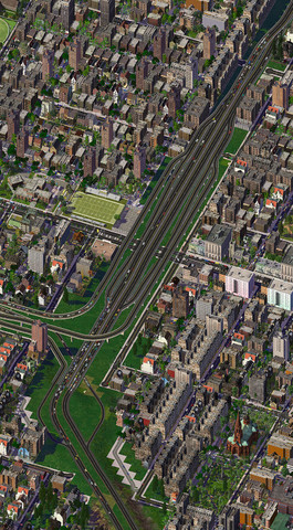
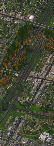
After much too long, it's time for a new episode of Nyhaven! Today, we're looking at some of the city's newer suburbs. All of the areas we're going to visit today are on the islands in the middle of the Columbia River, to the west and south of downtown Nyhaven. We begin our tour on Welch Island, which is home to one of Nyhaven's country clubs. Development on this island has been slow, due to it not having very good transportation links with the rest of the metropolitan area. Welch Island is still waiting to get service on the MetroRail... Just across the slough, on Tenasillahe island, this little neighborhood is tucked between the slough and the island's creeks. Farther to the south and west, we come to the southern outskirts of the city of Barrington. The R-50 crosses the island here on its way between Nyhaven and Kendall, with an interchange serving the suburbs just east of its bridge over the river. Puget Island, however, is the largest island in the metro area. We visited it a couple of updates ago when we saw the athletics park. These suburbs are to the northeast of that park, though still on the same island. Near the top is the R-250, which forms a bypass of midtown Nyhaven for Kendall motorists heading to and from the airport. Towards the bottom is the R-150, which connects the airport to Nyhaven and its eastern suburbs. Those two freeways meet at this interchange, and the R-250 widens to accommodate the extra airport-bound travelers at this point. This area is very popular with residents because of its excellent transportation options; in addition to the two freeways, three different MetroRail lines cross the island in this area. Of course, it doesn't hurt that there are lots of shopping destinations around here, too. Petersen Crossing is the largest mall in the metro area, and it is conveniently close to the R-250, as well as the Loup Avenue station on the MetroRail's Saint Mark's Line. The suburbs aren't all houses and shopping centers, though. Parks like this one make them all the more livable, and on a nice summer day, residents are grateful for these amenities.- 19 Comments
-
- 23
-

-
Episode 3: An Athlete's View
woodb3kmaster posted a City Journal entry in Nyhaven, Lower Columbia (AIN)
When I came to Nyhaven to play soccer, I had heard about the city's athletic facilities. There was ColumbiAir Arena, one of the easiest venues to get to, due to its location in midtown and having its own subway station. As the new rookie in town, I got the chance to ask some of the Huskies basketball players what they thought of their home court. "I've never played anywhere like it," one of them told me. "The atmosphere during games is simply electric, and the neighborhood really adds to the arena's appeal with locals. It's easy to head over to Ebenezer Square after a game for a night on the town, so the stands are always packed." The three venues at Sporthaven weren't as close to the excitement of central Nyhaven, but they still made for great places to play and watch games. Walking along the waterfront gave me unparalleled views of the skyline! What really knocked my socks off, however, was the place where I would train and play for the Nyhaven Cruisers - at Puget Island Athletic Park. It was enormous, and with such good transportation connections, I could practically live anywhere in the metro area and be just minutes from work. No wonder the city chose this park as its Simlympic park back in 1980! The park's Melkovitch Center for Athletic Development was full of young, up-and-coming athletes like me, so it made the perfect place to train. With three different venues, each with a different focus, I could get a full workout in one place. Right across the street from there was Crown Insurance Park, where I would play all my home games as a midfielder for the Cruisers. The stadium had just reopened after a massive reconstruction program, and it had all the best amenities. With my interest in playing for Lower Columbia's national soccer team, though, I couldn't help but visit Jean Le Conte Simlympic Stadium, where the kingdom's greatest athletes had won so many medals all those years ago. I ended up renting an apartment in the park's former Olympic Village, which had been opened to the public as low-cost housing after the Games. It was close to work, and with a station on Saint Mark's Line close by, I could hop on a train and be anywhere I wanted to be in Nyhaven in just minutes. When I came to Nyhaven, I was skeptical that it was what people claimed it was - the sports capital of Lower Columbia. They couldn't be more right!- 15 Comments
-
- 15
-
-
FlashForward 6: Central Station Revisited
woodb3kmaster posted a City Journal entry in Nyhaven, Lower Columbia (AIN)
After doing a bit more work on the station area and the new business district to the east, I think I'm finally happy with how everything's arranged (aside from RCI zones, which are as fickle as ever). Here's an updated picture of the station: The only real change I made is turning the one-way roads on either side of the station into ramps into an underground parking garage, taxi rank, and bus stop. The land that the OWRs previously occupied is now home to a pair of short pedestrian malls; removing the extra OWR intersections behind the station allowed me to add the lane reduction I wanted on Station Street as it approaches Royal Street. The area east of Central Station is now home to another business district along East Center Street. Most of these skyscrapers are newer as a result of urban renewal in the 1970s and '80s. They also have improved highway access, now that the R-3 has new ramps connecting to Center Street (along with an added connection to Nybro Street). The previous view of the East Center Street District faced west, toward Royal Square. This view faces east, with the university at the top. Here's an updated view of Royal Square at night, with the updated station and its surroundings. To put the redesigned station and new business district into context, here's a wider shot of downtown Nyhaven, facing north. Royal Square is roughly centered; the major business districts visible here are (clockwise from top) the Financial District, the East Center Street Corridor, the Market Street Corridor, and the West Center Street Corridor. Also visible at top are Old Town (north of the opera house), with its more chaotic streets and the Western Cross Church; and the Kilterby neighborhood, with its angled grid, north of East Center Street. We'll take a closer look at each of these two neighborhoods in due time... Finally, here's a closer view of Royal Square at night. Click on it to view (and download, if you like) a full-size version that can be used as a 1920x1080 desktop background. Please excuse the game grid that's visible in some of the above pictures. I was having trouble with an anti-malware tool that prevented me from turning the grid off when I took those pictures.- 7 Comments
-
- 11
-
-
Episode 4: An Ethnic View
woodb3kmaster posted a City Journal entry in Nyhaven, Lower Columbia (AIN)
To start Nyhaven's time as the cultural capital of the Alliance of Independent Nations, I'm dedicating a whole episode to the city's many ethnic neighborhoods. This isn't the first time I've done this - I first did it seven years ago, at the start of the Nyhaven 2.0 era - but it's only fitting to start the festivities with a celebration of the many cultures that have found a home in Nyhaven. I've already shown you two neighborhoods - Chinatown and Okatown - in previous episodes, but today, we're going on a tour of 13 more. We begin our tour at Saint Mark's Square, the epicenter of Nyhaven's Mediterranean immigrant communities. Just north of the square is Greektown, with its Orthodox church and... did you hear that? It sounded like thunder. I hope everyone brought their umbrellas, because it looks like it's about to rain. Sure enough, it's raining as our tour reaches New Cattala. The city's Cattalian population has called this area between the square and the University of Nyhaven home since the first immigrants arrived in the 1870s, after Italy invaded and annexed Cattala. Unemployment was high in Cattala at the time, so the prospects of work in Lower Columbia drew many Cattalians across the ocean. Of course, times weren't good in mainland Italy either, so many Italians also immigrated to Lower Columbia. Those who came to Nyhaven settled down just a few blocks from New Cattala, closer to the Elochoman Slough. Tensions between the neighboring ethnic groups were high for many decades, and gang violence claimed many lives in both districts in the early 20th century. Fortunately, those tensions have subsided in the ensuing years. The storm seems to be passing as we reach the Croisian Quarter, or Rive Croisienne as the locals call it. People have been migrating from Sainte-Croix to Lower Columbia since the country's first settlers arrived in the Northwest in the 1560s, but a new wave of Croisian immigrants established this little community on the embankment in the early 1900s. As we reach Little Soviyya to the north of Hunters Island, the sun is just starting to break through the clouds. One of the three communities of Slavic immigrants near Burgess Square, this neighborhood lies just south of the square and west of the R-3 freeway. On the other side of the square is New Moscow, with its ornate Russian Orthodox church. A few blocks north of Yule Avenue, we come to Hiigara Town. The various crises and conflicts that have engulfed the Hiigaran United Confederacy and its member states over the years sent many Hiigarans in search of safer homes. Those who came to Nyhaven settled here, around Lower Columbia's only Kran'et temple. Crossing onto Hunters Island, we come to Little Tokyo. Like most immigrants from East Asia, the Japanese chose to settle on Hunters Island, specifically, just south of East Center Street. Many of the business executives who work in the neighboring towers come here when they want a little taste of home. Further south, close to midtown, is Nakamatown, where Nyhaven's Nakamese population is centered. As we approach the southern tip of Hunters Island, we reach Koreatown. Located close to Cathlamet and the local campus of Royal University, Koreatown has become popular with both students and boaters. Returning to the mainland across from uptown Nyhaven, we come to Spanish Town. Our tour is almost at its end... Finally, we visit two neighboring ethnic districts. To the west is New Casablanca, which is home to Nyhaven's largest mosque, as well as most of its Moroccan-born residents. To the east, meanwhile, is Little Ascadylea, on the other side of Hazel Avenue.- 11 Comments
-
- 11
-
-
- neighborhood
- nyhaven
- (and 2 more)
-
After an extended hiatus, I'm proud to bring you a selection of photos from Kendall, Nyhaven's nearest major city and the capital of the Federal Kingdom of Lower Columbia. Today, I have four massive mosaics to show you, spanning most of the built-up area of Kendall. Each of them crosses at least one city border and shows areas I've never shown before, so get ready to see more of Kendall than you ever have! This first mosaic, facing east, runs from Parliament House and the Royal Library at the top, past Kendall Palace and the embassies, to the inner suburbs west of the Government Quarter. Fitzsimmons Square the the two residential squares I featured earlier are also visible. Facing south now, we start near Federal Circle, the de facto central business district of Kendall, and follow the transverse arm of the Royal Promenade from the Royal Cathedral to the Palace of Justice. After passing by Justice Park, we come to Port Brunsmjöd, the regional container port, and the marina at the Brunsmjöd village. This north-facing mosaic starts up by the northern embassy district and shows parts of all three embassy neighborhoods, as well as most of the Kendall Palace grounds. Across Gnat Creek, we come to the campus of Royal University, Kendall - the flagship campus of its system. At the bottom is the university's Dukes Stadium and the neighboring University Village. Our last mosaic for today faces west, and it's the longest one I've ever made - so long, in fact, that Photoshop had to shrink it to export it. Starting in some of Kendall's interwar suburbs on the south bank of Gnat Creek, we pass through the western half of Royal University's campus. After visiting the southern embassy district again, we reach the Royal Cathedral before moving on to South Station. Parliament House is just off-screen as we climb the hill that many residents call Flattop, which is home to the capital's largest affordable housing projects. At bottom is the R-50 freeway and its complex interchange with Pacifica and Willamette Avenues.
- 15 Comments
-
- 14
-
-

-
Three Interchanges and a Park
woodb3kmaster posted a City Journal entry in Nyhaven, Lower Columbia (AIN)
Today's update title says it all: I have four images for you, three of various freeway interchanges, and one of a local park. Each of today's interchanges was made possible (or at least easier to build) by NAM 33's new features, especially the improved and expanded FLEXFly repertoire. This picture shows the R-50/R-150 corridor, from Cathlamet to the suburbs east of Midtown. As part of the efforts to extend the R-150 to the north, it has been separated from the R-50 mainline. The interchange between the two highways has also been redesigned to eliminate left-hand exits from the R-50, while still allowing traffic to flow in every direction. Now, the R-150 serves as a sort of "express lane" option to the busy R-50, with no exits of its own to surface streets (although a new interchange at 24th Street, near the top of the image, is under discussion). This is Cool Hollow Park, right next to part the northernmost part of the above interchange. The observant among you will notice that I've redesigned the R-50/150 split a bit; technical constraints forced me to adjust the split's layout to avoid an impossible situation (i.e. three networks on the same cell). Thanks to some of the new features in this NAM version, I was finally able to finish the R-3/R-50 interchange in midtown Nyhaven. Unfortunately, technical limitations prevent me from running 16th Street right under the flyovers, so I've had to improvise to keep traffic flowing. Further north on the R-3, we come to the new northern terminus of the R-150. Drivers approaching from the south (top of this picture) can now choose whether to exit the freeway at Yule Avenue or continue onto the southbound R-150. I had to do quite a bit more demolition than I wanted to in the neighborhood surrounding the interchange, but such is the nature of trial-and-error construction.- 12 Comments
-
- 14
-
-
Nyhaven and Kendall: One Metro Area
woodb3kmaster posted a City Journal entry in Nyhaven, Lower Columbia (AIN)
For those of you who weren't aware, Nyhaven and Kendall are part of the same metropolitan area. In fact, they're the two largest cities in the metro area. The following animation shows my progress in building and merging the two cities over time (up to about a week ago): I've done even more work on the metro area since the date of the last region view here, but Photoshop refuses to export an updated GIF (probably due to a memory shortage or summat). EDIT: After shrinking the image and reducing the animation length, Photoshop finally exported a new GIF. I've edited it into the space above. However, you can see some of my latest work in the Kendall thread. At this point, even the two subway systems have merged, creating a 20-line monster that's so big, it would be a nightmare to try to name each line the way I'd been naming them. Hence my decision to replace the names with letters and numbers, as the latest subway map shows: My latest work on Kendall was almost lost due to the city contracting prop pox. Thankfully, after doing a great deal of reading on prop pox's causes and preventive measures, I was able to continue from a recent, pox-free backup, and my preventive measures have kept the pox from reappearing. Here's some of that work, which includes my efforts to merge Kendall and Nyhaven into a single metro area. The Lords of Parliament, Lower Columbia's two heads of government, now have a residence and office that suits them. The leaders of Parliament's two chambers live and work in separate wings of Columbia House, shown here. This executive mansion is right across Upper Columbia Avenue from Parliament House itself. Based on earlier comments, I've worked on reducing building repetition around Federal Circle. I've also begun expanding the business district that surrounds the circle, so it hasn't completely filled in yet. I also acted on comments regarding the proximity of the seaport to central Kendall and completely rebuilt the area. Now, housing projects rise where cranes and stacks of containers once stood. I also rebuilt Edmonds Junction, the rail junction connecting Kendall's Library Terminal to the port and points beyond, to take advantage of the new FlexTrack features in NAM 34. The rebuilt Port Brunsmjöd now sits on its own island, with many more berths for ships and greatly improved rail and highway access. Pacifica State Highway 32 (visible in the top-right corner) runs through the port areas next to the port's rail line. PC-32 begins at this rebuilt interchange with the R-50, where the latter highway turns south into central Kendall. Due to this interchange's proximity to another one, the R-50 widens to 10 lanes here. That other interchange is where the R-250 ends. This freeway gives Kendall access to Nyhaven International Airport and runs through a number of new suburbs. The R-50, meanwhile, continues east into midtown Nyhaven. The largest of those new suburbs is Clifton Mesa, a massive planned community near the formerly-small village of Clifton. Huge earth-moving operations leveled the hills that once stood here to collect land reclamation material for Port Brunsmjöd in the 1960s, and city planners took the opportunity to build a suburb that would serve both Nyhaven and Kendall. Clifton Mesa is home to one of the metro area's largest shopping malls, and is where several subway lines from both cities intersect.- 15 Comments
-
- 24
-
-
Rebuilding a City From Scratch
woodb3kmaster posted a City Journal entry in Nyhaven, Lower Columbia (AIN)
Well, prop pox struck Kendall again, and there was nothing I could do to reverse its effects. Rather than limit myself to taking pictures of unaffected parts of the city, though, I decided I had to start over. Rebuilding a city as developed as Kendall - with over 500,000 residents and most of the map developed - was a daunting task, to say the least. I was committed to recreating the city as accurately as I could, so I needed a guide to the old version of the city. Thankfully, SC4 Savegame Explorer has a feature that displays a map of all the lots, buildings, or props in a quad (depending on which subfile you open), so mapping out all of Kendall's lots and transport networks was fairly easy. The hard part was labeling almost all of them, so I knew what to plop where. I also needed to make an accurate subway map, so I referred to the in-game traffic volume data view quite a bit. My final map ended up looking like this: By following this map, I was able to rebuild Kendall exactly as it was. But rather than slavishly recreate every detail, I took this opportunity to make a few improvements to the city. One of those improvements was rebuilding all of the R-3/50 freeway as a RHW (it used to be an overridden Maxis highway). Here are a couple pictures of how that effort turned out: This is the freeway's interchange with Pacifica and Nicholasia Avenues. Based on fan comments, I decided to rebuild this interchange in a trench to minimize the freeway's elevation changes. The new version also keeps the longer offramps grade-separated all the way to their ends, which should improve traffic flow. Further down the R-3/50, I built these overpasses. I ended up having to learn about the RULs the NAM is built on in order to fix a bug that affected the avenue overpass, which led to me becoming a full NAM Team member. I also made a couple new lots to replace temporary layouts. Here's the new Arts Plaza, at the intersection of Puget and Nicholasia Avenues. For the most part, though, I just wanted to get as much of Kendall to look as it once did as I could. I'm pretty satisfied with the results; the new Kendall is as vibrant and busy as the old one was. My efforts even match up across quad borders, as this mosaic shows. I made some improvements to the campus of Royal University, Kendall, as well. The flagship campus of Lower Columbia's federal university system, RUK was founded by King Edward as the Royal College in 1733. This legacy as a former college lives on in the names of College Street (which ends at the campus administration building) and the College Park neighborhood. This is an overview of the whole campus and its surrounding area, facing west. The oldest part of campus is in the middle, with the residential annex at bottom, and several of the university's newer buildings near the top, along with some of the fraternity houses of College Park. The football stadium's parking lot is also partly visible at left. Farther down the mosaic, College Street crosses the channel into the Federal Circle business district. The western half of campus is home to Mikaelslot, one of the university's largest pre-20th-century buildings. Originally built by King Michael I as an alternative to Kendall Palace, Mikaelslot and its grounds were gifted to Royal University by Michael's successor, Brandon I. Although the former palace was quickly used for classes and office space, the palace grounds were neglected until the 1950s, when the university needed to add new facilities. Most of Royal University's science and engineering classes now take place in the buildings that were built on the grounds. The east end of campus is where most of the dormitories are located. This is another area that wasn't originally part of Royal U's campus; it was purchased from the city around 1960, when the student population outgrew the old dorms. Finally, although Lower Columbia is an overwhelmingly Christian nation, it also has a growing population of Muslim immigrants. They recently built the Malkut al-Hijra Mosque on the edge of the Kendall Heights, east of Parliament House. Its construction was controversial, due to its size and prominent position overlooking the city center. It's here to stay, though.- 9 Comments
-
- 17
-
-
Today's update is a little more, shall we say, utilitarian than usual (okay, you can stop groaning at that pun now). I've shown Nyhaven and Kendall's transportation infrastructure here plenty of times, but until a couple of months ago, I had neglected the even-more-important electric infrastructure. After all, without a constant supply of electricity, what would power the metro area's economy? (Okay, I'll stop punning now. ) I recently finished working on my first modular nuclear power plant, the Marshland Nuclear Generating Station. While most of Lower Columbia's old uranium-fueled nuclear plants have been decommissioned or converted to thorium-fueled reactors, this beast of a power plant is still active, just upriver from Nyhaven International Airport. Here's another view of the plant, showing some of the high-voltage wires carrying its gigawatts of power to the whole region. I recently replaced the wired pylons I originally used with these larger, wireless ones; this change allowed me to increase the spacing between them to something more realistic, while the invisible transmission lots I added keep the lines functional. The only catch is the lack of true FA3 pylons; I've substituted the turn pylons to simulate them, since they're at roughly the same angles. Some of the power lines running from this plant follow the railroad west past the town of Marshland (which, as you might imagine, is the plant's namesake). The town rail station was greatly expanded when the nearby industrial park was built. Marshland sits at the edge of the metro area (for now). But it isn't the edge of the region anymore! The Marshland quad used to be in the southeast corner of the region, but thanks to my painstaking efforts, the Nyhaven region is now twice its former size - 99 large quads instead of 49 (or roughly 44x36 km vs. 28x28 km). In fact, the first two pictures above wouldn't even have been possible before I expanded the region, since they cross the border into two of the new quads. Now I can build Kendall's suburbs as far out as I want - and as you can see, I've already done a lot of work on them. In all, the region is now home to 3.3 million people, thanks in part to those new suburbs. What's with that big black box labeled "SECRET", you ask? Well, you'll find out before long. Suffice it to say, though, that it will be no flight of fancy...
- 10 Comments
-
- 17
-
-
Version 1.0
2,498 Downloads
This is a collection of six parks for use as standalone urban squares. I originally made them for my own use, but I was encouraged to make them available to the SC4 community. Three of the squares are mostly grass, while the other three are mostly paved. All of them use seasonal flora, so you can expect to see the trees change as time passes. Note that this also means that all seasonal props will not be visible when you first plop the lots. For screenshots of these squares as they appear in my cities, see my CJ, "Nyhaven, Lower Columbia". Sizes vary from 8x6 to 9x8, plop costs from $360-800, and monthly costs from $10-15. Each lot reduces air pollution in the surrounding area. Make sure you have the following dependencies installed, or else you will have a lot of missing props and textures: Plugin Landmark Props BSC MEGA Props - CP Vol01 BSC MEGA Props D66 Vol01 BSC MEGA Props D66 Vol02 BSC MEGA Props - Gascooker Vol01 BSC MEGA Props - MJB Vol01 BSC MEGA Props - Misc Vol01 BSC MEGA Props - SG Vol 01 BSCBAT Props D66 Vol11 Modular Zoo and Aquarium Addon Pack 01 (you only need the file "Zoo food stand props V1.dat" from this set) NDEX Konietzko Fountain (you only need the main model file) BSC TexturePack Cycledogg V 01b NDEX Texture Set Volume 1 BSC Textures Vol 01 BSC Textures Vol 02 BSC Textures Vol 03 Yes, this is a long dependency list. However, if you have a lot of plugins, chances are you already have most of the above files. Thanks to the makers of all the props I used, with special thanks to Cycledogg for his seasonal flora. They are the real stars of these lots! Thanks also to everyone who gave me feedback as I was developing these lots. UPDATE 2016-06-26: Dependency links updated. -
And then there are the joke uploads, like all the iterations of Nuclear Starbucks. There's always room for the occasional humorous plugin... Anyway, this discussion got me to go back and fix the dependency links in the only one of my uploads that even has dependencies, so kudos for inspiring at least one content creator to fix something!
-
Rebuilding a City From Scratch
woodb3kmaster commented on woodb3kmaster's City Journal Entry in Nyhaven, Lower Columbia (AIN)
@tankmank, @Ln X, @kingofsimcity, @michae95l, @raynev1: Thank you all very much! As challenging as it was to rebuild a city this large, replies like yours make the process well worth it - and of course, I'm quite happy with how the rebuild turned out, too. @Belfastsocrates: Thanks! That government district is one of my favorite creations, so to see that someone as good at building grand public spaces as you loves it is really high praise. @tariely: Thank you very much! That blue plaza is one of my own creations, but the building you asked about is the National Art Center from Ottawa, Canada, by otty8116. @totalnoob: Thanks for your compliments on the campus! Tha first building you asked about is the CSX National Library, while the nearby buildings are the Statistisches Bundesamt, St. Addieline's Hospital, and the NGV International. -
Nyhaven and Kendall: One Metro Area
woodb3kmaster commented on woodb3kmaster's City Journal Entry in Nyhaven, Lower Columbia (AIN)
@Linoa06, @mrsmartman, @TekindusT, @Ln X, @kingofsimcity, @jmsepe: Thank you all for your kind words! @tariely: Thank you! Those houses perched above the interchange were actually there first; I rebuilt the interchange after developing that neighborhood. I see your point about putting Tung Chung Crescent right next to the New York high-rises, but it's sadly a moot point now, as I had to demolish both due to cyclical abandonment. @Benedict: Thanks, Ben! I enjoyed coming up with the line names, but when your subway system has 20 lines, it gets hard to come up with interesting new names. Glad you like the map! @GreekMan: Thank you! I ended the old, forum-based Nyhaven CJ, but I left myself the option of reviving this version in case I had the time and interest to post updates again. @Jacob_G2013: Thanks! The building you're looking for is Tung Chung Crescent. @JoshuaGellock: You'll be glad to know that the viaduct in question has been replaced with an avenue underpass. @kschmidt: Thanks! See the tutorial I linked to above to learn how I made that giant roundabout. -
BTT (CJ Section): 17 December 2015
woodb3kmaster commented on Benedict's City Journal Entry in Ben's Top Ten +10: CJ Section
Nice to see that my return was so well-received (#2 the previous week). Keep up the good work, Ben! -
Nyhaven and Kendall: One Metro Area
woodb3kmaster commented on woodb3kmaster's City Journal Entry in Nyhaven, Lower Columbia (AIN)
@kschmidt: I think you'll find this new tutorial useful: https://www.sc4devotion.com/forums/index.php?topic=17390.0 -
Three Interchanges and a Park
woodb3kmaster commented on woodb3kmaster's City Journal Entry in Nyhaven, Lower Columbia (AIN)
@raynev1, @TekindusT, @Urban Constanta, @kschmidt, @slickbg56, @lucasfg3, @Compdude787, @takemethere, @dabadon5: Thank you all very much for your compliments! Replies to specific questions/comments are below. @tariely: I'm honored to be your inspiration! Most of the cars in these pictures came from traffic generator lots, which just spawn automata on nearby networks. The specific set of traffic generators I use is @blue sinjid's American Traffic Generator re-lots, but there are many others on the STEX as well. Now that my highways have more actual traffic, though, I don't really need to use them anymore, especially since I use one of the NAM's radical automata files. -
From the album NAM Showcase - Monthly Challenge #5
Link to full-size image: HERE Further north on the R-3 from my previous image, we come to the new northern terminus of the R-150. Drivers approaching from the south (top of this picture) can now choose whether to exit the freeway at Yule Avenue or continue onto the southbound R-150. I had to do quite a bit more demolition than I wanted to in the neighborhood surrounding the interchange, but such is the nature of trial-and-error construction.-
- 2
-
-
- freeway
- interchange
- (and 2 more)
-

From the album NAM Showcase - Monthly Challenge #5
Link to full-size image: HERE Thanks to some of the new features in NAM 33, I was finally able to finish the R-3/R-50 interchange in midtown Nyhaven. Unfortunately, technical limitations prevent me from running 16th Street right under the flyovers, so I've had to improvise to keep traffic flowing. -
-
Kendall Mosaics Aplenty
woodb3kmaster commented on woodb3kmaster's City Journal Entry in Nyhaven, Lower Columbia (AIN)
@raynev1, @gviper, @Brandtinc, @streetsofny, @Spy9600, @MissVanleider, @KRMill09, @TekindusT, @Mymyjp: Thank you all very much for your kind comments! Replies to specific questions and more detailed critiques are below. Thanks, @michae95l! The palace is Drottningholm Palace by Mrqs, the parliament house is the Hungarian Parliament Building by yoder7562, and the courthouse is the Palais du Luxembourg by xannepan. Thanks, @kschmidt! I know the seaport is awkwardly close to the city center, and that's partly due to it being in a neighboring city (thus limiting my perspective on where to place it), but I like to think that that part of town was redeveloped from slums to the current port in the 1960s. Whether you think that's an improvement or not is your call, of course. The highway, meanwhile, is elevated due to space constraints; a sunken RHW in that area would have taken up much more space, and I wanted as narrow a right of way as I could manage. Nevertheless, I appreciate your detailed thoughts! Thank you, @tariely! My justification for the grid-heavy suburb you mentioned is that it was built in the early part of the 20th century, before suburb planners stopped using grids so much. It wasn't until around the 1950s (at least in North America) that city planners started laying out suburbs in more free-form designs. As for the palace grounds (the park you mentioned), that is one of my custom creations. Due to its size (24x24 in total), I had to split it into three lots to get it the way I wanted it. -
From the album NAM Showcase - Monthly Challenge #5
Full-size mosaic here This picture shows the R-50/R-150 corridor, from Cathlamet to the suburbs east of Midtown. As part of the efforts to extend the R-150 to the north, it has been separated from the R-50 mainline. The interchange between the two highways has also been redesigned to eliminate left-hand exits from the R-50, while still allowing traffic to flow in every direction. Now, the R-150 serves as a sort of "express lane" option to the busy R-50, with no exits of its own to surface streets (although a new interchange at 24th Street, near the top of the image, is under discussion).© 2015 woodb3kmaster
-
- 7
-
-
- rhw
- interchange
- (and 2 more)
-

From the album Weekly Challenge #19 - Sports Complexes
Long before it served as the Simlympic park for the IV Summer Games, Puget Island Athletic Park was a mecca for up-and-coming Lower Columbian athletes. The Simlympics only made it even more popular. While the park's temporary Simlympic venues have come and gone, other venues built for the Games still exist - most notably the Jean Le Conte Stadium (center-right), where the opening and closing ceremonies were held. The park is also home to the Nyhaven Cruisers' home field, Crown Insurance Park (cut off on the left). With the R-250 freeway just outside the park's borders, a rail station, and four subway stations serving it, the park is accessible in just minutes from anywhere in the Nyhaven metropolitan area.- 1 Comment
-
- 1
-
-
- nyhaven
- lower columbia
- (and 4 more)
-
Can I apply the 4GB patch to the game's steam version?
woodb3kmaster replied to cmdp123789's topic in SC4 Bugs & Technical Issues
If I'm not mistaken, you were supposed to uninstall the CD version before installing the Steam version (it's what I did, and you won't lose any of your plugins, regions, etc.). I don't know whether that's the cause of your issue or not; I'll let someone more knowledgeable determine that. I don't know what SC4 Launcher Indiana Joe was talking about, but I imagine it's similar to the one I use, SC4 Startup Manager. At a minimum, it should let you customize your SC4 startup settings (e.g. restrict to one CPU core, run in windowed mode, etc.) and run the game with those settings applied. -
Can I apply the 4GB patch to the game's steam version?
woodb3kmaster replied to cmdp123789's topic in SC4 Bugs & Technical Issues
Hmm, I had forgotten about the 4GB patch. I have Amazon's download version now (having replaced my old disc version, because Windows 10), so I'll have to try it out. Re: more crashes, I've definitely noticed it since switching to my Amazon version. In my case, they seem to occur when I try to do something resource-intensive, like rotate the map or take a picture. Assuming the processor fix that Indiana Joe mentioned is what I think it is (-CPUCount:1), the 4GB patch may well fix this new CTD issue.
