

-
Welcome to Simtropolis!
A community dedicated to SimCity 4 and all city-building games. (About Simtropolis)
-
Announcement
-

Simtropolis Returns! 05/26/2026
See here for details about our site recovery efforts.
-
 Supported
City Journals
Our community City Journals
-
 Latest Entry
Industria Planitia: Transforming the Red Planet
Industria Planitia may be far from the boundaries of Earth, but as time passed, the Underwood Industrial Empire joined those who dared to attempt what was previously believed to be unthinkable: To turn the Red Planet green.
In a joint session of the Congress of the Confederation, Grand Admiral Underwood proposed that the U.I.E. join forces with other nations with colonial holdings on Mars to tame the harsh environment of the fourth rock from the Sun. Given that it was along the same lines as the work being done to restore the region around Trinity River, the Governor-General of Industria Planitia, Dr. Lukas Indrick - arrived that morning aboard the UIEV Perseverance, the ship that ran from the colony to Underwood City - proposed that a number of geological engineers from that city, as well as scientists from the U.I.E.'s various colleges versed in ecological disciplines, return with him. The Lord Mayor of Trinity River was not keen on the idea, however; having the engineers go to Mars meant that they would not be actually working on Trinity River. The leaders of Amesport, New Providence, and Montagne Noire also protested, believing that the money would be better spent on matters "closer to home", such as building up the military to counter the fears of a renewed threat from Defileron - and possibly a landgrab by Vladimir Tsiolivosky, the new Caymarnian Emperor.
Backed by the Chancellor of Blackstone University, Illuminopolis' de facto mayor, Grand Admiral Underwood made clear that he supported the initiative. However, that did not mean the "Earthbound holdings" of the U.I.E. would be neglected either. To the contrary: The Ministry of Economics had indicated to him that, should the speculation of considerable metal resources in the region around Industria Planitia prove true, the goods returned from the colony would more than equal the expenses invested in maintaining it, and in fact produce a surplus that would allow them to accomplish both goals. Remaking the Red Planet into a habitable form would be an added bonus. "Industria Planitia is the future of the Empire," he said in his concluding remarks. "If we can pull this off, nothing will be beyond our reach."
With the support of the Congress (grudging in a number of cases, but support, nonetheless), Grand Admiral Underwood committed the U.I.E. to the initiative. To tame the Martian environment, the plan essentially called for brute force: to thicken and strengthen its weak atmosphere with mixtures of carbon dioxide, to raise its frigid surface temperature with greenhouse gases, to raise those conditions to allow for liquid water, and to make the air and soil support plantlife to produce oxygen. To increase the supplies to and from the colony as needed, five new ships were commissioned in the New Providence yards to run the Earth-to-Mars route to provide personnel - and more importantly, materiel - to carry out the mission. A historian at heart, Grand Admiral Underwood personally named the first two ships UIEV Erebus and UIEV Terror (only half-jokingly expressing the hope that they fared better than their namesakes) as well as three more for the men associated with those lost polar ships: UIEV John Franklin, UIEV Francis Crozier, and UIEV James Clark Ross. They complimented the UIEV Trailblazer, UIEV Perseverance, and UIEV Hyperion, which had been running the route since the colony was established. Reports of the progress were communicated between Governor-General Indrick and the U.I.E. Space Agency Mission Control Center in Amesport, as well as by the captains of the ships making the regular run to and from Industria Planitia.
The results were nothing short of spectacular.
Beginning with "baby steps", the plan called for the construction of specially-designed factories to produce the necessary atmospheric chemicals, as well as "forestation plants" to plant the seeds of the plant life that would grow on the surface. Much of the colony had to be redesigned, as the geological engineers brought along terraforming equipment to level the surface and remove larger rocky outcrops around the colony. A large part of the work involved tearing down and rebuilding the modular colony structures to make room for the new GHG plants, carbonate processors, and forestation plants.
As the landscape work progressed, the surveyors also happened to find strange crystals on the surface that obscured satellite scans, though their purpose remained unclear; they did discover that the crystals were attracted to the power generated by the colony, and powering them up cleared up the sensors. They were later found mysteriously shattered, again with no explanation.
"Lakes" were dug into the surface and filled with water produced by the colony's extractors and vaporators. As the temperature rose, the water liquified.
The forestation plants had begun first with lichens; as the surface conditions improved, grass began to grow in certain areas; further on came bushes and trees.
As a drastic measure, a massive payload was detonated at Mars' north pole with the force of a thermonuclear blast, the heat and energy causing the polar ice cap to melt, creating an ocean that covered much of the northern hemisphere. By some stroke of luck, Industria Planitia - located on a volcanic plain near the equator - escaped being swept away by the flood, essentially becoming an island surrounded by high crags. In a relatively short time, the Capital - the dome where Governor-General Indrick maintained his office - was surrounded by a forest. Though the atmosphere could not yet sustain biological life, he immense moisture released by the melted ice cap, combined with the introduction of CO2 and other greenhouse gases, began to take hold, and the inhabitants of Industria Planitia began to see blue skies for the first time since they had left Earth.
As time went on, the work steadily progressed; the Erebus and the Terror were regularly sent around Mars with vessels from other settlements, seeding clouds to produce rain (another novelty not seen by the colonists since leaving Earth) while trying not to make it toxic; seeding vegetation much like the forestation plants, in order to make it take hold; capturing ice meteors, for the water. The Hyperion was ultimately sacrificed in order to deploy a sort of "sunshield" to preserve Mars' weak magnetic field and contain the atmosphere, complimenting facilities built on the surface for that purpose (which also had the potential to produce "Marsquakes" in the otherwise seismically dormant planet).
After long and arduous work, the ultimate goal was achieved.
Communicating with Grand Admiral Underwood via a live satellite link with Mission Control in Amesport, Governor-General Indrick formally gave the order: "Lower the domes!"
Even then, the work progressed on expanding Industria Planitia itself. To celebrate the new beginning, Governor-General Indrick ultimately elected to relocate his seat of government. The "old" Capital would be preserved as a museum for future generations, while work began on the "new" Capital - a far larger district, one too large for a dome. From its spire, he would oversee his domain - and take pleasure in both the work that had been done, and the work that lay ahead. The new Capital and the fact that it was (and would forever be) non-enclosed was also a testament to the confidence of the Governor-General, the U.I.E., and the multi-national initiative that had done the work - they were certain nothing would ever go wrong.
The colony has since expanded even down into the canyon to the south, through a connecting tunnel on the canyon floor. Here, the soil remains more or less untouched, though the work is underway to change that.
The idea of a Martian colony being admitted as a full-fledged member state was looked at with skepticism by many within the U.I.E., but thanks to the terraforming initiative that has utterly transformed Mars, the question has been settled so far as its supporters - namely Governor-General Indrick and Grand Admiral Underwood - are concerned. Distance was of no issue before, and now that the colony is free of the confinements of domes and pressure suits, the remainder of the confederation now concurs: Industria Planitia is no longer simply a colony, but a city in its own right.
- Read More
- 0 Comments
-
- 15
Entries - 42
Comments - 8696
Views
Recent Entries
 Latest Entry
Quick Asia Tour
Liberty Square - Taipei Shinjuku - Tokyo Sungryemun - Seoul Pudong Financial District - Shanghai FOLLOW ME (AND MY CITY JOURNALS) ON:
INSTAGRAM | TWITTER- Read More
- 0 Comments
- 15
-
- 5
Entries - 10
Comments - 374
Views
Recent Entries
 Latest Entry
Ep.4 - Petit Census Series Pilot
Welcome to Petit Census Series, my name is Dewit Petit, you may remember me from such shows as "A Kitchen on Fire" and "Jurassic Rodeo". As always I am very happy to have you here, hopefully as excited as I am, to start this journey together. Now. We might not all get together until the end, but I am positive we will have a good time and be joined by new ones on the way. Right. Let's get this show on the road, shall we? DAY ONE We depart Delfoni Settlers Bay harbor on a river steamboat. Fortunately the weather is fair and not too warm. We packed only the journalist equipment, so cameras and film, notepads, pens, and a few microphones. We will use resources in situ to minimize our footprint - the sponsors will provide the means to pay for these services, and they will also get publicity in the process. It's a win-win. The morning of the great first day is always the most nerve-wrecking. I ran through our checklist at least 10 times, even though we don't really need much more than ourselves, so, should we forget anything it's not a big deal. But perharps I should introduce our crew:
- Emeline Elm. She is my long time friend, a terrific travel agent, and we worked on such shows as "Jurassic Rodeo" and "Apex Ring". It's an understatement to say I am grateful she is on this trips with us. - Verti Swivel is an experienced Wilderness Ranger. Before he started to work with me he was stationed at Rodigate, overlooking the train traffic coming from the open wild. He knows quite a bit about the monsoon and the patches of rain forest, and the creatures that lurk in there. Those are not the same as in "Jurassic Rodeo", let me tell you that. - Lionel Hammel. Fellow journalist and camera operator. We often switch roles as needed, but I definetely could not do it without him. And off we go! DEPARTURE: Delfoni Settlers Bay Port, early morning
TRIP: Rodi River Delta Rielly Distributary upstream, during the day. Lots of mosquitos.
ARRIVAL: Codnor, evening Codnor is barely even a town. When we arrive, one of the first things we find out is that the pier we dock at has just been assembled - for us. They go on to tell us about the harbor and railroad projects as if everyone in the village was an engineer. Come to think of it, they probably are... They offer us dinner at the tavern and we have us a small but warm party on the first night.
DAY TWO
The following morning we interview the project leader at the tavern and he explains to us the basics of the project: TOPIC: Quicke-Delfoni Rail Mainline connection The construction of a small harbor will serve as a stop and also as a platform for the construction of the railway bridge. The mainline will run south to Dagondale and the other bridge project. Estimated completion date: 1925. DAY THREE DEPARTURE: Codnor, morning
TRIP: Rodi River Delta Rielly Distributary upstream, during the day
ARRIVAL: Dagon, early evening
One day and many mosquito bites later we arrive at South Dagondale. From there we are picked up by coach and delivered to the Inn. After a little R&R we explore South Dagondale and North Kendalmut This south-facing image shows South Dagondale port and railyard. The rail line travels south and uphill through a tunnel to North Kendalmut. Another south-facing image. This one shows the rail network coming together before North Kendalmut. Far left is the sawmill line and the rail yard tunnel. On the right it's the mainline. This section is currently industrial-only as it ends up in a yard, with a stub leading to the Dagondale bridge construction yard. A growing North Kendalmut at dusk, right before we settle down back in the Inn. This image is facing north. The new mainline elevated station is operating and trains have started regular shedule from Kendalmut to Rodigate and off to the rest of Soridea. DAY FOUR TOPIC: Mainline bridges and line hookup and stations North and South Dagondale have the important task of building the second rail bridge to link up the vital mainline to Delfoni. To achieve this they need to build harbors and prepare the river bed. We want strong, long-lasting bridges, right? South Dagondale has also the task of linking the mainline to North Kendalmut. There are several additional lines growing out of the need for more industry that need to be linked up to the mainline. However, the common argument against this project we hear about is that many people don't like the idea of mixing industrial with passenger lines. We think these people are not looking at the big, long-term picture: there will be dedicated lines in the future. But right now, priorities are other. So, people, hold on! DEPARTURE: North Kendalmut, late afternoon
TRIP: direct train journey during early evening
ARRIVAL: Rodigate, evening Once we switch to the rail line as a means of travel, the ride gets incredibly more comfortable and faster, and there are no mosquitos. However, we kind of miss the sense of adventure the river steamboat provides, by cruising upriver in those wild unexplored areas. I can imagine skyscrapers and freeways taking the place of the swamp... "Excuse me? Waitress? There must be a mistake! I ordered a main hub rail station, but all I got is this..." DAY FIVE Yeah, we weren't impressed with Rodigate's train station. The Inudstrial yard is much more curated, however: Cleraly, up until now, focus has been put into the construction and freight business, rather than comfortable and reliable passenger transportation. Currently, if you're looking to travel from Delfoni to Quicke or Estar, you're better off on a ship than to venture on the precarious rail line, unless you hop on one of those big noisy freight trains that scare away even the most stubborn of creatures. We are starting to feel the need for reliable passenger rail, though, with the growth of Delfoni and the rest of the nation. A quick stay in Rodigate. Before we can have our next interview, we decide to visit all the places included in the project, so we push on to Wick. DAY SIX DEPARTURE: Rodigate, morning
TRIP: ferry to Apelby, then train to Wick, during most of the day
ARRIVAL: Wick, early evening And back to Rodigate the following morning, same route. off we go! Apelby. Image facing west. Wick. Image facing norh. DAY SEVEN TOPIC: train hubs and the Rodi Bridge project Once back in Rodigate we interview the project director Nil Lawrence. "The focus of this project is the Quicke-Delfoni mainline. A sub-project includes the Geite Line that will connect Delfoni with Estar via the Geite mountain range and also link Delfoni to future farmlands. This sub-project also includes a major bridge to cross the Rodi river. This major bridge will not only serve the Geite Line but provide access to the west side for regular passenger and freight traffic." He goes on to explain the project in more detail. But we thought we'd compress some of it for the sake of this series: "In order for this whole project to work Rodigate needs to be upgraded to a major train hub. We also designated Wick as mainly an industrial train hub. We liased with entrepreneur Rodni Gulli to cooperate on construction and development of Wick's railyard, with all the needed facilities to support long-range travel.[...] Regarding this: (image facing south) "We initially envisioned the major bridge as a one-off work to connect Rodigate to the opposite shore. Later on, additional commisions and requests saw us update our view and we had to abandon this old project in favor of the new one, a bigger, wider, smoother bridge, landing in Apelby." At the end of this first week we have mixed feelings already. On one hand we are disappointed and disillusioned about our current colonial situation in Delfoni. We were promised a flourishing metropolis in a safe area but we are far away from being a metropolis, and also not quite in the safe department. There is still an urgency for fences and rangers. On the other hand, though, we have clearly seen how hard the council is working to realize those initial promises. It might not have been an easy task to colonize this place, but it doesn't seem to be impossible to create a metropolis in a tropical river delta. The journey ahead of us has only just begun... So this is it for the first entry. Join us next time, and if you are into the social media frenzy, then feel free to like, comment, and subscribe. - 5
-
- 3
Entries - 10
Comments - 350
Views
Recent Entries
 Latest Entry
Bituminous Bassetboro
Beagleland was destroyed when Lord Hoagie's ego exploded. The surviving sims sailed across the Beggin' Sea and founded Houndsylvania. They foolishly elected (Lord) Hoagie E. Mellon as the first mayor of Bituminous Bassetboro. The town proper sits halfway up Mount Kibble. Water Bowl Lake and the Rabbit Scent Trail combine to form a national park in Houndsylvania. There are bituminous coal mines that are the town's main employer (all owned by Baron Hoagie E. Mellon). Baron Hoagie swears neither the mines nor ores are the town's namesakes. Sims wonder, however. Thanks to Water Bowl Lake, Bituminous Bassetboro hosts a water tower, despite its tiny population size. On the west side of town, Rabbit Scent Trail begins. Water Bowl Lake: ---------------------------------------------------------------------------------------------------------------------------------------------------------------------------------------------------------------------------- I tried to kind of recreate a small mining town for the general look of this entry. Mods include LK Appalachian terrain, SHK Brigandine 2.0 Water Mod and HD Rock Mod, NAM, Peg's ponds, mmps. BATs by Matt325, Simmer2, Simgoober, Paeng, BSC Newman Mine, lots of mmps by giraffe, peg, simmer2, murimk, NBVC----------- so thanks to these modders x10000 Thanks for visiting my CJ - 3
-
 Latest Entry
Chinatown and slums - Episode 002
I’ve managed to squeeze in 4 hours of footage into two separate, 35-minute episodes building this city-state’s Chinese quarter. Major cities around the world have some sort of Chinatown in their areas and Republica de Malate is no exception. Located in Southeast Asia, Republica de Malate’s citizens are a mix of Malay, Filipino, Chinese, Spanish and Indonesian cultures. It’s architecture is also a cosmopolitan mix of various architectural styles that both contrasts and complements with each other over time. These next two episodes would cover the Chinatown parts of this project. Republica de Malate is run by a strongman by the way, as the Tropico 6 reference suggests in the introduction. More on that on future episodes. (archondigital.com)- Read More
- 0 Comments
-
- 93
Entries - 1090
Comments - 65568
Views
Recent Entries
 Latest Entry
Renagawa - Ikku
RENAGAWA-IKKU
Moving to another great Okataian City!
_____
Good morning ! it's early, indeed, luckily the hostel has prepared you breakfast, so enjoy a good breakfast to start of your day
_____
We are in Renagawa! Oka's second largest city and the capital of the Koun Province!
_____
On your left is the Politics and Governance section of the Uni, Stephen Chawan studied there!
_____
Renagawa is very famus for it's canals that criss-cross the city
_____
Here we can order a coffee, the shops will soon open
_____
Renagawa Central is one of Oka's largest stations, it's trains can go as far as Tokyo ! if you want you can take the Moonshine Express from Renagawa to Tokyo via Kaijo
_____
The university tower, one of the best views on the city
_____
Where will we go next ? - 93
-
- 6
Entries - 29
Comments - 1068
Views
Recent Entries
 Latest Entry
05_MOSAICS OF A CONCRETE JUNGLE
We interrupt this program for a slight change of updating strategy! Before I release the sixth update, which will be coming up in the near future, let me know in the comments below if you would like something for the sixth update, if the plot creates an impact to the updates, or if you listen to the provided soundtrack. This will help me provide an improved experience for everyone who are patrons of this journal. @Silur - thanks for the comment! I don't believe in luck but rather hard, bitter work. You can't just be lazy to think that people would actually visit the journal, you need to provide the proper plot device for people to actually enjoy it. @Takingyouthere - thanks as always! Fog and mists are a byproduct of my poor eyesight, though I have grown accustomed to adapting that flavour since Okaiken V1 (If you still remembered that City Journal ). I always take a journey for the sake of mystery. And yes, I probably had put three different bathroom jokes in the plot devices. It's always convenient. @korver - Thanks! @The British Sausage - yes, that's Japan; and that's Japan a few people recognize. Outside of the cities and the suburbs portrayed by usual fare of anime, Japan lies in limbo between interesting and dull. The grey nature of the clouds plus the unfamiliar ruralscape paint something different that even caught me by a slight surprise. @ByeByeBayou - thanks! It's been a habit of mine to tell a story from the images I create; to give it a sense of a living, breathing city instead of of a city packed with building after building. Isn't it what the City Journals are for? @Altec - no time no see! Glad you like the narrative that I am taking with this one. It's always a doozy writing entries like these and sometimes real-life events seep in with this. @Scribosilyn - Thanks! --- 05_MOSAICS OF A CONCRETE JUNGLE Today, we're just going to do a breather before we move on to the next chapters of the journal. I promised you in the introduction of this journal to expect something different, so I have to diverge from what I am comfortable with right now (a hip-hop based City Journal unlike anything that had been attempted at any City Journal before) to a different narrative about a man taking back his honour after falling from the very top to the very bottom. Today, I will give you the background of these narratives and introduce you to the city where the next entries are going to take place. I have also decided that I will just have to reuse parts of the Okaiken journal but let's just assume that we are still in a country that we are unfamiliar with. Without further ado... --- On a cold Monday morning of the 18th of March, 2009, I was walking around Mito, the old capital city of this country. A lot of people have said that this city is an embodiment of the so-called "quiet tension," a mood unique to the country. "Rest assured--," an unknown man lurking in the shadows is talking to another mysterious man wearing a dark brown long coat. The weather had been rainy recently but today there seemed to be a break. "I stayed in Mito because..." I had forgotten what exactly he said but he just made a list stating his achievements like a man trapped in the Fog of Lost Souls from this show that I had been watching recently. "Wait a minute, you don't even know if you even see it correctly. We're you even removed from power because you let thugs destroy your precious manifesto?", the man wearing the long coat responded. He doesn't seemed to be bothered with the mans threatening actions, and lighted a cigarette for him to smoke. "It doesn't work that way. Just because you've done so much for the past five years doesn't mean that people will just suddenly respect you. You came from a very criminal past with criminal intentions. You back-stabbed your older brother for the family fortune and cast off your eldest son to work at some factory." The man maintained a cool composure while the rain started to fall. I just looked over from across the street while it was happening. I just happened to stumble over this mess while buying fruits for my parents. The man leaned over a wall and added to to his earlier statement. "For me, even if I saw your achievements as the benevolent someone of the City of Mito, it just makes me sickened you'd go as low as that. Why would you even bother coming to me and insult me, then ask for a logical discussion? I think you'd be better off leaving my presence and go bother someone else." "Thanks for that," the man answered. I was quite amused with the answer, though this had something to do with civic politics. I used to be interested in doing something like that, though after meeting sick, deranged individuals I stopped being interested. Why would I even involve myself on something that I don't have a place in? This may be the beginning of a colourful journey unveiling what I really feel. After I had bought my fruits, I began my journey home. The town remained quiet but everywhere you look, you always feel that someone's looking at you, wishing that you have not lived in this area at all. Everyone seemed to be hushed, and minding their own business. It's the peak Cherry Blossom season in this city, yet you can't feel the enthusiasm of people. I remembered what the sinister guy said to the man with a long coat. Maybe he had a connection as to why the town feels this way. He had been hiding in his inner circle all along but even people in his inner circle does not seem to trust him at all. It's Monday but the city felt really deserted with almost no vehicles in sight. After all, it's "quiet tension." The next day, the weather had cleared up a little and the town felt the same. I always find my way through the street with unclouded eyes, but the damp atmosphere always fog up my glasses. I grabbed my umbrella and my heels and begin walking towards the office. And this is where my involvement with Mito's dark, sinister past begins. But this is also where the greatest redemption story begins. To be continued! ---
Concrete Jungle. Brimming with youthfulness. Fictional characters. Not based on a true story. All photos ©2018 Carl Sotomil. SimCity 4 Photos ©2019 Carl Sotomil. All Rights Reserved. Unauthorized reproduction of this update or its contents are strictly prohibited. 色々なテンション - 6
-
 Latest Entry
Myre, Norway
Somewhat inspired by a real-life village on the island of Langøya in Norway. It's a fishing village that is lined with many marina piers. With a population of 9,482 (2,086 in real life (according to Google)) it's basically the capital of Øksnes (which is a municipality in Nordland county, Norway (according to Google)). marinas in myre Although there are a few beachy areas in Myre, its probably way to cold to actually go swimming, and I just enjoying making beaches with MMP's. beach in myre It's not exactly spot on, especially cause Myre in real life expands out North, due to how I terraformed the area, my city expands out east. myre in SimCity 4myre in real life I might do two more of these, I don't know. -
- 28
Entries - 250
Comments - 4328
Views
Recent Entries
 Latest Entry
28 - Santa Selena Cliff
00 - Cover Photo Hi Everyone, Welcome back to our tour of Mountain North. Today we'll be making a stop in Santa Selena Cliff. This is a small tile north of the tiles in the last entry. It's a rather wealthy village with a great love for athletics. The village boasts an extensive playing field complex with a mix of Rugby, Soccer(Football), and Baseball. It also has a running and biking trail. In the northwest there is a cliff that all sorts of climbers enjoy to frequent and some more trails in the woods for hiking and biking. 01 - Road & Trail start 02 03 04 05 06 07 08 09 10 11 12 13 14 15 16 17 18 19 20 - grown 21 22 23 24 25 - the black thing is the back of a vending machine.. damn thing plopped backwards, only fix would be to demolish all the mmp work around it 26 28 This brings us to the end of this entry, hope you enjoyed it. If there are any areas you would like a closer look at please feel free to request, I'll post it in the comments. As always any comments or questions are welcome. Thanks for taking a look ~Phil - 28
-
 Latest Entry
Westfield Entry 2: Interesting Civil Engineering
Entry 2: Interesting Civil Engineering Ahh night time in the city. and we've nearly hit 50k! Anyway, these letters look important. Lets see what his Lordship wants. What's this? The latest plans for the interchange....... Oh dear god....... And your sure that you don't want to hire someone to do this? I mean not demolishing what is currently there is commendable but still.... No, ok, well let's just get on with it... – Several Years later -- So last time, when I said that we need to get someone to have a look at this properl... You forgot? Ok, right then, and you have some more ideas? Brilliant Thank god you haven't actually added anything it and I suppose the ports will help. Lets just get it built and see what happens. ~--~ Actually quite well. Hell his Lordship even seems to have actually learnt something from the huge eyesore in the middle of the city. As you could probably have guessed the ports were quite busy and the inevitable expansion of the industrial area around it (which may or may not flood occasionally,depending on who you ask. Just don't ask Bob) didn't help but when he had to come up with a solution to the traffic issue, this one isn't actually that awful. There's even a new central train station too but its pretty much in the middle of a field at the moment so we'll take a look at that next time when hopefully, people have decided it may actually be of some benefit to work/live/shop near a massive train station. Hell we even have some nice areas in the town now with the addition of some nice parks like this one (OOC: Basically I downloaded Parklife), where you can wander round peacefully under the jealous gaze of the patients of the nearby hospital wishing they could not be in the hospital and the lovely water storage tanks (because who knows when you may need massive amounts of stored water). The beginnings of our low density sprawl can be seen here as well, mainly because his Lordship got bored of refusing developers planning permission to build single family houses. So, that's where we currently are. Here's a couple of shots to leave you with, one showing the first look at the city if you were entering illegally on one many cargo ships and the other being a overview of where we sit currently! Till next time!- Read More
- 0 Comments
-
- 3
Entries - 10
Comments - 438
Views
Recent Entries
 Latest Entry
Traditional Ancestral House of Tongkonan
Introduction Tongkonan is the traditional ancestral house, or rumah adat of the Torajan people, in South Sulawesi, Indonesia. Tongkonan have a distinguishing boat-shaped and oversized saddleback roof. Like most of Indonesia’s Austronesian-based traditional architecture tongkonan are built on piles. The construction of tongkonan is laborious work and it is usually built with the help of all family members or friends. In the original Toraja society, only nobles had the right to build tongkonan. Commoners live in smaller and less decorated homes called banua. Background Sulawesi (formerly known as The Celebes) is a large island, extraordinarily contorted in shape, lying between Kalimantan (Indonesian Borneo) and the Maluku Island group (also known as The Molluccas). It is an island abundant in natural resources with a rich and varied array of cultures including some of the most distinctive and anthropologically significant in Indonesia. The dominant groups of the island are the seafaring and once piratical Muslim Bugis and Makassarese in the island’s south-west, and the strongly Christian Minahasa of the northern peninsula. The Toraja, of South Sulawesi are, however, arguably one of the most distinctive of ethnic groups in all Indonesia. The name Toraja is of Bugis origin and is given to the people of rugged northern part of the south peninsula. The Toraja are a proto-Malay people whose origins lie in mainland South East Asia, possibly Cambodia. Like many Indonesian ethnic groups, the Toraja were head-hunters and participants in inter-village raids; villages were thus located strategically on hill tops and were heavily fortified. The Dutch colonialists pacified the Toraja and led them to build their villages in valleys and changed their agriculture from a slash and burn variety to wet-rice cultivation, and pig and buffalo raising. The native religion is megalithic and animist. Many of these native practices remain including animal sacrifices, ostentatious funeral rites and huge communal feasts. Their native faith only began to change when Protestant missionaries first arrived in 1909 with Dutch colonists. Today, the Toraja are 60 per cent Protestant Christians and 10 per cent Muslim. The beliefs of the rest are centered on the native religions. The Toraja’s are largely Christian and animist. Toraja are divided into different geographic groups, the most important being Mamasa, centred on the isolated Kalumpang valley and the Sa’dan of the southern Toraja lands. Known as 'Tana Toraja', Sa'dan has the market towns of Makale and Rantepao. There have never been any strong lasting political grouping within the Toraja. Good roads now reach Tana Toraja from Makassar, the largest city in Sulawesi. This brings in a seasonal influx of foreign tourists who whilst injecting their money into the local economy have not yet had much lasting impact on local people’s lives. Etymology and History The word 'Tongkonan' is derived from the Toraja word tongkon (‘to sit’) and literally means the place where family members meet. According to the Torajan myth, the first tongkonan house was built in heaven by Puang Matua, the Creator. It was built on four poles and the roof was made of Indian cloth. When the first Torajan ancestor descended to earth, he imitated the heavenly house and held a big ceremony. An alternative legend, describes the Toraja arriving from the north by boats, but caught in a fierce storm, their boats were so badly damaged that they used them as roofs for their new houses. There are three types of tongkonan. Tongkonan layuk is the house of the highest authority and it is used as the center of government. The second type is tongkonan pekamberan, which belongs to the family group members, who have some authorities in local traditions (known as adat). The last one is tongkonan batu, which belongs to the ordinary family members. Aerial view one of tongkonan in Toraja village Construction Tongkonan are customarily built facing north-south. Dominating the entire structure is the saddleback roof with gables that are dramatically upswept. The internal space is small in comparison with the overwhelming roof structure that covers it. Interiors are typically cramped and dark with few windows, however, most of daily life is lived outside the homes, with interiors simply intended for sleeping, storage, meetings and occasionally protection. A large tongkonan can take a crew of ten about three months to build and another month to carve and paint the outside walls. Bamboo scaffold is erected for the duration of the construction phase. Traditionally tongue and groove joinery has been used without the need for nails. A number of components are pre-fabricated with final assembly in-situ. Although built on a log cabin-style sub-structure, tongkonan are set on large vertical wooden piles with mortises cut into their ends to grasp the horizontal tie beams. The tops of the piles are notched for the longitudinal and transverse beams that support the upper structure. The remainder of the sub-structure is assembled in-situ. The transverse beams are fitted into the notched piles, and then notched to fit the longitudinal beams. Side panels, which are often decorated, are then formed on these main horizontal beams. The distinctive curved roof shape is obtained through a series of vertical hanging spars supporting upwardly angled beams. A vertical free-standing pole supports that portion of the ridge pole extending beyond the ridge purlin. Bamboo staves bound with rattan are assembled transversely in layers and tied longitudinally to the rafters forming the roof. The under roofing is of bamboo culm. Wooden boards laid over thick hardwood joists form the floors. Nowadays, zinc roofing sheets and nails are increasingly used. View Tongkonan in the Toraja Village Morning view in Toraja Village Contemporary tongkonan Although still commanding great prestige in a ritual sense, the tongkonan, like many traditional Indonesian housing styles, has a small, dark and smoky interior, and consequently is losing favour amongst contemporary Torajans. Instead, many Torajan villagers are choosing to live in a single storey 'Pan-Indonesia' style residence. The more spacious, brighter and more ventilated bugis-type dwelling is also increasingly being adopted. An approach more in line with tradition is to add an extra storey and a saddleback roof which fulfils contemporary expectations of space and brightness, while maintaining the prestige of a tongkonan. Tongkonan are a viable part of the market for managed tourism, their seminal value drawing enough people to make Tana Toraja one of Indonesia’s most significant destinations for international tourists; a region particularly popular with European visitors. Today, because tourism has displayed the richly carved tongkonan as a symbol of the Toraja ethnic group, tongkonans carved with geometric designs are often seen as symbols of Toraja ethnic identity and not just as symbols of elite identity. 3D Model Source : https://en.wikipedia.org/wiki/Tongkonan https://3dwarehouse.sketchup.com/model/2c7dc46056c787e4c43ae36519ccaa4/Rumah-Adat-Toraja-TMII?hl=en - 3
-
- 12
Entries - 0
Comments - 528
Views
Recent Entries
 Latest Entry
Ep. 12 Riverside Expansion
I develop the riverside and extend the city to it. This includes adding a train depot, quay along the river, and a park (which will be refined in a couple of episodes). Video entry.- Read More
- 0 Comments
- 12
-
- 12
Entries - 6
Comments - 1251
Views
Recent Entries
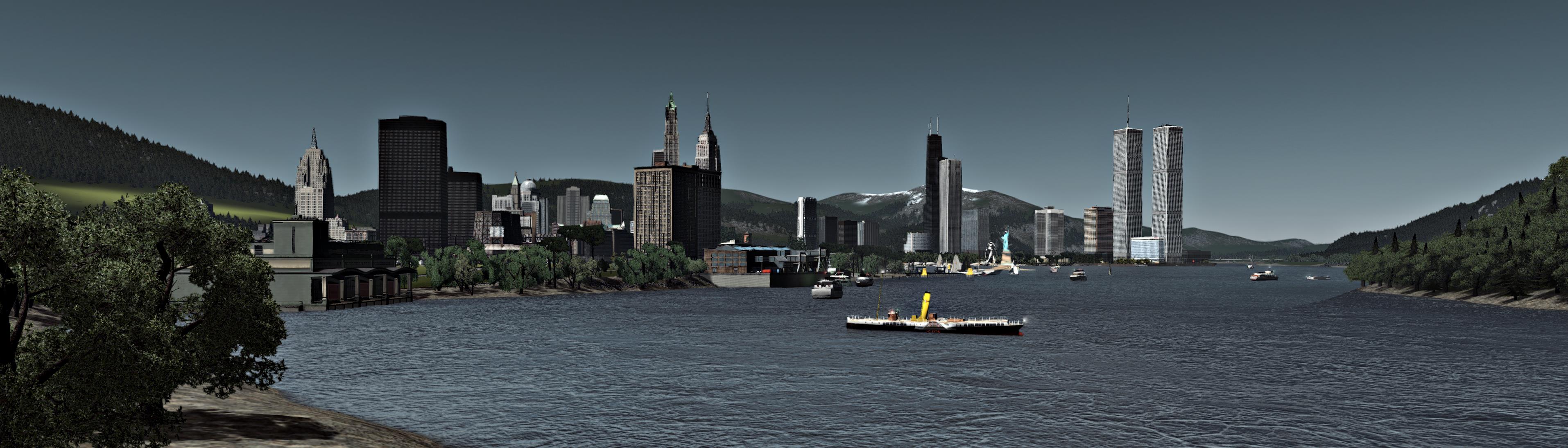
Welcome to the Republic of Modernity and the Golden Era of Art Deco Architecture! Welcome to the Rideau State's Capital Chesterfield! Greater City Population: 2.5 million, State population: 7 Million! Once a Canadian City, After the liberation of Canada (Annexation some Canadians may say) to the Greater Republic, has now become one of the biggest cities in The. Western. Republic.! Downtown has become famous for its many buildings and examples of American Progress! Downtown from the other side, Showing the great Chester Bay and the old Uptown! Downtown still has friendly people and the greatness of western culture! Newest Banking Tower for Bank of America has begun construction, will bring much-needed money and banking needs for the growing middle classes! Westward of Downtown shows the transition between downtown and midway factories! The City has become Famous for its love of theatre, such as the Regal Theatre! Uptown is also well known in Americana, with the world famous Milton Hotel! Famous Liberty tower in Uptown that has become 10 years old as of today, July 22, 1958! just south of Downtown, Hells kitchen has become well-known for its Bars and parks! The Famous Smith Tower at Liberty-Justice Intersection! Tribune Paper is the largest newspaper company of this great American City! The Great Park of Chester has become well famous for its Atlantic viewing Colm Tower and Garden! Despite the many milestones the city has made since WW2 and Western Unification, the westside Docks has become one of the worst centres of crime within the Republic! Eastern tower has become a grand hit for the local mayor and political elites, part of the city's South-East region! Famous clocktower on the Local Shoe factory has been declared a Historical Landmark by the Republic, located just south-east of downtown! TThe French City of Davison has joined the greater Chesterfield Area! Southern French-speaking parts of the city have become Famous for its parks and french lifestyles! New Building of Freedom Banking has been elected, by a Chinese Billionaire Xie, fleeing the Evil Communist of the Euroasian Soviets!!! No Commies to be found here, our city is the paradise for the Freeman and Capitalist! Just North of Downtown by the East coast has become well loved by the Republic's rich, as gated communites are common site in this part of town! Across the River is the small Tourist town of Mathews, with its famous Teapot Water Tower! South of the Big City is the city of Anaheim, Famous for its Automotive Industry and medical school! New Buildings for the poor in the Historic city are being installed by Capitalist, confirming we don't need socialist programs! West of the Big City is the infamous Caniso Town of Atlanticium, what happens in Atlanticium stays in Atlanticium! Just North-East of The Big City is the Brand New Nuclear Powerplant, Powering the Whole Great State of American Rideau! *also helps with the production of nukes for WW3* Just North of the Great Rideau River lays the Grand Manufacturing hub of Smallville, Well known for the huge tower of The Kingston Building, owned by the richest man in all of Americania, Dave Willson! Many of the Rich members of the City of Chester own factories here, as the Cold war between the Soviet Euro-Asian Union and the Western Republic has become very profitable for the nations elites! The Twin City of Smallville, New Naples has seen the instalment of the Huge Walnut Bridge along the River, What wonderful sight! Downtown Markson, just westward of Smallville as also seen an influx of the Big apple riches, with war hero's park! We have still much Nature to conquer, as the Franciscan Volcano still could erupt... Still, the Republic values her farmers, as they feed us and we would be nothing without them! God bless the Maryland Farmlands as they feed our Troops as we fight for western democracy and enlightenment vs the Tyrants of Eurasia! - 12
-
- 4
Entries - 1
Comment - 530
Views
Recent Entries
 Latest Entry
[C:S] Tornado Country scenario: The second visit
The passing of the tornado had one of the factory clusters pack up due to lack of workers, so the storage yard was relocated: The primary milling facility seems to be going strong though: Meanwhile, I'm having fun with gravel roads planning for future expansion of the town. You can also see the ground has mostly healed from the disaster: I also announced the purchase of a new plot of land east of town for further future development, not shown here. Instead, here's a bird's eye new of Pepper lake at night: At morning, everything seems to be peaceful, when suddenly the earth starts to shake... ...Or rather, sink. A sinkhole suddenly appeared and ate a section of Memorial Park. Miraculously, nobody was visiting when this happened. Repairs are in order. The hole was deemed too dangerous to rebuild on, so it's left as is: The construction of new industries has left the town in brownouts, so a new coal-driven power station is commisioned: However, this region either hates fossil power or has a cruel sense of humor, for a few minutes later... ...not again! Tornado! Tornado! Casualty report: 386 citizens. Power station destroyed, wind turbines derelict, fire and police brigade left without a home. The Plaza of the 299 narrowly survived after having one of its gates torn up (and having a car nearly land on top of the graves) After the necessary repairs, a new plaza for the fallen 386 has been constructed at the main park gate: The incident showed that emergency brigades cannot rely on a single office for a town this size, so a new set opens near the industrial area, hopefully out of tornado zone. They will definitely hate me for having to work near the landfill, though: A new schoolhouse has also been opened to promote growth and relieve pressure on Pioneer Elementary, as it was starting to get overcrowded: Pepper Lake after the second tornado: (For those curious to what triggers the disasters: the tornadoes happen twice over the span of two days, and the sinkhole occurs after you buy a second city tile) That's all for now!- Read More
- 0 Comments
- 4
-
 Latest Entry
Car Dealers
Metropolitan Ford & Hyundai Dealer MIdtown BMW & Luxury Car Dealer- Read More
- 0 Comments
-
 Latest Entry
Ep02 - The Arteries
So last time I said I was going to sketch a map of the region. I did that and it was pretty swell, too, but then I accidentally the whole thing, so now we're left without it. As in, I derped up and only saved the background: I'll redraw it soon, just couldn't be bothered right now. Meanwhile I still had my sketch to draw some highways into the region. Because I plan the entire region ahead anyway I like to build those in advance just to kinda get things going. Two highways are going to meet in the southern suburbs of Whitehaven, one of them heads northeast around the city while the other one runs from the southern border of the region to a future ferry terminal in downtown Whitehaven. The process of building these itself probably isn't the most interesting to most of you, so here's the finished product. First, the current region view, Day 1 so to speak: Yeah, they look chunky when you look at them like that, but we all know it's not really practical to have a highway smoothly waving through the countryside if you want some interchanges here and there, so... here's some of those from a little closer: A lot of parclo action and a roomy Y where the highways meet. Parclos are everything around where I live, almost all highway onramps are some variation of a parclo. I like that and I love how the NAM has evolved to be able to build them this smooth and neatly. I'm thinking I might add another interchange somewhere in the urban area and build it as a diamond of some sort though. This is the currently very barren looking end of the south-north highway: Had to get rid of that lane somehow... also, pardon the grid. And I see that bump right there... at least now I do. *facepalm* We'll see all of these again at some point when they look much nicer. So far I've decided to already dress them up with some lights and signage because god knows I don't wanna spend ages scrolling down to that stuff in my parks menu at some point in the future, so why not do it while that menu is still nice and empty... As for the terraforming, I'm going to take that step by step on a smaller scale, mediating between using the existing terrain and adjusting it for better use or aesthetics. And then of course, there's... The aforementioned signs in form of the GLR Signage Sets have gone in alongside with the outdated version of the LRM I like to use. The T21s you also may have noticed already. Along with that there's a sidewalk mod I made a while back using GoFSH and the wonderful compository by rsc. Still very nice and tidy, but now that the main traffic anchors are done road-wise, it's time to get dirty with some rail - and that means I have a couple of hours on the popular file exchanges ahead of me looking for some stations. Feel free to shoot any suggestions my way, what I've been looking for pretty desperately has been a really large central station that is not a terminus. I know Warsaw Central sort of fits that description but I'd like regular ground rail for regular ground raility purposes. If anyone has anything nice, I'm game. So next time hopefully I'll have the map back and some clunky old rail lines to show you guys. See you then! -
 Latest Entry
Chapter I: The Life in Downtown
It's a beautiful fall day, the city thrives, the streets of downtown busy, bells of the churches ring, people walk sidewalks talking on their phones, cars blow their horn, the air smells somewhat delightful. You are in Downtown Canderia, the heart of the city-state. The highrises and historic buildings create the everlasting image for you as you appear around the city, looking at storefronts, and the beauty that sits before you inside such a deep city, with it you visit the museums and get into the history of such a odd place. How could such a small city-state, survive being surrounded by the United States and Canada? Why has it never tried to join Canada, which acts diplomatically like it's sibling, it's brother? This place is rather strange, it shouldn't exist but, yet it does. The national flag of Canderia, which has been in use since 1833, but Canderia itself has been a British colony since 1598, older then Jamestown and other colonies in what would become the United States, it was a hugely important city for the British to keep especially during the Revolution, as it was a firmly British loyal city, defending itself from the Continental Army, it was given the best treatment from Parliament before, during and after the revolution, as it was not considered part of the 13 Colonies but instead as its own separate entity separated from the 13 Colonies. Though the flag itself, represents the War of 1812, when 2,000 American soldiers tried to siege the city from the British, the city only with 150 men, fended off the American forces with help of its heavily not passable Canderia Mountains, it is more of a feat when you realized only 95 of the 150 soldiers, had guns. The historic Canderia Summer Palace, today a museum and no longer used by the Windsor family, but remains a very popular tourist spot for those visiting the Commonwealth. Those this is where today, and since 1887 the Commonwealth has gathered with independence in 1925 it became Parliament Hall, before hand it was the Colonial Palace. It sits on the iconic downtown surrounded by modern and classical highrises, historical buildings, and many parks of the city. The historic Canderia First Bank Building, still in use by CFB today. The historic Customs House & Market Hall near the waterfront This is the historic Royal Hotel, where many world leaders stay at. It is 50% owned by the government, and the other 50% is owned by Canderia Royal Lodging Corporation. The National Hall of Canderia, home to the National Museum and Library, built in 1933, and is a major spot for tourists as it includes war pieces, as well as the stories of those who served in the world wars and old WW1/WW2 Equipment on display in the museum. Then on the opposite end, those who are Anglican can not threat with Saint Andrew's Cathedral, Canderia, in the historic core area of the city. Here is the city's Catholic cathedral, Roman Cathedral of Nativity of Our Lord, built in 1901. Here in downtown, the first picture sits the Debenhams Department store, built in the 1960s, and continues to remain open in downtown as a very high tourist and popular department store. The second photo is the old Staudenmaier Department Store, though the department store itself closed in 1997, the building remains standing flying a Canadian flag as at one time the top floors was used as the Canadian embassy and the flag remains today as a reminder of Canderia's closest ally, Canada. Though today, the largest retailer in Canderia is Kmart. You're thinking "What but Kmart is dying." Yes, in America. In 1993, Kmart's Canderia subsidiary broke off from the company to form the Kmart Corporation (Canderia), and it remains the largest retailer in the country. This is the Kresge Building (the blue building), the headquarters for the Kmart Corporation built for them in 1975, today Kmart Corporation remains far ahead of Walmart who struggles with outdated stores with high pricing, as well as struggling to win over customers with their reputation in America heavily known, Walmart entered Canderia in 1988 and has heavily struggled with it and other retailers in the country. The logo for the Kmart Corporation Debenham's Department store located across the Canderia National Police Headquarters Of course while you're in town why not catch a ballgame at Kmart Field? It's home to the best, and only MLB team in the country! One of two outside of the USA with the Toronto Bluejays! The Canderia Ducks! There is also near it is the famous CCBC (Canderia Commonwealth Broadcasting Corporation) Stadium, home of many events and concerts & FC Canderia. Of course near it, is one of the most important and historic universities in the Commonwealth, McPherson Methodist University named after Edward Genes McPherson who in 1798, brought Methodism to the colony, and when the Methodist college was established in 1833, it was named in his honor. Though, those who do not have the desire to learn the Wesleyan way, will often attend National University of Canderia. A much smaller scale university but still a very efficient and highly ranked among universities across North America. The conclusion but not forever, as we will travel out downtown and see suburbia and the great stoutness that this city-state holds outside the downtown. -
-
 Latest Entry
Municipality of Tamban: Build Update #1
I have already started the construction of the municipality of Tamban by creating five major roads: The National Road, Tamban-Mayantoc Road, Tamban-Murillo Road, Giputlan Inner Coastal Road (an inner road), and the Tamban-Daraitan Road Furthermore, I've added more inner roads to form vilages. So far we have created 4 villages: Giputlan, Laroja, San Fernando, and Sta. Cruz. Finally, I added streets to these villages. That's all for now. See you on my next update.- Read More
- 0 Comments
-
- 7
Entries - 42
Comments - 2793
Views
Recent Entries
 Latest Entry
North Downtown development
The neighbourhood of North Downtown continues to grow economically and urbanistically as you can see by a short visit to the northern part of the city business district. North Downtown is separated from its southern section by the municipal canal. This dynamic neighborhood focuses primarily tertiary activities while being more residential than the southern part of the Downtown. This year has resulted in a particularly strong urban development around the old docks which are being converted into a residential sector. Have a nice visit ! Aerial and night views of the neighborhood of North Downtown The northern section of the business district was later urbanized than the historic southern district at the end of the 19th century. However, this neighborhood adopts the same checkerboard urban plan as the rest of the downtown. Constructions were sporadic until the beginning of the 1950s and logistic and port activities only left the area late. The urban spaces bordering Lake Omega have been the subject of a major reconversion to the residential sector. Aerial and night views of the neighborhood of North Downtown This year ends the main phase of the project to convert former docks into residential and commercial areas. More than five years of work were necessary to break through the new marina and complete residential buildings that adopt a resolutely contemporary architecture. The neighborhood also has several sports fields and a school. Aerial and night views of the neighborhood of Honeguas Park The recently completed renovations to Honéguas Park have revitalized this historic park, which delineates the neighborhood to the north. The park has undergone major revegetation while street furniture has been modernized. Aerial views of city's most iconic skyscrapers - 7
-
- 14
Entries - 5
Comments - 1506
Views
Recent Entries
 Latest Entry
The final photos
These are likely to be my final photos of this region, though I might post something if I hit 12 million. The issue is that it's taking a very long time to load in the cities due to how many mods and BATs are in these cities and on my computer. Enjoy these last shots of the region. Current population is at 11.9 million, and is reaching its max population for only half the small map. You might notice that the population jumps up 200k in the first screenshot, that's because I went in and did a rehaul on a failing city in between screenshots. - 14
-
- 11
Entries - 0
Comments - 450
Views
Recent Entries
Future map of the city.- Read More
- 0 Comments
- 11
-
- 3
Entries - 0
Comments - 377
Views
Recent Entries
- 3
-
- 5
Entries - 2
Comments - 434
Views
Recent Entries
 Latest Entry
Edmonton international Airport.
Here is the city’s international airport. From here it will take you to most major cities globally. It’s the busiest airport in the northeastern Region. Plans for expansion are underway, building a new runway parallel to the existing runway and also a new terminal to host the 747 & A380 to reach even further destination to boost business. - 5
-
- 4
Entries - 24
Comments - 920
Views
Recent Entries
 Latest Entry
Update 4 - October 2018 Census
Replies are at the bottom... Prologue The Kellan Metropolitan Area, sitting on the Eastern Coast of Vancouver Island at the south end of the Discovery Passage, has went from being a small fishing village, and the former site of multiple winter resorts, to one of the most prosperous cities on the entire North American continent even though it is nowhere near being one of the biggest. While the region's population boom that commenced in the early 1980s did come to two abrupt declines, one due to the Great Recession and another due to the 2013 floods, the region's population has since started skyrocketing again- gaining over 376,000 people since 2015. As with all other population booms, Kellan's has introduced a great shift in demographics causing a valley once dominated by agriculture and dubbed the "Salmon Capital of the World" to now be referred to as the "Silicon Forest". Obviously, the boom can't last forever and it is in fact expected to peak in the 2020's before finally coming to a halt, but that still feels like forever for the residents who already live here and have to deal with the aftermath... Blank shot of the region Blank shot of the region's transportation network Image of the region showing all city limits and their respective subdivisions. All the freeways and highways of the region, now updated with the latest progress shot of the region An updated version of the regional light rail map, now much more detailed. Density heatmap of the region, highlighting the unusually high densities of the Business Triangle* (and to a lesser extent, Sapien) that, while considered normal in some places of the world, are very parallel to the sprawly neighborhoods full of single-family homes and/or low-rise apartments that most people on the North American West Coast are used to. *The Business Triangle, which is highlighted by the highest density area (Purple color) in the North Valley, consists of Radiation and the Downtown, Lakefront District, and Gresham areas of Kellan. While West Chandler is officially considered a part of the Business Triangle (despite the fact its inclusion makes the Business Triangle no longer appear as a triangle), West Chandler is a bedroom community which makes most people exclude it from the definition of the Business Triangle. Things to note about West Chandler West Chandler's extremely low median age, rent, and home prices (and even income as shown in the chart at the bottom) can be explained by the fact that the city's municipal government has enacted a series of laws and programs in the mid and late 2000s that have turned the city into what many now refer to as a "Youth Paradise". The city's rent control is incredibly aggressive, with even the seemingly luxury residential towers in the western part of the city still being made up of mostly affordable housing units populated by young (and presumably, poor) residents. More will be explained more in a future update dedicated to West Chandler as the story of how West Chandler became what it is today is quite interesting. Population chart highlighting the fast growth of the region with the metropolitan area gaining over 1,170,000 new residents between 2010 and 2017, that's an average of over 167,00 people per year! The City of Kellan itself has gained 186,907 people since 2010, it may seem like a lot but is much lower than the 570,000 people who moved into the city between 2000 and 2010, which is due to the fact that the region's population boom was offset by the Great Recession and the Great Flood of 2013. While Kellan's economy bounced back quickly after the first event, the second started a chain reaction of factors that led new residents to seek growth in Kellan's suburbs despite the fact that, at the time, rents and housing prices in Kellan were exceptionally cheaper as supply far exceeded demand until only recently. Same chart as above, only the City of Kellan is excluded to better visualize the growth of other cities in the region that was not well shown in the previous image due to Kellan's disproportionate population size. This is an income chart showing the Median Household Income, Median Family Income, and Median Salary that I included simply because I couldn't fit it into the individual city images above. Replies Seppi93 | Yes I did, and thank you. Took a while to make but the ending result was pretty great vaughanwiliams | Thanks, and not very. Sometimes when I have maps with a lot of trees it might go a little slow (which is why, as you can see above, there are some unfinished city tiles that have zero trees) but other than that the only time I truly notice is the long load and save times. Thanks to SC4 Launcher, however, I still don't really have to worry about mods that much. kschmidt | Thank you, it's a shame not that many people know the University of Clayhurst exists, it is light years better than the in-game university. And the little car traffic is simply because the in-game mechanics prevents people from traveling between more than one city tile. In real life, the streets would likely be filled with cars trying to either get to the freeway from other tiles or trying to get to the Business Triangle. T Wrecks | Yes, I've been aware of the Maxis repetition in lower density commercial and it often ruins a lot of my photos. While I do care about it I've hesitated from downloading additions and alternatives due to the fact it doesn't seem to solve my repetition problem as they seem to always overtake Maxis buildings. It's the same reason I always set R$ and R$$$ tax rates to 20% so only R$$ can grow, middle-class residential lots not only obey zoning sizes but also aren't repetitive, both unlike R$ and R$$$. It's probably just a problem with my game (or a mod problem) but that is why I still use Maxis commercial despite hating it so much. kingofsimcity | Yes haha. It's a pretty notable feature of big American and Canadian cities to have certain major arterial roads with high-rises, and sometimes skyscrapers, in low-density neighborhoods. compdude787 | To be honest, that interchange was originally built the wrong way which is why I was so careful to not show it in any pictures. When it's fixed I'll show it in a future update citybuilder234 | Photoshop. Lots and lots of photoshop. waybig | It is a model of the real-life YouTube Headquarters in San Bruno, CA by the great mattb325, which can be found here. - 4


-
Recently Browsing 0 members
No registered users viewing this page.
-
-
-
City Journal Statistics
-
Total City Journals3,961
-
Total Entries22,822
-
-
New Entries
-
-
Recent Comments
-
 That's a lot of industry! Im curious, where are the commercial zones in the city? I couldn't spot them.
 -

By ilikehotdogsalot · Posted:
Lovely airport! Nice to see Pan Am made a comeback in your city! -

-
-

By Tyberius06 · Posted:
Very cool images and nicely designed airport! Great work! -

-
-
those patterns are really cool! You're a patient planner. congrats!
-
 Can't remember what I voted last time. I think it was a few farms. Anyway I'll go with SAND DUNES today.
 -

By justforfun · Posted:
Ploppable textures would amazing! Meanwhile I also made a small set of S3D fillers. Of course they don't work so well on slopes, haha.
-


