

-
Welcome to Simtropolis!
A community dedicated to SimCity 4 and all city-building games. (About Simtropolis)
-
Announcement
-

Simtropolis Returns! 05/26/2026
See here for details about our site recovery efforts.
-
 Supported
City Journals
Our community City Journals
-
 Latest Entry
ACERENZA
ACERENZA Acerenza is an agricultural town This city is crossed by a beautiful river Of course there is a small lake where two rivers join. These rivers run through farms The city has a very old style. The train station also has the traditional style The heart of the city has a beautiful church with a large square The city also has somewhat modern commercial buildings This city passes a highway and there are some exits The night comes and the city takes on another aspect The church has another look at night The night is deep and the buildings have different colors with artificial lights COMMENT REPLIES: Sambuca @TheMurderousCricket Thanks for the comment @AP Thanks for the comment. Your mods for the beach are already there. Those beaches are MMP but you can see them in the next updates or if you are in the discord server of SC4D and Simtropolis or on reddit then you can already see the images @Dreamcitybuilder Thanks for the comment -
 Latest Entry
The beginnings of a new downtown
The scene was set. Raccoon City would begin a new life here and now. The mistakes of the past have long been erased or forgotten. Umbrella first started out by clearing the land to lay down the interconnected streets of what will become the CBD. This new downtown will eventually be filled with gleaming new skyscrapers, high end shopping and retail, and multi-millon dollar condos. The Umbrella Corp had already attained a variety of multi national corporations and high end shopping names to be housed in the city. What they promised them is unknown even to some of those within the highest ranks of Umbrella. But they have already purchased their plots within downtown and began construction on their new buildings. The Raccoon Promenade...home to some of the most expensive retail and hotel rooms in the city. This is where the wealthy will be mostly spending their evenings and weekends after what they consider a long day. Eventually high rise condos and office towers will be built around the district. So for now Umbrella takes a step back and looks over what they have done, and are proud of themselves. People are becoming more optimistic about Umbrella's plans for the new Raccoon City. Umbrella also has plans for state of the art schools, single family suburban homes, and a safe, healthy, and happy metropolis. Or at least that's what I'm paid to say. So again we at Umbrella welcome you to Raccoon City. We hope you have a safe and enjoyable stay with us. -
- 4
Entries - 21
Comments - 758
Views
Recent Entries
 Latest Entry
Singapore (Part 1)
Welcome Back to my City Journal, "Touring the World"! All Cities shown are inspired by reality, but may have subtle differences with their real-life counterparts.
These differences may be due to game constraints... being in a Mirror Universe... or... just because. For this entry, we'll be visiting Singapore! SINGAPORE, a clean, safe, efficient and wealthy city-state located on an island in hot and humid Southeast Asia. Built on the tip of the Malayan Peninsula along the Strait of Malacca, it is a major trade, finance, shipping and tech hub and a popular tourist destination. The country (and the city) are built on a relatively small land area sandwiched between two much larger countries, Malaysia to the north and Indonesia to the south. Despite its small size, the country is the most developed economically in Southeast Asia with a standard of living that is among the top ranked in the world. It is home to many international businesses as well as first-class education, research and health facilities. Its infrastructure is also amongst the best in the world. We begin by flying over Singapore. Here we see Singapore's Central Business District (CBD), the Marina Bay area, Sentosa Island (a resort island located south of the Singapore "mainland", where many Singaporeans spend their weekends) and some of the other surrounding areas. And now let's begin our day in Singapore! First sunrise along the Singapore River which runs adjacent to Singapore's CBD. Usually at this hour it is fairly quiet with the only activity being morning joggers getting their exercise routine in before the weather gets too hot, though even at this hour, its usually around 80-85'F already. As the day progresses, Singapore's CBD gets busier, bustling with office workers toiling away for both locally-based companies as well as major international and global corporations, especially in the areas of finance and banking, which has traditionally been a key industry of Singapore's strong economy. Local banking corporations such as United Overseas Bank (UOB) and Oversea-Chinese Banking Corporation (OCBC) are based here. In addition, many global banks such as ANZ, Citibank, Standard Chartered, HSBC, JP Morgan, BNP Paribas have regional headquarters in Singapore's CBD. In the last decade or so, an ever increasing amount of global tech firms have also moved into the area, including the likes of Google, Apple, Samsung and ASUS. Along the Singapore River is Clarke's Quay, a very popular dining and nightlife destination for both tourists and locals. Many restaurants and bars line the river and these businesses are operated in traditional Singapore "shophouses", a type of colonial-era architecture unique to Singapore, Malaysia and parts of Indonesia. Drop in here for some amazing seafood, or a nice cold locally-brewed Tiger Beer, or perhaps something stronger...?
Near the CBD is Marina Bay, home to the famous iconic landmark Marina Bay Sands Hotel & Casino, with its "surf board" infinity pool connecting the tops of three hotel towers, and Gardens By the Bay, a 250-acre nature park. Both Marina Bay Sands and Gardens By the Bay were built on re-claimed land. And now let's take a short diversion to Sentosa Island, where Singapore goes to play and spend its weekends. The island features beaches, two world-famous PGA golf courses, some historical landmarks and some of the most expensive neighborhoods in the world. We'll visit some of these areas in Singapore: Part 2, but for this entry, let's visit Resorts World Singapore, an integrated resort on Sentosa Island and the island's biggest tourist attraction. Resorts World Singapore features a hotel, casino and mega-mall as well as Universal Studios Singapore. An overview of Universal Studios Singapore. Although not as big as the ones in the United States, Japan or China, it is the only Universal theme park in Southeast Asia and is quite the popular attraction. Some of the more popular parts of the park are Jurassic Park, Springfield and Transformers: The Ride. The park can be accessed by road (the massive car park is located underground beneath the park itself - see if you can spot the ventilation shaft), monorail (followed by a short tram ride to the main entry area) or by foot through an air conditioned, semi-covered water-front "moving walkway" that connects the Resort with Vivo City (a mall on the "mainland") and the cruise ship terminal (also on the mainland).
Revenge of the Mummy, located in the "Ancient Egypt" section of Universal Studios. A roller coaster, with you guessed it... mummys! Glass covered stage area for shows, Nickelodeon Nick Toons and Mel's Drive-In Diner. The main park entry area featuring the famous "Universal Globe" that is present at all Universal theme parks around the world, as well as the construction site of the park's first major expansion since opening. If theme parks aren't your thing, perhaps some shopping along Orchard Road, Singapore's high-end and exclusive shopping street, home to many top of the line designer brands. One of the more unique buildings is the pagoda-inspired Tang's Plaza, located at the intersection or Orchard and Scotts Roads. The base of Tang's Plaza is home to the flagship store of TANGS, a locally based high-end department store that sells everything from apparel/clothes to kitchen-wares and home goods. The top floors are occupied by the Marriott hotel. Another view of Tang's Plaza as well as an ERP (Electronic Road Pricing) toll gantry. Singapore was one of the first places in the world to implement electronic-only tolling on its roadways. Singapore's CBD is also subject to "congestion pricing" where tolls vary based on time of day and demand. Given the lack of space, Singapore's government has encouraged its citizens to use public transit as opposed to driving. Unlike many western countries, Singapore's public transit system is top notch, clean, safe, efficient and always on-time. Taxis in Singapore are also relatively affordable when compared to other countries and taxi operators are governed by strict rules that ensure trustworthy and honest drivers and clean and safe vehicles. After a long day of touring Singapore, its time to get some dinner. A popular spot is East Coast Seafood Centre, located in East Coast Park about half way between the CBD and Singapore's Changi Airport. Here you will find famous local restaurants such as JUMBO Seafood, Long Beach and others serving the famous Singapore Chili-Crab. Each restaurant does its own take on the dish, so its worthwhile to try them all. The restaurants are housed in open-air buildings and the tables are mostly located outside and along the water. A perfect atmosphere for seafood and beers! How about an after-dinner swim? Let's return to Marina Bay Sands and check out the world-famous infinity pool with its sweeping 53rd floor views of Singapore's CBD. And that wraps up our day in Singapore! Good night and we will see you again soon for Part 2!
Thanks for visiting!
You can also follow my CJ's and other content on Instagram. - 4
-
 Latest Entry
Evora 'Oblast'
At the north of Magikistan growed Evora, a modern business centre, developed whit help of the railway connection between Yheza and neighbours Nation. Huge quantity of fossil fonts transit trought this way for supply energy for all City of Magikistan. City center by night... ...and by day... The commercial zone... ...and railway station... Also in Evora there are old residential blocks built in soviet era... Gas power implant on the South, supply electricity for Evora Oblast. -
- 284
Entries - 3253
Comments - 106029
Views
Recent Entries
 Latest Entry
A Trip Around The Globe
Today, we'll be taking one more epic trip around the globe and taking a look at a few of my favorite destinations and some final pictures that I began in 2021 but only finished up recently. I've spent the first few months this year working on completely new custom made terrain mods, custom made BATs, lot editor textures (which you'll be seeing in the pictures below), FSHs, and more to compliment existing custom content - I hope to bring a handful of the planet's most amazing scenes to life. -korver - 284
-
- 4
Entries - 5
Comments - 415
Views
Recent Entries
 Latest Entry
Advancing … towards the stars … maybe … ?
The Egalitarian Community The Egalitarian Community expanded their infrastructure in several directions. Infrastructure for Engelberg Traffic Jams and overcrowded roads proved to be a major challenge. The following traffic jam severely disrupted the economy of the town. To improve the export of fuel and bitumen, a new oil harbor was constructed. Shortened ways, and oil transport ships should reduce road traffic. Pipelines directly connected the oil harbor to the refinery. Additionally a harbor to export manufactured goods allowed the export directly from Engelberg to the world markets. Constructing these harbors was somewhat dangerous. Workers feared, that their vehicles could fall into the sea ... A small car manufacturer and a mechanics workshop allowed further self sufficiency for Engelberg. However the small size of the car manufacturer limited the output significantly. To protect the harbor against potential royal claimants, several guns where placed at the coast near the soccer stadium. Not everyone was happy about that ... For emergencies and technical assistance several helicopters where stationed near the town. Bratwice jewel of the coast The village of Bratwice was largely overshadowed by Engelberg. Economic planners visited the area to asses the economic potential, and discovered some marvelous beaches. Therefore it was decided … Bratwice should become a recreation and tourism area. Large hotels emerged near the passenger harbor. A zoo and several attractions entertained the tourists. While getting a population high enough to remain an independent municipality, Bratwice still remained the smaller neighbor of Engelberg. At the center was the "Consum" supermarket. Most hotels where as close as possible at the coast. International Tourists arrived mostly by the sea. The Egalitarian Community bought several luxurious passenger ships Some guests played the latest video-games in the Arcade, a small cooperation project between the Egalitarian Community and the Futurists. Other visited the zoo or took a bath in the hot water .... Clearly Bratwice became a magnet for tourists ... But the original small village remained at the outskirt, reminding of the past To the East of Bratwice was the Knighthood of Studzianki, a small village ruled by a arch-traditionalist knight … Therefore the border was heavily guarded to prevent any intrusion. The tunnels and the prison To expand into the east, several roads had to be constructed. The difficult terrain and the hills resulted in the construction of two large tunnels. The police stations where overwhelmed with convicted criminals. As a result, the council decided upon building a central prison in the countryside. Several layers of walls and protective measures should prevent escapees. Prisoners worked at the nearby pig farms to produce some meat.
While previously the Security depended upon a militia and police force, now a professional army was raised. Two bases for the infantry forces and their tanks, an artillery base at the harbor of Engelberg and the new naval base showed some military capabilities. The Base close to Engelberg ... And the base close to Barachnia and Solidarity ...
The Naval Base near Engelberg hosted 3 battle ships and 3 submarines
Railway export To reduce road traffic, a railroad connected the textile factory at Solidarity with the border. Gradually more and more goods where loaded here, and later exported abroad. Barachnia Barachnia was a medium village on a crossroad. Due to the high strategic importance, the modernization and expansion of Barachnia started as soon as the necessary infrastructure was in place. To the north of the old village, a new city center with large residential buildings emerged. Chemistry goods had to be imported until now. The new development plan called for the construction of a chemistry industry in the mountains in the North. The area was directly at the borders to the independent town of Rzedovice. A small fence was the only separation While the Chemistry Industry in the North fulfilled the domestic demand, further chemical production could increase the export revenue. Therefore another chemistry factory was constructed in the south, accompanied with a plastics factory. Some chemical goods where exported to to the textile industry in Stahlberg. Behind these buildings was a bakery to supply the region with fresh bread. This location was chosen due to availability of some oil in the ground below. Some people demanded the introduction of personal cars to show the new wealth of the Egalitarian Union. However the democratically elected council made a fundamental decision against personal cars. Personal cars are a symbol of elitism. Egalitarian Citizens should use public buses and maybe trains in the future, and shouldn’t clog the streets. Symbols of individual status could create classes and class divisions …. While the Egalitarian Union now strictly opposes private car ownership, other fractions where clearly more open to individual traffic. Here is a map of the main economic developments of the egalitarian union. Only the most important industries are shown with their own symbol
White = Foreign Territories Green = Nature and Border regions with minimal infrastructure Dark Blue = Government Institutions, Harbors, Military Installations, Heavily guarded border areas Red = Modernized Civilian Settlements Light Red = Transit Roads and areas with special agreements with other Fractions Orange = Non-Modernized Civilian Settlements Yellow = Large Farms Purple = Industrial Areas Light Blue = Streets with some Infrastructure, Depots The Futurists and Scientia
The Futurists where a global community of scientists, researchers and visionaries. They hoped for a new place to unshackle the power of science. However many towns and countries restricted their research with censorship and regulations. The futurists gathered some money, and further attracted investors to promise huge returns of investment with large high-tech enterprises. Scientia was born! Build on the green fields, the town had characteristic high-rises and a railway network. The center of the town was a large train station. The futurists hoped to connect their small local rail-network with the large world. However many of them preferred to travel in private luxurious cars to show their status. Most people lived in several high-rises. The Hospital had several helicopters and was open to all people in the region who needed help by high-tech medicine … The Scientific Council had a high-rise as their headquarter (blue arrow). Directly next to it was a television studio (green arrow), the university library (yellow arrow) and the university tower (red arrow). The "High-Church of Science and Enlightenment", a heretical sect of the original mainstream church, which embraced trans-humanism established a church and an orphanage in the town center. The scientists hoped to trade with all fractions. They had to repay some loans and hoped that the export of computers and technical gear could give enough liquidity. The Egalitarian Community entered negotiations with the Futurists. Some territory was transferred to them to form a “Special Economic Zone”. The High-tech industry there should mainly produce computers for the Community.
A second computer factory was established in the South. Rare materials where imported from the Egalitarians. The future looked bright. Now the Futurists could begin researching towards building advanced rockets to fulfill their true desires. SPAACEEE!! Rzedowice, trade and development in a small and independent town
The town of Rzedowice was barely more than a village in the old days. They rebelled after the fall of the kingdom and banished the tyrannical knight who previously ruled over the local land.In comparison to Stahlberg, the town lacked the population to seriously thinking about becoming an industrial powerhouse. Challenging the Egalitarian Community was not a possibility.Instead they tried to preserve their independence by becoming a valuable trade partner. A treaty was negotiated with the Egalitarian Community. The town allowed them to maintain a transit road trough their territory, if the Egalitarians in return would maintain their roads and construct a bridge over the transit road. Special transit posts controlled the entry and exit into the transit zone from the Egalitarian Community Agriculture and Textiles became the main industrial goods which where traded with the Egalitarian Community and the Futurists. Electricity was mostly imported from the Futurists due to their advanced and cheap power generating technologies. A small dock allowed ship-travel. However it was rarely used Some citizens rumored, that the mayor tried to overcompensate the relative lack of power and population with oversized flags and flagpoles in front of the city hall Diplomatic Relations With the industrialization, the trade between different towns and villages increased drastically. Tourists and travellers crossed multiple borders on a regular basis.
To better regulate the flow of goods and people, different fractions constructed embassies with each other. Often grouped next to each other, and the host government, these buildings became hubs of diplomacy and espionage.
The embassy area in Engelberg was rather conventional. Even Rzedowice spend some money to construct a small embassy. The Embassies in Stahlberg annoyed their host city with large propaganda posters. While the Futurists praised the potential of space travel and computers, the Egalitarians promoted their model of society ...
While Rzedowice was rather small, it was at a vital strategic position ... therefore several embassies of foreign fractions found their place here Stahlberg and the “Bridge of Friendship” To drastically reduce the travel time to other industrialized towns, the government of Stahlberg negotiated a treaty with the Scientists of Scientia. The “bridge of friendship” should be constructed across the river. The bridge should be high enough to allow smaller ships below it. However such a big project might take some time. The reality was that travelers still had to take long detours ... Elites in the city moved to the outskirts and preferred large mansions A public pool became the new main attraction Meanwhile some farms added solar panels to reduce their dependency on the power network.
Due to the increasing industrial power of the Egalitarian Community, Stahlbergs government became more wary. Here are several tanks parked directly behind the city hall. Just to prevent any rival from getting bad ideas ... Two additional small infantry companies where raised and stationed around the town. State of rail development Only 2 railway networks existed. The large railway network connecting Scientia and her industrial hubs, and a small railway for the export of goods near Solidarity. Planners dreamed about larger railway projects to actually connect towns and villages with each other. The “red rail” was proposed in the Egalitarian Community. Meanwhile economists of Stahlberg hoped for the “green rail”. Both plans together would connect the most developed areas. The Isla de Luna The Princess faced new challenges and improved her power base. A lumber yard and a furniture factory became the industrial hubs of the island. Workers at the furniture factory should see every morning the glorious statue of her royal highness However an erupting volcano seriously threatened the island. A fire on the royal museum was barely extinguished. Was it the volcano, or was it sabotage? Anastasia certainly had to implement stricter security over her subjects! To further dominate her subjects, she build a prison and a labor camp. Conservative Clergymen, unhappy with the Egalitarians and the heretical trans-humanists in the new futurist city found a new home at the Cathedral. Garbage treatment wasn’t really advanced here ... Princess Anastasia was unhappy upon hearing of the emerging Egalitarian Navy. She ordered to send spies to the mainland. Clearly ruling this small island was not enough for her
Space Programs The Scientific Council took over the small Astronomic Society. Now the dreams of space travel could become a reality. In difficult negotiations, they convinced the Egalitarian Community and Stahlberg to cooperate in a small space program and build new rockets and spacecrafts. The goal of the “Common Orbital Program” was to reach a stable orbit with a manned spacecraft, and to deploy basic communication satellites. One of these satellites should have the ability to shoot photographs of the home region. The first stage was a series of sub-orbital crewed mission. The C-1 mission deployed a small spacecraft on a suborbital trajectory. However scientific instruments didn’t survive the atmospheric reentry. The spacecraft and its astronaut splashed down in the ocean. Egalitarian Ships rescued the astronaut. # Two of the moons of the main planet where visible during the launch .... The view from inside the capsule was spectacular. For the first time, a human had seen the curvature of the planet with their own eyes! The C-2 was an improved mission based on C-2. The spacecraft however failed to establish a stable orbit and remained on a suborbital trajectory. Orbital reentry is always dangerous ... but the capsule luckily survived the high temperatures. The Space Program lacked strong enough engines to actually reach a stable orbit. Further research and funding became necessary to archive the goals! ----------- And now to the main map after the chapter ....- Read More
- 0 Comments
- 4
-
 Latest Entry
Cuidick Metropolitan Area I
Cuidick's skyline, the capital city: Famous for its parks and green boulevards, caughts the visitors attention because it seems always so calm for a big city. You can always go out for a walk or a nice cup of tea in the historical centre. Eastern Cuidick and the sobriety of the royal palace: It's one of the traditional neighborhoods of Estrande and, in instances, it even looks stuck in time. That hasn't averted it to become a hub for hipsters and high fashion fans though. It's currently one of the most desired places to live among young people. And why not, as long as you can have a good time in the fancy shops or in the community farms being an ecological saviour. It's always a good time to play football. Augusta Proxima, the Estrandish suburbia at its finest: Having kids and cannot afford the astronomical prices of those trendy flats in Eastern Cuidick? You probably want to move to Augusta Proxima, an idilic non-stop serial housing neighbourhood in Western Cuidick. Don't worry, this is Estrande, you can leave your car at home, take the train and get to the supermarket within 15 minutes! That's all for today. Greets! -
- 2
Entries - 2
Comments - 228
Views
Recent Entries
 Latest Entry
Charleoix City Highway Reconstruction Act
Greetings, The second installment in this series covers the Charleoix City Highway Reconstruction Act, which provided 1,000,000 Charleoix Francs (10 Charleoix Francs=1 Simoleon) to shovel-ready projects designed to reconstruct several highways and their interchanges to reduce traffic jams and upgrade outdated sections of highway to modern standards. Project 1 Charleoix Highway 2/301 Interchange At the core of the Charleoix highway system are the 3 mainline highways-- highways 1,2, and 3. Charleoix Highway 2 connects Charleoix City and the commercial powerhouse of Luxaco. Charleoix Highway 301 bypasses Highway 1 as it turns East/West to follow the Cross-City Expressway through the capital. The interchange between Charleoix Highway 2 and 301 were originally constructed using a mixing bowl style interchange that also provided direct access for the nearby factories to the highways: While these mixing bowl style interchanges work well in moderate-traffic environments, due to the development of an industrial zone in the southern suburb of Maple Park, this interchange has become congested in several locations, so the Charleoix Ministry of Transportation elected to rebuild this interchange to a more standard 4-leaf clover configuration. Initially, eminent domain was used to purchase and then bulldoze many of the surrounding factories, and a temporary power line was constructed to allow transmission of power to continue uninterrupted. To allow for rapid construction of the interchange, detours were set up using the other highways in Charleoix City. While construction crews began to prepare the site for the construction of new flyovers and ramps, another team under the direction of the Charleoix Ministry of Forestry and Environmental Protection relocated a series of air pollution control devices that were in the way of the new interchange. The final location of the air-pollution control arrays. Once that was done, crews began to construct the inner cloves of the interchange. Great care was taken to minimize interruptions to the local roads Next, a few additional factories and commercial buildings were bulldozed in order to make room for the outer flyovers of the interchange. The Charleoix Power authority then came in and restored the high-voltage transmission grid to its original configuration, while members of the Office of the Mayor of Charleoix City re-zoned the freed up land so that new factories and commercial buildings could be built. Road construction crews also extended Denis Ave, to provide an additional access point to this industrial area. Once those projects were finished, this area was ready for re-development. Coming in at 550,000 Francs, this was by far the most expensive project included in the Highway Reconstruction Act. Project 2 Charleoix Highway 1 and 47 Interchange Charleoix Highway 47 cuts an East-West course across the northern section of Charleoix City. It provides easy access to the Obulu Champignon International Airport, before traveling into the suburb of Aix en Charleoix. While this interchange is not heavily trafficked, it was built using a highly space consuming, experimental design. Additionally, one segment of a flyover was not properly aligned by the original construction crew, leading to many accidents and reduced efficiency. While the previous interchange required a complete shut down in order to complete the work, most of the prep work for this interchange was completed while it was still open, and it was shut down in quadrants, in order to minimize the number of affected commuters. The finished Northern segment of the interchange, which a significant amount of space freed up for commercial development. While upgrades to the Southern half of the interchange were constrained by the nearby Michaud Charleoix I Memorial Park, the interchange was still able to be rebuilt to modern standards. Once the interchange was finished, road crews realigned De Paul Boulevard, and built on and off ramps connecting the "Interludes" neighborhood to Highway 1. While the road crews worked, City planners from the Office of the Mayor came in and modified local zoning to better use the newly freed-up space. Once everything was complete, this project's final budget came in at 200,000 Francs. In the not too distant future, the Ministry of Forestry and Environmental Protection will come in and reforest the innermost segments of the interchange. Project 3 Charleoix Highway 7 and 2 Interchange While its not a Mainline Highway, Highway 7 is one of the most important highways in Charleoix. It connects the seaport at Port Champlain in the Northwest to the densely settled Champignon River Valley (Northern Suburbs of Charleoix City), Charleoix City, and the Southeastern-most communities of Charleoix. Due to the number of commuters and freight trucks using it on a daily basis, the Southern segment of Highway 7 in Charleoix City has become congested, necessitating that it is widened from 6 to 8 lanes. Luckily, the highway was built for modular widening, so minimal sitework was required to widened the highway Once widening was completed, 2 of the on/off ramps needed to be reconnected to Highway 7. While the widening project was finished in Charleoix City, crews were also working on widening Charleoix Highway 7 in the neighboring suburb of Upper Gauley. Before widening Reconstruction of the Northernmost onramp to Highway 7 North in Upper Gauley Final product. Once all work was completed, this project cost 150,000 Francs Project 4- Feasibility Study of Reconstruction of Priority Corridors A,B,C The final tranche of funding from this Act went towards feasibility studies for 3 heavily congested, non-freeway corridors that carried traffic entirely within the city. Unfortunately upgrading any of those corridors would have required displacing thousands (if not tens of thousands) from their homes. Options for the expansion of mass transit are being explored, but because that is outside the scope of this act, those projects could not be completed. - 2
-
- 23
Entries - 121
Comments - 3791
Views
Recent Entries
 Latest Entry
Wade City: Overview
WADE CITY: OVERVIEW Welcome to Wade City, the Crown Jewel and capital of the Archipelago. Wade City has long been a hub for trade, culture and politics throughout the region. You can see Wade City in full context of The Archipelago in the map bellow. Wade city is divided into two basic regions: the islands to the southwest and northwest quadrant which sits on Crescent Island. With a population of over 750,000, you can find many rich and lively neighborhoods throughout the Wade City. With so many exciting neighborhoods to explore, it's difficult to know where to start, so we're going start with an over view for this journal to give everyone a sneak peak of what's to come. Thanks for reading and don't forget to follow my journal to keep up with future entries. Also, don't forget to like this post!!! - 23
-
- 7
Entries - 7
Comments - 1165
Views
Recent Entries
 Latest Entry
More Kamslut
Coming back to Kamslut after a few years, with fresh ideas and new lots to plop This residential here is one of my own lots superbly framed by PGX's "The Thing" series And finally, as we pass over these residentials........ .....we come to Bea Arthur Park, a tribute to the Golden Girl and LGBT ally.
(and now I have "Macarthur Park" as a tune in my head!)- Read More
- 0 Comments
- 7
-
- 2
Entries - 4
Comments - 240
Views
Recent Entries
 Latest Entry
Part 02 - A Tour of Zephyropolis' Central City
Welcome back to the Zephyr Bay Metropolitan Area journal! In the second entry to the series, we will be exploring the central part of Zephyropolis, the region's largest city. The city of Zephyropolis is commonly divided up into four "districts": Central, which is home to the Central Business District and some of the city's most popular destinations, North, a largely affluent concentration of the city's wealthy residents with an extravagant park system, East, a sprawling plain filled with residences of various incomes, and West, an isolated district separated from the rest of Zephyropolis by a river. This entry will focus solely on Central Zephyropolis, also called the Central City. As the region's premier business, shopping and nightlife destination, the city's core is a great place to discover what makes the city so great - and the challenges that the city faces as an emerging metropolis. Modern-day Zephyropolis stands at a dynamic point in its history. As the city and region have grown, so too have the various factors affecting the city. An increase in suburbanization has created a push to develop freeways through the Central area. So far only one Freeway, the Edmonds Expressway, has been built. However, plans are in place to build more freeways throughout the East and North Sides, and city planners want the new freeways to connect near downtown. While community activists have began fighting such efforts, the city's urban fabric faces an uncertain future. At the same time, the Central Business District (CBD) has began to grow noticeably denser over the past decade. It seems that the buildings downtown keep getting taller and taller. With every new addition to the skyline, the city's "world class" aspirations become ever closer to reality. Many cities pride themselves on being "a city of neighborhoods," and Zephyropolis is no exception. The city has many dynamic districts that cater to different types of people. In the Central City, the most central areas that made up the original city limits are divided into four "Wards", numbered consecutively. After the four wards were established and the city grew outward, city planners took a more creative approach to naming the city's numerous districts. The city's focal point is Central Circle, visible here at the left side of the image. Mitchell Monument stands tall in the circle's center as an inspiration to all who visit the city. Mitchell Monument serves as the starting point for not only the city's grid system, but also the city's crown jewels: Central Park and Zephyr Park. The two sprawling parks are an attraction in themselves and host a multitude of events throughout the year. Spanning four city blocks, Central Park can be seen in the above image. Central Park was once the center of an historic, upscale shopping district. Over the years, as the business district grew, the shopping district migrated North (or down, from the perspective of this image) along Tradewinds Avenue, the thoroughfare in the center that goes outward from Mitchell Monument. Today, only one major department store, Charlesworth's, is still located along the park loop. At the point where Central Park and Zephyr Parks meet stands the Zephyropolis City Museum, which serves as a southern frame to Central Park. This museum is a major attraction, drawing crowds from far and wide. Zephyr Park contains a number of amenities, such as a separated bike path and an amphitheater. The reflecting pool is popular with museum patrons. A busy ferry terminal provides frequent service to Shorewood and Groveport. Another view of the museum and amphitheater. On the park's west side, a large promenade serves as a gathering spot for residents and visitors alike. Several festivals and cultural events take place here throughout the year. Near the water stands the Sculpture Garden, with works on display from both local artists and nationally-renowned masters. In the First Ward, Donnelly Beach is a popular place to relax and enjoy the sunny weather. As a beachfront neighborhood adjacent to the CBD, the First Ward is an affluent, desirable place to reside. As such, it has grown into one of the city's most exclusive and expensive areas. The beach, however, is public property and open to all - much to the chagrin of some of the residents. Immediately to the North of the First Ward is the Second Ward. Largely residential, the center of the neighborhood is the location of the city's Entertainment District. Zephyrus Field is where the Zephyropolis Zephyrs play. Zephyrus, Inc., headquartered in the city, insists this alliterative naming convention is merely a coincidence. A budding theater district nearby is in its early stages of growth. Many well-off Zephyropolians reside in the Second Ward as well, attracted to the proximity of both the Entertainment District and Tradewinds Avenue. The Third Ward is home to the city's emerging Financial District. Many of the city's tallest new towers are located here, as is the city's Stock Exchange. Many residents of the First Ward work here. Surprisingly, the Third Ward is still not a very desirable place to live - the city's former industrial and vice district, Third Ward Docks, was located directly to the west and is only now being redeveloped - so the area still has a large amount of low-income housing. Those days are numbered, though, as new luxury housing has already began to pop up on former industrial land. The Third Ward Docks was once one of the city's major manufacturing districts, and also had a reputation for vice as well. For several decades it was a major industrial jobs center by day and a place to go for illicit goods and services by night. In recent years, many of the old industrial buildings have been demolished as part of urban redevelopment initiatives. However, one holdout has stood the test of time: the Third Ward Market, a prominent vendor's & farmer's market, has grown even more popular with the onset of gentrification in the Third Ward. Well-established in the community, the market has even become a popular tourist attraction - a notion that people thirty years ago would have been shocked to consider. There's even a cruise ship port right next door! The Fourth Ward, when compared to the other three downtown wards, is rather sleepy by comparison, being mostly residential. The neighborhood has historically been an eccentric mix of blue-collar and middle-class residents, with downtown office workers living next to factory workers in dense flats. In recent years, the rise of the Financial District has residents concerned about gentrification and displacement at the hands of the people who are getting priced out of the First and Second Wards. Technically a part of the Fourth Ward, Chinatown is a culturally distinct neighborhood at the Fourth Ward's Northwest corner. The community's main street became so popular that the street was converted into a pedestrian-only walkway. Zephyropolis' Chinatown is a vibrant, bustling community. Sadly, in recent years the neighborhood feels more separated from the Fourth Ward than ever before. Why, you ask? The recent construction of the Edmonds Expressway has not only created a physical barrier between Chinatown and the Fourth Ward, but has also divided the neighborhood of Millview completely in half! These two images show what the area looked like before the highway construction compared to today. Fortunately for the Fourth Ward and Chinatown, their portion of the expressway was elevated, making travel by foot or bicycle more accessible. The residents of Millview were not so lucky. The ground-level highway has made travelling across the neighborhood only possible at two points, and nearly impossible without a car. The neighborhood of Millview - along with Harpertown, its sister neighborhood to the North - has historically been a working-class community. Millview was named after its proximity to the factories in the district now known as The Junction. With so many of the neighborhood's residents working at the local factories, Millview was known as a sort of pseudo-company town. Sadly, Millview experienced disinvestment and depopulation as changing social and environmental factors made the community less desirable. The recent division of the neighborhood by the new freeway has further cemented Millview's status as a fractured neighborhood. In recent years, Millview has seen some signs of gentrification. As the new Junction Research Corridor begins to take shape, Millview is expected to become a more desirable community to live in - or, at least the land west of the freeway will be. On the west side of Central City, adjacent to the Fourth Ward and Millview, stands The Junction, a mostly industrial neighborhood that is beginning to see changes. With the rapid changes occurring to the south in neighboring Third Ward Docks, the city wants The Junction to transform into the city's new hub for tech and innovation. The Junction was chosen as the site of the new Junction Research Park facility, which is expected to be a catalyst for further high tech development in the area. Currently, however, it is still home to a number of factories that have so far resisted displacement. In the center of the city, directly north of Mitchell Monument/Central Park and between the Second and Fourth Wards, is the Tradewinds Avenue Shopping District. This multi-block stretch is home to a variety of department stores and attractions. Locals and tourists alike flock here to shop and dine. The Galleria Grand Central Station, a major terminus for the region's commuter rail network, is located here. The Divenere Tower, once the city's tallest building, stands as the tallest building in this part of the city. Finally, the last stop in our tour takes us to the neighborhood of Hortonia. Somewhat similar in layout to Millview, Hortonia became an upper-middle-class community early in the 19th century. As a result, a variety of boutique condo towers were built in the western part of the neighborhood, closest to Tradewinds Avenue. Over the years, Hortonia has managed to avoid the same fate that has plagued Millview. However, with the onset of new highway development proposals, the people of Hortonia are apprehensive about changes that might destroy the community's urban fabric. A grassroots community organization, Protect Hortonia, is dedicated to fighting against highway expansion into the neighborhood. Whether or not they are successful, however, is anyone's guess. --- This concludes our tour of Zephyropolis' Central City. We hope you've enjoyed learning about the various neighborhoods in this part of the city, as well as their histories and the issues that they face. Next time, we will be exploring the North Side of Zephyropolis, where a grand boulevard and parks system has given the district a sense of oneness with nature. I hope to see you in the next tour. In the meantime, feel free to post any questions or comments below, and I will hopefully not take so long to get the next journal entry posted. Thanks for reading! EDIT: for formatting corrections - 2
-
-
-
- 22
Entries - 144
Comments - 10737
Views
Recent Entries
 Latest Entry
CHAPTER 21 -- THE DRY DOCKS 02
Chapter 21: THE DRY DOCKS 02 Above, you see the Imperial Japanese Navy battlecruiser Kongo in the graving dock at Yokosuka Naval Arsenal in 1924. At that time, her main battery turrets were modified to allow greater elevation and range, and her fire-control systems were given a complete update. She returned to this dock again, in 1927, when her forward superstructure was extensively modified to accommodate an ever-increasing array of fire-control equipment – resulting in the distinctive “Pagoda-mast” superstructure that would become a hallmark of Japanese capital ships. In the photograph below, Kongo is back at Yokosuka, finishing-up a refit / reconstruction carried out between 1929 and 1931. The extensive modernization involved additional armor over her magazine spaces, internal anti-torpedo bulkheads outboard of the machinery spaces, and the usual external “torpedo bulges”. She was also modified to carry three Type 90 float planes. But most importantly, her 36 old Yarrow boilers were replaced with more efficient, modern boilers, and Brown-Curtis “direct-drive” turbines were installed. The new machinery suite boosted her speed trials to 29 knots. Now capable of providing escort to fast carrier groups, IJN Kongo was reclassified as a “fast battleship”. Graving Docks could do any work done in a “Refit Basin” or a “Fitting-Out Basin” (with the exception of extreme heavy lift capability – usually only available in the Fitting-Out Basin). But only Graving Docks could preform work below the waterline – and were expensive to build and hard to come by. “Fitting-Out Basins” were cheaper and easier to build, requiring only a dock, shops, and suitable cranes. Some shipyards, where money was scarce, even did without the large, expensive cantilever cranes by building their own set of sheer-legs! And since “fitting-out” a battleship could take a year or more, basins were preferable to tying up a valuable dry dock.
The “New Dry Docks” were built as a pair, sharing a center quay rail line and taking up the least possible space. The “Navy-style” cranes are on tracks and capable of reaching any part of the ship. You can see a trainload of steel plates ready to be unloaded. These will be used to strengthen the deck armor over HMS Rodney’s magazine and machinery spaces. The deck strengthening had been planned for a 1940 refit of HMS Hood, but as the largest warship in a wartime navy – they simply couldn’t spare her from duty – and she ended up “in harm’s way” just once too often.
USS NEVADA IN A GRAVING DOCK AT PEARL HARBOR, 1937. Graving Docks could be used for “Refits” of a “heavy” nature – usually something requiring a 250 ton crane. Possibly changing out worn main battery gun tubes – or installing heavily armored conning towers, or range finders. Or, if there was an opening in the Graving Dock’s schedule, a “quickie” refit might be squeezed in (bottom cleaning & repaint) simply to speed up the “to do” list. Otherwise, it was best to keep the dry docks free. Below waterline service and repair was a constant nuisance, and believe it or not, hull damage from collisions among battleships was more common than you might think.
In the west side of the “New Dry Dock” complex, SMS Rheinland, one of four Nassau Class dreadnoughts, has been positioned for a quick emergency survey and some urgent repair work. Two days ago, 1st Battle Squadron was practicing tactical formation maneuvers near Horns Reef with Rheinland leading the starboard column. Her sister ship, Posen, followed astern. Apparently, the squadron navigator misjudged their position and the vessels were closer inshore than estimated. Around 15:33 hours, Rheinland’s bottom scraped across a portion of Horn’s Reef when the sandy bank should have been miles to the east. With the warship’s “trim” down by the stern just a bit more than usual, there was a sudden shuddering throughout the ship and the helm jammed tight. As Rheinland slid across the bank, the shudder was replaced with a heavy vibration and rudder movement resumed, but with much difficulty. Close astern, Posen sheered off to starboard as Rheinland slowed, and she, too, struck the reef. Both battleships hove-to as “damage control” crews assessed the situation, and some thirty minutes later, the squadron set course for Wilhelmshaven at a reduced speed of ten knots. Rheinland struck harder than her sister ship, with a damaged rudder, leaking in the steering flat, and the starboard propeller either damaged or lost entirely. Posen was taking a small amount of water from a damaged bilge keel and her engineer swore the propeller was alright, but the shaft had been jolted out of alignment. The dry dock superintendent will know more when the water has been drained and a proper inspection made. In this shot of Rheinland, you have a clear view of the disposition of the main gun turrets – one on centreline fore and aft, with two “wing turrets” on either beam. This is often referred to as an “octagonal” arrangement. As the German response to HMS Dreadnought, the Westfalen Class were the first dreadnought battleships to enter Imperial service. Twelve 11 inch guns were insisted upon to “out-gun” the British vessel, but already in experimental territory with their first dreadnought, the Germans opted for a “safe” turret arrangement, which only provided an eight gun broadside. This a fine view of Rheinland’s bridge structure and her three forward gun turrets. In their own defense, the Admirals advocating the “octagonal” arrangement pointed out that though they had lost four guns on the broadside, they had gained them in “astern” and “Ahead” fire. In truth, six of the big guns were aligned to fire forward when chasing an enemy – and six fired directly astern when being chased by an enemy. But battleships traditionally fought in “line ahead” battle formation for two very good reasons; (1) Broadside fire brought the greatest possible number of guns to bear on the enemy, and (2) It was not wise to fire the giant rifles in any other direction. In order to fire directly ahead at an enemy, they would have to be aimed just as you see them pictured. Even at maximum elevation, the muzzle blast would have made the open portions of the bridge unlivable and the enclosed portions painfully uncomfortable. The blast would have pounded flimsy steel bridge bulwarks into torn ribbons of sheet metal and shredded canvas awnings and spray shields. A single gun blast would have ripped up teak decking and buckled the steel plates beneath. Three minutes of firing would have transformed the forecastle into a shamble of splinters and twisted steel. Fortunately, wiser heads prevailed and this risky bit of bravado was never attempted.
In this sequence of pictures, we see the damaged SMS Posen being wrestled into the “Old Dry Dock” by five steam tugs. With her starboard shaft inoperable, it is proving difficult to get the battleship properly aligned to the entrance of the older, narrow dock. It is obvious Posen has gotten a bit too close to the port side dock wall, and the tugs are doing their best to nudge her to starboard. This also gives you an excellent view of the older 250 ton cantilever cranes – very finely modeled by “Nob”, from his “1905 Naval Series”.
For very large warships, dry docks could be used for both construction and fitting-out. The Japanese laid down the giant Yamato in 1937 at the Kure Naval Arsenal in a massive, newly expanded dry dock. To maintain complete secrecy, the arsenal yard was sealed off from the public and giant ship-sheds were erected over the dock so that nothing could be seen. They went to great lengths to keep the Western Powers in the dark – and they succeeded admirably. It was not until after the Japanese surrender that the Allies discovered just how big and powerful the Yamato’s were.
HMS ROYAL SOVEREIGN IN A FLOATING DRY DOCK_circa 1925 FLOATING DRY DOCKS Around the beginning of the 18th Century, the first crude floating dock was constructed by a British merchant Captain operating in the Baltic Sea. He removed the stern from a derelict hulk and ballasted the ship to a negative buoyancy, sinking it to the shallow harbor floor. When the vessel to be repaired was moved inside the hulk, the ballast was removed, causing the hulk to rise off the harbor bottom and lift the other ship clear of the water. Thus was born the floating dry dock. For our purposes, the picture of HMS Royal Sovereign, above, pretty much says it all. Judging from the scaffolding hanging from the ship’s bow, she has been “hauled out” to get her bottom cleaned and painted. The dock has a long bridge-like gangway on the left, so it is likely anchored in a permanent harbor location. The dock is, more or less, self-contained. You will note the two cranes atop the “wing wall” pontoons. Seated on rails, they can traverse the length of the wall to access the entire ship. The upper half of the pontoons provide sufficient buoyancy to keep the dock stable when it has been “flooded down” (like a submarine) to receive a ship. Inside the upper pontoons are administrative offices, store rooms, machine tools, and work shops – in addition to a diesel generator to provide lighting and power for the machine tools and pumps. (It would have been coal-fired in the old days.) The lower portion of the pontoons are ballast tanks that hold sea water pumped inboard to submerge the dock. Floating dry docks have many advantages, one of which, is that they can be built much like a ship and in a lot less time – for a fraction of the cost. Unlike a Graving Dock, tugs can tow a floating dock to any location, including far off coaling stations. Patrolling distant sea lanes left Royal Navy warships at the mercy of accidents and engine failures. Floating docks were a Godsend. During WW II, the US Pacific Fleet was lavishly equipped with floating “sectional” docks – pieces could be added at either end to accommodate any size ship. This kept the warships in the combat zone and “on the job”, with only the most badly damaged ships sent to West Coast Navy Yards. This was the only drawback to a floating dock – they might not be equipped for the truly heavy work that can be done in a land-based dock. Note the cranes in the picture – they appear to be no more than 60 to 100 tons capacity, and their jibe is not long enough to reach the upper superstructure.
This is an overview of the Old Dry Dock area. There are four of the 250 ton cantilever cranes – two on either side of the dock. They are older models, but still quite capable of preforming the work. Seated on rails, they can be moved as needed to reach all areas of a ship. Rail lines are in direct support of both sides of the dock and the crane lines are served by an extensive collection of machine shops, forges, electrical shops, pipe fitters, and metal presses. This dock was built in an age when pre-dreadnought battleships were somewhat narrower in the beam and much shorter in length than their dreadnought successors. But the dock is still useful in servicing small dreadnoughts as well as cruisers and even smaller warships.
Nestled in the crook between the New and Old Dry Docks is the industrial zone that directly supports them. Various foundries, mills, and even engine works have been assembled to preform almost any job required to build or repair a battleship. From casting engine parts to punching rivet holes in armor plate, the machines and mechanics make sure the big ships are combat ready in the shortest possible time. In addition to this duty, they also support the needs of the Fitting-Out Basin and the Refit Basin and are connected directly by rail lines for delivery of heavy or bulky components.
HMS GLATTON, circa 1914. This is a classic and pronounced example of an anti-torpedo bulge. Beyond, possibly, shipbuilding or major repair work, the chief employment for dry docks between the World Wars were the – sometimes massive – “modernization” projects. And chief among the elements of a warship modernization was the “anti-torpedo bulge” (or “blister”). Dreadnoughts launched or designed prior to WW I simply were not properly protected against the below waterline threat of modern torpedoes. Pre-1914 designers had tried various protective armoring schemes – usually based on crude tests – but the “theories” all failed when tested by the “reality” of combat. Torpedoes striking a battleship’s armor belt would do relatively little damage. But since torpedoes were designed to run beneath the level of most armor belts, they were quite capable of blasting a hole 20x40 feet. (Wartime damage reports provided conclusive data that torpedoes created a hole twice as wide as it was tall.) Britain, with the most to lose, quickly came up with the “bulge” defense as conceived by Eustace Tennyson-D’Eyncourt, Director of Naval Construction. This involved fitting a bulge, or sponson, on either side of the ship’s hull, usually covering the area from the fore turrets to the aft turrets – which included magazines, boiler rooms, and machinery spaces – the “vitals” of the ship. The sponson normally started about six feet above waterline, and continued down to the bilge keels. The bulge was completely separate from the already armored hull, which usually contained an anti-torpedo bulkhead inboard of fuel or coal bunkers, which were inboard of anti-torpedo void spaces designed into the hull. But the purpose of the “blister” was to “take one for the Home Team” – to detonate the torpedo, absorb the blast effects, and confine flooding to the damaged bulge – all outside the undamaged hull. CROSS SECTION OF HMS SOVEREIGN AMIDSHIPS. D – Double Bottom Area__L – Double Bottom Bilge Area__J – Outer Torpedo Bulkhead, with voids on either side__H – Inner Torpedo Bulkhead__I – Fuel Oil Void__N – Bilge Keel to reduce “rolling”__M – Anti-Torpedo Bulge. Top of bulge is approximate waterline. The bulge is attached to – but not part of – the hull. The most effective bulge designs were compartmentalized with air-filled voids and free-flooding water-filled voids – like a submarine’s outer hull casing. The torpedo would, in theory, blast a hole and flood the outer, air-filled compartment, while pushing a thin compartment bulkhead against the inner, water-filled compartment. The compressed water in the inner compartment could erupt out of the free-flooding vents and thereby absorb the explosive blast effect while containing shrapnel and splinters, leaving the ship’s hull intact. Transverse bulkheads within the bulge formed mini-compartments, preventing large scale flooding of the bulge.
This system proved quite effective, with the monitor HMS Terror absorbing three torpedo hits without internal damage. All new Royal Navy construction was fitted with bulges, beginning with the Revenge Class battleships and Renown Class battlecruisers. Older warships the world over were retrofitted during the 1920’s and 1930’s modernization programs. Various new schemes of bulge arrangements were tried – everything from packing voids with timber to sealed lead pipes trapping air for buoyancy. But bulges widened a ship considerably, adding weight and reducing the length-to-width ratio, thereby reducing speed – so various forms of “internal” bulges were devised in the late 30’s to maintain the slim hull forms needed for fast ships. It should be noted that early on in WW II, German torpedoes with magnetic detonators ran beneath a ship, avoiding the bulges, and exploding below the keel – usually, with fatal results.
CONTE DI CAVOUR AS LAUNCHED, CIRCA 1929. Perhaps one of the most striking feats ever preformed in a Graving Dock was the modernization of the Italian Conte di Cavour and Andrea Doria Class battleships. Completed between 1914 and 1916, all of the ships were built to the same basic plan. (The unlucky Cavour Class battleship, Leonardo da Vinci sank at her moorings in Taranto harbor in 1916. Though the official cause was Austrian saboteurs, it was most likely a magazine explosion caused by faulty cordite charges.) CONTE DI CAVOUR WITH HER 1915 PROFILE. All four ships were taken in hand for extensive “modernization” between 1933 and 1937 – but it was more of a total re-construction. For starters, the entire superstructure, midships turret, turbines, and boilers were all removed. The bow was lengthened by 33 feet and given an elegant flair to reduce spray and head-sea “wetness”. Two propeller shafts were changed out and the two outboard direct-drive turbines were replaced with geared turbines, while a new set of Yarrow superheated boilers were installed. The new machinery suite was three times more powerful and pushed the battleships up to 28 knots on trials. The fuel oil tanks were enlarged, giving the ships a radius of 6,400 miles. All main battery gun houses were converted to electric operation while being modified to allow a 27 degree elevation. The 12 inch main battery guns were bored out to 12.6 inches, allowing for a heavier 1,127 pound shell with a range of 31,000 yards. Additional deck armor was worked in above the machinery spaces and their displacement was eventually increased by 3,000 tons. The forward superstructure was replaced by an entirely new, spacious, and streamlined conning tower and bridge combination topped with a new 27-foot rangefinder. With the removal of the midships turret, it was now possible to group the boilers closer together, which allowed the funnels to be moved up behind the bridge instead of being at both ends of the midships area. Unfortunately, the design bureau replaced the underwater protection with the “Pugliese System” – which proved not to have adequate depth against torpedoes. Another significant problem was that increased displacement meant the armor belt was very nearly completely submerged. CAVOUR PROFILE AFTER RECONSTRUCTION. CAVOUR AT SEA CIRCA 1938. Note the longer bow and sleek new look. The new Cavours were both powerful and extremely graceful ships with a respectable speed to match the look. Going into WW II, these four battleships would provide Mussolini with a core battle fleet capable of dominating the central Mediterranean. And – they just might hold the record for the most extensive “modernization” ever. By the time they rejoined the fleet, only 40% of the original ship remained. CAVOUR AT HIGH SPEED. Note the massive new rangefinder atop the bridge structure.
These two shots are an overview of the “Mainland” area, often referred to in the preceding chapters. This stretches all the way from the Fitting-Out Basin in the north, to the Double Quay on Marshy Point. While other areas of the dockyard are important to the operation of the Hochsee Fleet, these basins and dry docks are vital to the existence of the Battle Fleet.
Finally – I leave you with an “homage” to the gallant USS Nevada. At the elderly age of 25 years, she was moored astern of USS Arizona along Pearl Harbor’s “Battleship Row” on the fateful morning of Sunday, December 7th, 1941. While her ship’s band played “Morning Colors” and the “Colors Detail” hoisted the ensign, Japanese airplanes arrived about 7:55 AM. “Battle Stations” was sounded and Nevada’s gunners opened fire almost instantly. At the same time, with two boilers already lit off, the engineers began to raise steam with all possible speed. Fifteen minutes into the attack, Nevada took an aerial torpedo amidships on the port side. The anti-torpedo bulkhead held, but it opened several seams and she started taking on water. Nevada was not moored alongside another battleship off Ford Island and, free to maneuver, she cast off about 8:40 AM, making for the harbor channel and the open sea beyond. She became an instant target for every Japanese plane with a bomb. It was their intention to sink her in the main channel and “bottle-up” the fleet. Nevada passed “Ten-Ten Dock” about 8:50 – taking more and more bomb damage as the below decks flooding spread. As her worsening condition became evident, it was obvious Nevada could not put to sea, and she was signaled to proceed to the west side of Ford Island where shallow water salvage would be easier. But the “Old Lady” was already too badly damaged – she was deliberately grounded on Hospital Point and eventually sank there. Nevada lost 109 wounded and 69 dead, took one torpedo, and as many as ten bombs during her “dash for the channel”. In so doing, she became “the only bright spot in an otherwise dismal and depressing morning” for the United States Navy. In a fitting tribute to the courageous crew that fought her that day, she was salvaged, reconstructed, and returned to fight the enemy that had wounded her. In the pictures below, Nevada, followed by her sister ship Okalahoma, is recreating her dash for the harbor mouth with tugs rushing to assist as she rounds Marshy Point. AND – just for the record – to my knowledge, this is the ONLY large, diagonal, ship model in the game. Courtesy of @Barroco Hispano.
Well – that concludes our installment of Imperial Dockyards: Wilhelmshaven – and I apologize for the length of the last four chapters, but the subjects were complicated and not suited to quick explanation. There will be an “undetermined intermission” at this point – but the series will return soon with a new installment -- Imperial Dockyards: Cuxhaven. The new harbor is already “a work in progress”, but there is no way to tell how long it will take to reach completion. This new installment will highlight the 1st Scouting Group of the Hochsee Fleet, including a phenomenon more or less unique to WW I – the battlecruiser. There will be new models by “Barroco Hispano” AND “AP”, as well as a lot more new props and “vignettes” contributed by “AP”. AP’s kind offer of assistance has blossomed into a full scale collaboration and WE hope to present you with a number of interesting and even amazing scenes. Once again --- MY MANY, MANY THANKS to @Barroco Hispano for his generously given time and talent creating so many beautiful warships. MANY THANKS as well to @AP for volunteering his considerable talents and valuable time in providing lots and props that have added so much variety, originality, and “life” to the dockyards. AND MY THANKS to the many people that have contributed in their own way with files, advice, and guidance – always cheerfully and promptly given. Without ALL of this help, I would never have even begun a project of this size and scope. If you enjoyed anything you saw – please punch the “like” button so I will know. A comment would be even more informative. Comments and critiques requested and gratefully accepted. All questions answered promptly to the best of my ability. THANK YOU for your visit and the COMMENTS many of you have been kind enough to make! I do hope you will join us when we debut the NEW installment...... NEXT TIME…...IMPERIAL DOCKYARDS: CUXHAVEN. - 22
-
- 12
Entries - 10
Comments - 1181
Views
Recent Entries
- 12
-
- 3
Entries - 3
Comments - 775
Views
Recent Entries
 Latest Entry
Uptown Durham
Uptown Durham is the primary extension of the urban core. Uptown Square is the largest urban square in Sim Nation while the National Heroes Cemetery is one of the largest burial grounds in Sim Nation. The neighborhood is mostly populated by yuppies and white collar city dwellers who prefer the location between the region's two largest business districts. The area is served by the main expressway and also has adequate service by the Durham Area Rapid Transit (DART subway). Uptown cityscape Uptown Square and vicinity Uptown Square Uptown Square & Department of Elections Uptown Square & National Museum of Transportation and Infrastructure Uptown Station National Heroes Cemetery Vicinity National Heroes Cemetery Capital Carnival Uptown Junction - 3
-
 Latest Entry
City timeline
20th Century 1950s 1951- The city is founded by billionaire businessmen and brothers George and Milton Maguire 1952- The first neighborhoods and roads are built 1956- San Ralo is officially declared a town by the state of California 1959- The main highway of San Ralo starts construction 1960s 1962- The period of mass urbanization begins 1964- San Ralo is declared the fastest growing city on the West Coast 1965- The University of San Ralo makes it's grand opening 1968- The immigration act of 1965 creates a wave of legal immigration to the city
1970s 1970- The population doubles from 72,000 in 1965 to 144,000 The Hunchos gang is formed 1972- White flight occurs in Moxton and El Rorosa due to Whites not wanting to live near minorities The San Ralo mafia makes their debut The Crimson Brotherhood is formed 1973- Milton Maguire dies of cardiac arrest at the age of 64, leaving George as the new mayor of San Ralo 1974- The policy to urbanize 90% of all farmland within 60-70 years is enacted on May 9th The La Cujo gang is formed 1976- The 6 year terror begins 1977- Famous anti-crime activist Violet Rayfield is assassinated by the Crimson Brotherhood after demanding for a call to hold all gangs accountable for all crime in the city The Moxley project begins on March 3rd. 1978- Duke Bell, the leader of the Crimson Brotherhood is assassinated by a member of the Los Cujos at San Ralo's waterfront amusement park during the city's annual parade which sparks a 3 year war between both gangs. 1979- San Ralo is considered the most dangerous city in the Western U.S. George Maguire resigns as mayor June 26th after being revealed to have used the San Ralo mafia to extort businesses and families of his political rivals. Arthur Ellison is declared the new mayor of San Ralo on October 16th. 1980s 1980- The infamous Moxton house party massacre occurs on July 11th which leaves 11 gang members and 5 civilians dead A series of race wars between African Americans and Hispanics that occured from August 19th- 24th resulted in 1 dead, 30 injured and 130 arrested 1981- The Downtown riots of August 2nd occur after a peaceful protest at the city hall demanding for crime reform escalates when the police tried to disperse of the crowd. 5 died as a result of the riots and 70 were injured with millions of dollars in damage. 1982- The 6 year terror ends The Redfox Arena is built 1983- The Moxley project is completed
Another set of race wars between African Americans and Hispanics occurred from February 4-6. 2 died, 10 were injured and 80 were arrested in the aftermath. Police presence was also heavily increased in both Moxton and El Rorosa due to the violence. 1986- San Ralo begins to rapidly expand their mass transit through the "Hub Project"
San Ralo begins to become a major tourist destination of the West Coast
1988- MTV establishes their second headquarters in San Ralo 1989- San Ralo falls into an economic depression which worsens it's homeless crisis 1990s 1991- The homeless population peaks 1992- The city exits it's economic depression and takes a few months for it's economy to return to pre depression levels. 1995- Gang wars between The Hunchos and Los Cujos pick up through a series of shootings and territorial disputes 1999- SRPD finally puts an end to the gang wars between The Hunchos and Los Cujos through mass raids which significantly decreases their power in the city. 21st Century 2000s 2001- San Ralo hosts the nation's 3rd largest memorial event after the events of 9/11 2006- San Ralo witnesses it's lowest crime rate in 3 decades 2009- Arthur Ellison retires as mayor on December 28. 2010s 2010- Gerald Pitman is elected as mayor on January 2 2013- San Ralo's real estate market crashes on April 26. Plenty of foreclosures and evictions occur as a result. Protests occur on May 1 as a result of the real estate market crashes. They eventually devolve into unrest where 48 people are arrested and hundreds of thousands are reported in damage. 2017- The city hosts it's first ever Superbowl which draws in 100,000s of attendees. 2020s 2020- George Floyd protests take place mainly in El Rorosa and Moxton. Millions of dollars are reported in damages.- Read More
- 0 Comments
-
- 2
Entries - 8
Comments - 848
Views
Recent Entries
Hello and welcome to Tunare, the capital of Costanian republic. In this episode you'll see the examples of modern architecture in wider Old town district area. In last episode you may have seen TuMMA, which is just 10 minutes of walk away from the St. Nicholas Cathedral. Many local and international artists have had their exhibition installed in this museum. But there is more to show. This is the Government district. In the upper corner you can see the building of National Council of Costanian republic (Natelet konsil in local language) and in the lower corner you can see the building of Government Office of Costanian republic. Yet unfinished, but Riverside Office Park is the home for many national and international companies. This area has one of the most expensive spaces in whole country, as it lays next to the Klisa River. And speaking of offices, this is the main financial district of Tunare. Galdetkvart for Tunare is, what 5th Avenue is for New York. The dark-blue building in the front is Costanian Central Bank (Mitelet Bank te Kostania in local language). We're going south now. Down the stream of river Klisa you'll find ExpoKos, the largest exhibition hall in Costania. This multi-purpose structure was open in 2006 and since then, plenty of exhibitions, conferences, concerts and even sport events have taken place there. This is Markeretkvart - The workers' district. Built in mid 50s with purpose to provide the cheap housing for workers from shipbuillding factories. The statue in the roundabout is dedicated to Iermin Klinser - former Tunare's mayor, who orderd to build this district in relatively short distance from historical centre. In short distance from Markeretkvart you can go shopping in MarkeretMall, former textile factory. Tunare has been an industrial hub since mid 19th century. Football/soccer is the most popular sport in Costania and FC Tunare 53 is the most successful club in the country. This is their home stadium, TalkOne Arena, surrounded with training fields of youth academy. And finally, the transport overview of the city, still in construction. B2 expresway will be extended to future International airport. Satelite view of Tunare. Consider it as a farewell with this episode. See you soon, guys. - 2
-
- 4
Entries - 8
Comments - 4299
Views
Recent Entries
 Latest Entry
Midtown snap shot 2
A semi realistic reproduction of Manhattan, New York, The layout has been optimized to function better than the real city, with tunnels and upgraded mass transit options, many of the famous landmarks can be seen in their precise locations relative to each other. May current region population is 5.6 million across all 5 boroughs and still growing of course, soon every neighborhood will be done, but better than the real city or at least rival its energy! - 4
-
Latest Entry
Downtown Nobisco
Downtown Nobisco is the primary business district and financial center for the region and one of the largest in Sim Nation. The harborfront is at the crossroads of the regional transportation network, including the cross bay tunnel, downtown tunnel, regional commuter train terminals, regional expressway network primary junction, and primary mass transit node. Some main attractions in this community are the professional baseball ballpark, city aquarium, professional basketball arena, Harbor Market, Central Cruise Terminal, city civic center, Arts & Theater district, and Nobisco Place Fashion Center mall. Downtown core Civic Center & Financial District Downtown Core & Basketball Arena Downtown Financial District Harbor Market Civic Center Nobisco Harbor Penninsula & Cross-bay Tunnel Ballpark Village & City Aquarium Nobisco Place Fashion Center Nobisco Place Fashion Center Downtown East Train Station Union Station & Downtown Stack Interchange Fountain Square & Downtown Junction Downtown Tunnel Nobisco Arts & Theater District Downtown Core at night Civic Center & Financial District at night Central Business District at night -
-
 Latest Entry
services
hello again, this is your friendly lake sequoia tour guide. today have a look at one of the many places along the scenic route 136 the route is a south north route connecting to route 18 on the eastern edge of Lake Sequoia, here the route is more of a highway and has been widened to 4 lanes. also there's a donut shop for some reason. locals don't really know why they put that there, and some think it may be short lived. never the less it makes money farmers are also present in the area, and a few have established farms that have been mainstays since before the highway was widened.- Read More
- 0 Comments
-
- 82
Entries - 564
Comments - 16002
Views
Recent Entries
Entry 81: Pratchit's Top and the village of Kingsley Welcome back to another entry from the countryside- a rather mountainous one! Featuring mosaics and a few other special things too. This is the last time I use PNG for the pictures- this is due to all the HD flowers which would come out blurry or smudgy if rendered in JPG format. Let's get started! Note: The mosaics, pictures 14 and 24 respectively, where too large to upload in PNG form for Imageshack and Imgur. Thus I uploaded them onto my own Google Photo album, the reason for this is too fully capture the fidelity of the imageshack and the photoshop work, which is somewhat lost when rendered in JPG format. The link to the Google album is right here- https://photos.app.goo.gl/bk3M5MHek883TED88 {---} 1. The mountain being explored today is Pratchit's Top. 2. This is a mid-level mountain which borders the western starting point of Maular Valley. 3. The village of Kingsley at its southern-most point. 4. 5. Night-time and diagonals! 6. 7. 8. Moving up Maular Valley we come to Kingsley, the village which both marks a watershed between two major valleys and also a mountain pass. 9. Starting from Pillar, one of the three tallest mountains in the Cindersville area, we move eastwards towards Kingsley. 10. From the village of Kingsley, Pratchit's Top appears quite small. 12. Though from further away it is a dominant feature of Maular Valley. 13. Starting from the north, from Pratchit's Top and moving southwards until we hit the northern fringes of Cindersville's city centre. 14. Going from south to north. High quality version can be found here- https://photos.app.goo.gl/bk3M5MHek883TED88 15. 16. And now for a closer look at Pratchit's Top. 17. 18. 19. 20. 21. 22. 23. This is going from west to east. 24. Going from east to west. High quality version can be found here- https://photos.app.goo.gl/bk3M5MHek883TED88 25. Having a look at the western moorland around Pratchit's Top. 26. 27. The eastern and northern slopes impose themselves upon the vilage of Kingsley. 28. The main road running out of Kingsley and moving on to the northeast. 29. Having a look at western Kingsley. 30. There are several paths which start from the village of Kingsley- in all directions. 31. A picture taken from the slopes north of Kingsley (north of Pratchit's Top). 32. Going from south to north. 33. The furthest western extent of Kingsley. 34. 35. Going from north to south. 36. 37. {---} The entry will be returning back to the city. Until then- stay safe and have a good week. - 82
-
- 32
Entries - 150
Comments - 40211
Views
Recent Entries
 Latest Entry
Wondur City #2
Wondur City Two more pictures from the city of Wondur, Saint Malin. These pictures shows the outskirts of the city. This is the Osier square, a popular meeting point in the north east part of the city. At the bottom of the picture lays the Wondur Public Art School. The crossing between Shieldberg street and Blirry Welin street. This neighbourhood consists of mostly condominiums and small stores. Also some small factories seen at the top of the picture. THAT'S ALL FOR NOW! - 32
-
- 21
Entries - 2
Comments - 1253
Views
Recent Entries
The Southwest gets a regional master plan.- Read More
- 0 Comments
- 21


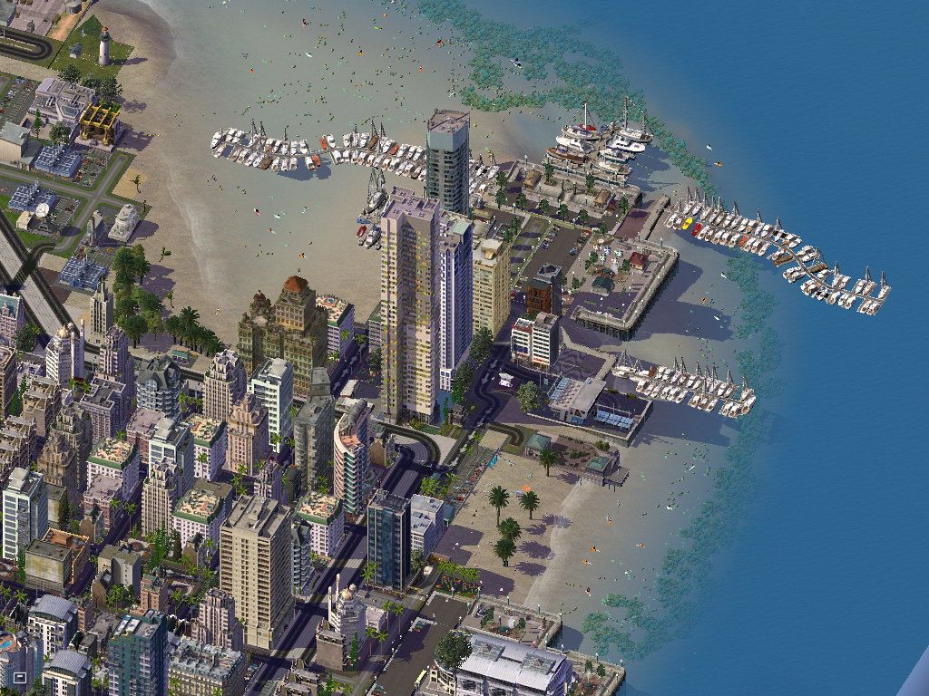


.jpg.bd6d174d70e139332010945c9e70b2e7.jpg)


-
Recently Browsing 0 members
No registered users viewing this page.
-
-
-
City Journal Statistics
-
Total City Journals3,961
-
Total Entries22,822
-
-
New Entries
-
-
Recent Comments
-
 That's a lot of industry! Im curious, where are the commercial zones in the city? I couldn't spot them.
 -

By ilikehotdogsalot · Posted:
Lovely airport! Nice to see Pan Am made a comeback in your city! -

-
-

By Tyberius06 · Posted:
Very cool images and nicely designed airport! Great work! -

-
-
those patterns are really cool! You're a patient planner. congrats!
-
 Can't remember what I voted last time. I think it was a few farms. Anyway I'll go with SAND DUNES today.
 -

By justforfun · Posted:
Ploppable textures would amazing! Meanwhile I also made a small set of S3D fillers. Of course they don't work so well on slopes, haha.
-


