

 Supported
-02-SC4TopoGHC-vs(0)-hs(0)-d5-cMtn0a-n0-k1Z-50-ia(-0.02)-wtr17_92.thumb.jpg.1370c0284d4b6fb53fb21d82eb34e1ce.jpg)
-02-SC4TopoGHC-vs(0)-hs(0)-d5-cMtn0a-n0-k2Z-50-ia(-0.02)-wtr17_92.thumb.jpg.25f17a13b836026f93c6aed4119003c5.jpg)


About This File
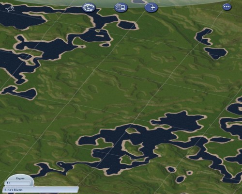
This map represents my first attempt to code in rivers generation to the Offline Planet Map Generator. It got a bit silly with the water going more places than I'd planned for. I really like the look so I'm tossing it out here on the STEX in case other peeps might want to use it. This map also combines my love of rolling hills terrain with pre-flattened terraces for ease of building. The first picture above introduces @Cyclone Boom's SimEarth colors which gives a very realistic satellite view. The second pic is my own version of the in game mini map topographical view. I use this one for my initial major transportation network planning. (Feel free to right click and Save As any of the pics you might want a copy of.) Next you'll see the full rendered region obtained using the Region Census program (both with and without trees). The remaining pics are individual city tile views showing samples of the flattened terraces along with the rolling hills. Those pics are shown using the Columbus Terrain Mod 2 which I modified by setting MaxBeachWidth to 0x9 and MaxBeachAltitude to 9. I feel this defines the coast lines better. Water is by @drunkapple
To use: Put the three files in a folder called Rina's Rivers under your Region folder of SimCity 4 in your Documents. Then simply render in game with Shift+Control+Alt+r from that region screen like any other grayscale import.
Note: Some Terrain Mods have altered the original Maxis settings for the total height, sea level, and import scale factor. If your render does not look like the above pictures, this will be why.
-
 18
18

