

 Supported


About This File
DE:
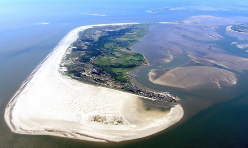
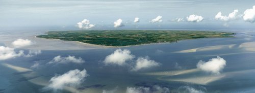
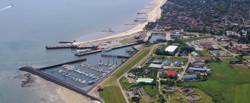
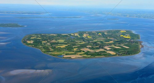
Dies ist eine Karte der Nordfriesischen Inseln ohne Sylt, Größe 33x33km, also eine Bigmap. SimCity kennt keine Gezeiten, daher gibt es auch keine Deiche, die müssen bei Bedarf nachträglich erzeugt werden. Obgleich einige Inseln durch einen schmalen Pfad verbunden sind, müssten diese ebenfalls nachträglich straßentauglich gemacht werden. Die Herausforderung dieser Map besteht demnach darin, die Inseln durch Fährverbindungen wirtschaftlich effizient zu verbinden. Die Region ist knapp besiedelt, die wichtigsten Wirtschaftszweige sind Tourismus und Landwirtschaft, es ist somit die zweite Herausforderung für den motivierten Spieler, etwas mehr rauszuholen.
Dabei wünsche ich viel Spass. In eigener Sache betreibe ich eine kleine aber internationale facebook-Gruppe für Simulationsspiele aller Art, insbesondere natürlich SimCity 4, die SimCity4 AG, schau doch mal vorbei, oder mach gleich mit.
Installation: SC4-Mapper ist ausdrücklich NICHT zu empfehlen, sondern:
1. SimCity 4 starten, neue Region erstellen, Wasser auswählen und benennen, zB: Nordfriesische Inseln
2. SimCity 4 beenden, den SimCity-Regionsordner öffnen (bei mir: C:\Users\Nick Bauer\Documents\SimCity 4\Regions), und mit der geladenen config.bmp die vorhandene ersetzen
3. SimCity 4 erneut starten, neue Region auswählen, Strg+Alt+Umschalten+R zusammen drücken, in kleinen Fenster oben links die geladene "nordfriesische.inseln.2049.bmp" suchen (bei mir meist im Download-Ordner: C:\Users\Nick Bauer\Downloads)
4. Hat alles geklappt wird die Region erzeugt, das dauert etwa 10-15 Minuten, vielleicht mit einem Kaffee o.ä. überbrücken
5. Sobald die neue Region angezeigt wird kann es losgehen
6. Bei Problemen wende dich an die o.g. Gruppe oder an mich persönlich: Nick Bauer
Ich freue mich über Kommentare und höchstmögliche Bewertungen.
EN:
This is a map of the North Frisian islands without Sylt, size 33x33km, so it's a bigmap. SimCity does not know tides, so there are no dikes, which have to be produced afterwards. Although some islands are connected by a narrow path, they would also have to be enlarged in the game. The challenge of this map is therefore to connect the islands economically efficiently by means of ferry connections. The region is sparsely populated, the main economic sectors are tourism and agriculture, making it the second challenge for the motivated player to get a little more.
I wish you lots of fun. On my own behalf, I run a small but international facebook group for simulation games of all kinds, especially SimCity 4, the SimCity4 AG, have a look, or join in.
Installation: SC4-Mapper is NOT recommended, but:
1. Start SimCity 4, create and name a new region, eg North Frisian Islands, choose water
2. Exit SimCity 4, open the SimCity region folder (for me: C:\Users\Nickbauer\Documents\SimCity 4\Regions), and replace the existing config.bmp with the loaded one
3. Restart SimCity 4, select the new region, press Ctrl + Alt + Shift + R, find the "nordfriesische.inseln.2049.bmp" in the small window at the top left: (for me: C:\Users\Nick Bauer\Downloads)
4. If everything has worked out the region generates, which takes about 10-15 minutes, maybe with a cup of coffee
5. Once the new region is displayed, it can start
6. If you have any problems, please contact the group above or myself: Nick Bauer
Please feel free to commend and rate high.

What's New 1.2.0
Released
- new greyscale-bmp (1.2.0)
- coastal lines optimized (1.1.5)
- flooding surfaces built-in (1.1.4)
- paths between some islands and mainland built-in (1.1.3)
- beach areas created (not visuable in screenshots/ 1.1.2)
- island heights adjusted (1.1.1)
-
 5
5






Recommended Comments
There are no comments to display.
Sign In or register to comment...
To comment in reply, you must be a community member
Sign In
Already have an account? Sign in here.
Sign In NowCreate an Account
Sign up to join our friendly community. It's easy!
Register a New Account