Supported


About This File
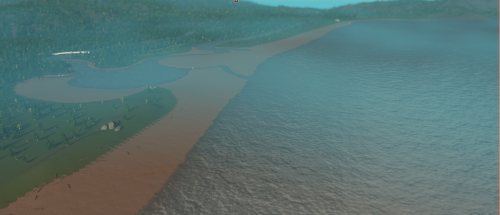
Seaside and Gearhart Oregon taken from terrain party GPS map(18km, 1:1 scale). Scenic ocean side city right next to Lewis and Clark's path to the Pacific(Lewis and Clark River). Abundant in all in game resources. Ore and oil in the mountains, with fertile farmland near the river flood planes.
Highway 101 and Lewis and Clark Road placed by hand based off google maps. Hand modeled beach sloped correctly(no steep cliff drops), abundant in driftwood and scenic rocks. Lewis and Clark River, Little S Fork Lewis and Clark River, and Necanicum River modeled with water props. Water props placed so that ocean currents do not flow into inland river(you can dump waste into the ocean without it coming back into the rivers). The Lewis and Clark River drains out of map(north end) and can be used for waste dumping. Negative current water props placed near the rocky, beach side mountain to pull waste currents from the beach(pulls to the southwest corner of map).
IRL non-existent railroad placed from north to south end of map(follows Lewis and Clark road for northern part). Railway connections on extreme north and east end of map(accessible with 81 tiles). Highway connection on extreme east near the railways connection(accessible with 81 tiles).
What's New 1.0.1 View Changelog
Released
Removed trees in the farm areas. Before they were just seen as forest land by the game.
-
 1
1