

 Supported

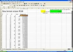

About This File
This tool is for the SCTF and SC4Mapper.
It derives colour scales for use in GIS programs like Global Mapper and has been set up for it . For other programs you will need to find the file structure for custom colour scales.
This is for use by mappers and is available for anyone who wishes to test out the new feature of SCTF.
For technical data refer to the technical data sheet and readme files available in the mapping forum and Support is in the NHP support thread.
This package contains
- The MS Excel spreadsheet
- The readme file
- The technical data sheet
- 2 x 1025 square images png format
- Mount Kaputar DEMO
- Everest DEMO
Installation
To install extract in a folder that is easy to navigate to/from
Instructions
1. To generate a colour scale change your value in the Orange box This represents the absolute lowest elevation. In SC4 and SCTF.
2. copy and paste the values to the spreadsheet titled Values only in Excel right click and select paste values only. You only want the elevation values . there is no need for copy pasting the RGB values as they are correct.
3. Save Values only as a text delimited by spaces. For other programs that use DEM/terrain files another file type may be more appropriate. It will be a printable file if you use MS Excel.
4. Now you need use to Word Pad or any other text editor to open and save the file as a clr file change the file to: Name.clr
5. Open Global Mapper 8 or higher and import colour scale, select initalize from clr file and navigate to your file and click ok. You are then able to do screen captures or export as Geotiff depending on your version of Global Mapper.
6. Either export if you have the Registered version or capture the screens of the terrain you want.
-
 1
1






Recommended Comments
Sign In or register to comment...
To comment in reply, you must be a community member
Sign In
Already have an account? Sign in here.
Sign In NowCreate an Account
Sign up to join our friendly community. It's easy!
Register a New Account