

 Supported
About This File
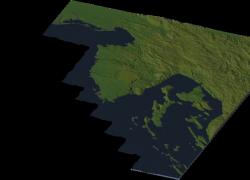
Newest map from Balkanika edition: Istra peninsula, westernmost part of Croatia together with Gulf of Trieste, northernmost part of the Adriatic sea.
Istra ( or Istria in Italian ) is the biggest peninsula in the Adriatic sea.
It is shared by Italy, Slovenia and Croatia, and the third one hold the biggest part of it. It is between Gulf of Trieste and Gulf of Kvarner. At the north you can see easternmost parts of the Po lowlands, Tieste metropolitan area, and southwestern parts of Slovenia. The whole east is continental Croatia between Rijeka and Karlovac. There are also islands like Krk, Cres, Goli otok and many more.
This region is four times smaller than in reality ( altitudes have also been lowered four times ).
***NOTE***: Due to refusing of a picture making program to show me the picture of the whole region without it being in a shape of a rectangle, I had to add those tiles which aren't suppose to be in config.bmp. I erased them later, and the picture had to be blackened. I am sorry for not doing it in professional way, but you can see everything what you need to see.
Enjoy!
Greetings from Serbia!

