

 Supported

About This File
There are two kinds of people that participate in creating maps for the maproom. Those who play around at random to form a map (that may or may not work), and those who meticulously plan and execute every detail of land and sea.
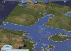
This was an experiment to combine both sides: I wanted to create a map using multiple Landscape Designer screenshots (random) fuzed together (planned) to form a region.
Using Gimp, this region uses sections from over a dozen screenshots. While image masks, selective cutting, blurs and smudges were used, not one pen stroke or brush stroke were employed to form the composite image.
The greatest challenge was changing the colours to proper greyscale values, as the shorelines (for example) if simply desaturated (colour removed) would produce alpine height values. [The water mountain spikes in this region are not a result of this problem, they are "artifacts" that occured when the water was desaturated.]
Overall, the resulting map gives excellent geographic variety and realism; providing interest without interfering with gameplay. The main drawback is the water is in many places too shallow for proper seaport/ferry development--but at least it would give enough rocky shore scenery to give your sims a good drive.
The unzipped file contains a greyscale jpeg and a config.bmp, requiring no additional files, assuming you have SimCity4. See my first upload, "Heart Isles" if you need more information on how to add a downloaded map to your region files.


