Supported


About This File
G'Day Simtropians,
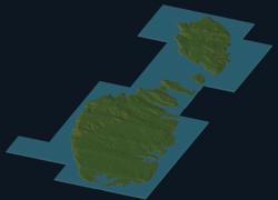
Well there was something wrong with the first version and has been duly blown away. Anyhow Mayorfabz requested this rotated version of the Maltese Archipelago, rotated 45o. The airport and the harbour now are north-south rather than winky-wonky.
See me up CLOSE and personal.
This is a real world map and was produced with dem and satellite data.It measures 20.48km x 45.056km and utilising 16bit mapping technologyit is in .SC4M format. Wouanagaine's mapper or terraformer is requiredfor importation. The map is terrain and scale accurate.
A readme has been included containing some links and instructions and a picture.
I think that's all.
Cheers
Let's hope this one works :wink: