-
Announcement
-

Simtropolis Returns! 05/26/2026
See here for details about our site recovery efforts.
-
Search the Community
Showing results for tags 'austin'.
Found 4 results
-
https://www.theguardian.com/us-news/2016/jul/31/austin-shooting-multiple-victims-reported-in-texas?CMP=Share_AndroidApp_Tweet As of when I'm posting this, there's little information circulating as to what exactly is going on. This article I found is as sufficient as I could find. I'll try to remember and update this thread with new information as it surfaces, but if I don't, if you guys would be so kind as to leave posts down below with new information regarding this, that'd be great. My prayers and condolences to the victims and their families as well as the city of Austin.
-
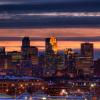
Here is a quick overview of Austin and the many neighborhoods throughout. Here we have the entirety of Central Austin (so far) Downtown Austin is right along the north bank of the Red River (north is the left side of the photo, south is the right). Midtown is directly East of Downtown and surrounds Loring Park, the large green space right along the river. North Austin is across the Loring Memorial Highway from Downtown and encompasses the city of Harrison, Denton, and Orchard Park. North of Orchard park and Denton is the J.M. Harrison International Airport. The Airport is one of the busiest in the United States, serving millions of passengers per year. J.M. Intl was originally focused on domestic flights, connecting to airports such as Atlanta, Denver, Chicago, Dallas, Minneapolis, and Los Angeles. But after a recent expansion in the 80's, including an addition of two new terminals and 3 new runways. AJM is now servicing over 2 million international passengers a year. Downtown by helicopter. Austin's main downtown surrounds Phillips Square, an 8 way interchange that connects the city's major avenues. Directly west of Phillips Square is the Federal District which houses several government and other important buildings. These include the Capitol, Austin City Hall, Harrison County Court House, several federal offices, and the Cathedral of St. John. Past the Capitol building is the New Financial District, which is made up of dozens of tall glass offices, all built within the last 20 years. East of Downtown is Midtown which is mostly mid-rise apartments with the occasional office building. Midtown is suprisingly home to Austin's tallest building, the Pinnacle. The Pinnacle is a 842 foot tall primarily financial and banking building with it's main tenants being Goldman Sachs, U.S. Bank, and Wells Fargo. But the Pinnacle's title may fall within the next few years as many pending projects aim to take it away. Here we have North Austin, mostly low density residential and commercial, there are a few commercial hubs that rise above the surrounding homes. This picture includes the cities of Denton (bottom), Orchard Square (Top Left) and Harrison (to the right of Orchard Square) View from the beginning of the east suburbs, The Pinnacle dominates the skyline with the rest of downtown sitting behind it. To the right of the picture, the newly constructed Harrison International Finance Center can be seen with North Austin in the background.
- 2 Comments
-
- 4
-

-
- austin
- cities skylines
- (and 1 more)
-
http://xgames.espn.go.com/events/2014/austin/schedule/ Anyone excited?
-

1774-1845: A history of Austin, California
jephonesewarrior posted a City Journal entry in City of Austin
It's early April 1774. A young explorer named Fernando de Austin, approaches the Pacific Ocean. He decides to make camp there. He builds a nice European-style building, which is today town hall. He notices that the soil here is quite fertile, unlike the rest of Southern California. He decides to bring settlers here, and calls the town Austin. Many years later in 1845, the city became a boomtown, due to the Gold Rush. ___________________________________________________________________________________________________________ Thanks for Reading. There will be more soon. Jephonesewarrior