Supported
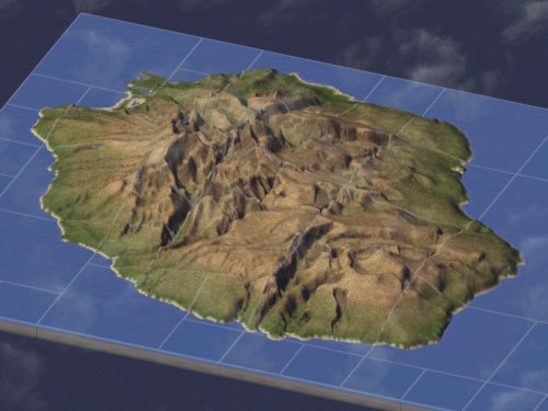

About This File
En : I Know how much precise is a previous file based on satellite datas. Whenever, this version watch many interests . The uncompressed file is plug and play in the Region folder. This region is partitionned to zone correctly main towns. Its concept is to try several potilical actions. It can be as from fondation, as with actual mayors(2014). A pdf file content all this informations. Up to you to do better, or, a little bit more difficult, hire actions!
Future updates would have more precise relief, preloaded dates of fondations, ...
Fr : Je sais ô combien il existe une version précise de l'île basée sur relevé satellite. Cette version présente plusieurs intérêts. Le dossier est plug and play dans les Régions. La région est découpée de manière à représenter les principales communes historiques. Il est possible d'y tenter plusieurs politiques, dès l'origine, ou avec les maires actuels (élection municipales 2014, voir un des fichiers pdf joint), d'y faire mieux ou, plus difficile, pire qu'eux!
Les versions ultérieures pourraient soit être plus précise,soit avoir des villes à date préchargée pour leur création, ...
What's New 1.0 View Changelog
Released
En : Le size of the map has been thinly adjusted. (~2.5x the A version) So, little commons can appear, and the landscape has more details. Plug-and-play version in the region folder should be a 27 MB load.that is why i didn't post it. To Install this version:
- create a region directly from the *.SC4M with the (non-included) "NHP SC4 Mapper (2013)".
- load normally the region with Simcity 4.
- open each part of the 101 tiles to achieve the modeling. You can realize the plains are stairs. Heavy relief is OK
- For each part, smooth the whole landscape with the button in god terra-former mode (2 to 5x).
With 100 + 1 iteration of this operation, your map is ready. Never Use the Adjust the limit : you will irremediably lost details, even after complete regeneration. If you did it, don't save the part of town.
Fr : La taille de la carte a été plus finement ajustée. (~2.5x la version A) De cette manière, les petites communes ont leurs place, et les détails de terrains sont plus nombreux et plus fidèles. La version Plug-and-play à ce niveau de précision ferait 27MO de chargement, raison pour laquelle j'ai préféré ne pas la poster. Pour installer cette version :
- créer la région directement du fichier *.SC4M joint, avec le (non-inclus) "NHP SC4 Mapper (2013)".
- charger normalement la région dans Simcity 4.
- Ouvrir chacune des 101 parcelles pour finaliser la modélisation. Vous réaliserez alors que les plaines font des terrasses comme des marches d'escalier. Les reliefs accentués (falaises, pics, autres pente) n'ont pas besoin de corrections.
- Pour chaque "ville", Adoucir le paysage avec le bouton Adoucir l'ensemble du terrain du terra-former en mode divin (2 à 5 x ).
Après avoir passé en revu les 100 + 1 parcelle, votre carte est prête à jouer. N'utilisez pas "raccorder les limites, même après cette génération complète. Les inégalités inciteraient à perdre de la précision. Si jamais vous faites cette opération par inadvertance, NE SAUVEGARDEZ PAS LA VILLE dans ce cas.
-
 2
2