

 Supported

About This File
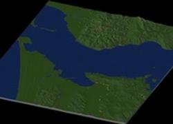
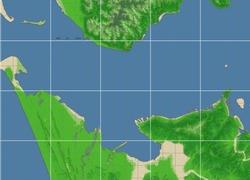
NHP Astoria Oregon By blade2k5
Map Details and Information
The city of Astoria is the county seat of Clatsop County, Oregon, United States. Situated near the mouth of the Columbia River, the city was named after the American investor (and first millionaire) John Jacob Astor. His fur trading company founded Fort Astoria at the site in 1810. Astoria was incorporated by the Oregon Legislative Assembly on October 20, 1876.
Located on the south shore of the Columbia, the city is served by the Port of Astoria with a deep water port. Transportation includes the Astoria Regional Airport with U.S. Route 30 and U.S. Route 101 as the main highways, and the Astoria-Megler Bridge connecting to neighboring Washington across the river. The population was 9,813 at the 2000 census. As of 2007, the state estimate raised it to 10,045 residents.
Map Specifics
Map Type: Real World
Region map size: Map is configured for 30 large city tiles and is 5x6 in size.
config.bmp size: included with zip file
Dependencies: Either SC4 Mapper or SC4 Terraformer for importing.
Maps were created by taking 1/3 Arc USGS DEM elevation data.
Install/Uninstall Instructions: Can be found in the readme provided.
Credits
blade2k5 - Original map creation, scaling, importing. SC4TF modification.
Check out more maps by blade2k5 and NHP
Any comments and feedback welcomed. Thanks for looking and enjoy.
-
 1
1


Recommended Comments
Sign In or register to comment...
To comment in reply, you must be a community member
Sign In
Already have an account? Sign in here.
Sign In NowCreate an Account
Sign up to join our friendly community. It's easy!
Register a New Account