Supported


About This File
G'Day Simtropians,
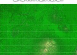
Today I have a map of Mt Ruapehu to show, situated centrally in the North Island of New Zealand. It is a favourite haunt of both skiers and volcanologists as it is not only the highest point of the North Island but also a very active volcano.
Recently Craig-Abcvs asked if I could make a map of Raurimu and the curly wurly railway. Seeing as it was only a little west of Mt Ruapehu I decided to update it and add Raurimu and 2 tiles to the width of the map
This map is accurate in terrain and scale. The elevations are correct and the highest point is Tahurangi at 2797m.
This is a 16 bit map made with dem data and measures 45.056km x 53.248km, it is in .SC4M format.
Yep one needs wouanagaines mapper or terraformer to import this map into one's game.
The rules: the rules are in the readme along with various links to things like mapper and terraformer if one does not have them.
I think that's all
Cheers