

-
Announcement
-

Simtropolis Returns! 05/26/2026
See here for details about our site recovery efforts.
-
Search the Community
Showing results for tags 'southrode'.
Found 9 results
-
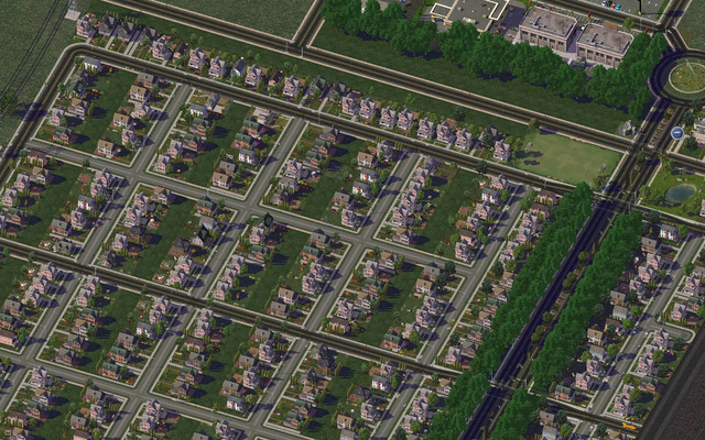
A small update this time, with only two pictures - but they're mosaics! Click for full size :-) 1. New Suburban Area in Southrode First is a picture of the new suburban development in Southrode, next to, but isolated from, the commercial zone. I'm pretty happy with the roads here. I especially like the curves and the cul-de-sacs. 2. Newly Zoned Area in East Edge This second, huge, picture is of the newly built residential and commercial medium-density buildings in East Edge. I definitely want medium density here, but some of the buildings are pretty tall... I might bulldoze those and make the shorter ones historical. I wish there was some sort of no-skyscrapers-for-medium-density policy. Bonus Picture: Diamond Interchange at Night ___________________________ As I've said before, I don't have any particular plan for this region. I'm just drawing roads and zoning as I'm going along. I plan for the medium-density area in East Edge to eventually culminate in high density further down. Again, all tips are hugely appreciated, especially as to what I should do the closer I get to the coastline - I'm have virtually no experience with coastlines. Hope you liked the mosaics, and thanks for tuning in again!
-
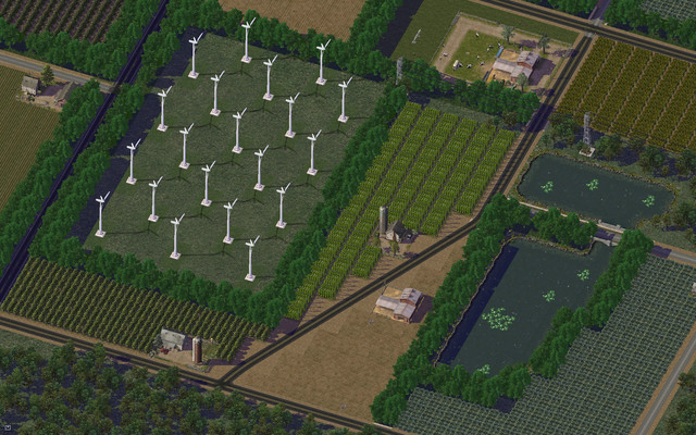
Today, I founded the first city in Ocean's Edge, and called it Southrode. Divided by a four lane rural highway, most of it will consist of farmland, but also some suburbs leaking from the future adjacent city East Edge. Believe it or not, I do care about the names of my cities. Southrode comes from "south" and Old Saxon "rodan," which means "to clear." I got the inspiration from the common Swedish suffix for city names "-ryd." It doesn't make much sense basing the city name on a Saxon word, seeing as how I imagine this fictional region to be located in America, but it's a nice name nonetheless. 1. Rural interchange: This is the folded diamond interchange that brings traffic from and onto the regional freeway. Unfortunately, as you can see on the right, one turning lane piece didn't fit. I might move the interchange one tile down, or simply remove all turning lanes - it's not supposed to be a densely populated area. 2. Farmland, windmills, and a pond In the heart of the Southrode farms stands the small wind farm powering the local area. I made heavy use of the draggable fractional angle roads here - they work like a charm! 3. Irrigation canals: Some discreet irrigation canals. I'm not entirely happy with the way the trees around the canal conflict with the darker forest parks. I might replace those with farmland. 4. Satellite view of the farms: Here you can see the entirity of the farmland, with a huge state fair and small farmer's market in the middle. I intend for the farms to follow the highway, potentially on the other side as well. 4. Leaking suburbs: At the edge of the map, you can see some low-density suburbs terminate. I intend for these to be a continuation of the much greater suburbs of the adjacent city, East Edge. 5. Commerical area At the end of the suburbs, there is a small, isolated commerical area, with the main attraction being the gigantic Target store, which will undoubtedly bring in traffic from the suburbs as well as from the regional freeway. 6. Full view of Southrode ___________________________ So, that was my first ever city journal entry. I'd really appreciate constructive criticism, as well as suggestions on what to put in the empty area above the commercial zone. Thanks for tuning in!
-

-

-
-

-

-
-


