Mascalzone
-
Content Count
341 -
Joined
-
Last Visited
-
Most Liked
2
About Mascalzone
-
Rank
Foot Soldier

Recent Profile Visitors
1,279 Profile Views


-
New CJ entry!
-
Hi There again folks! I'm really happy that the redevelopement work of The Bright City is being appreciated! Unfortunately I also noticed that all of the images attached in the previous chapters published three years ago (but not the first two ones, which is quite strange) are no logner available and I'm sorry because no more direct comparison will be possible with how the city was in 2015. But, and this is the good news, regarding this part of the city I've been able to find some old screenshot saved in my HD, so the comparison there will also be in this chapter even if it will be the last one. For this reason, and also because what has to be shown to you is really much, I dediced to go a bit quick and show you in a single entry what previously was in four (Chapter III, IV, V and VI to be precise). The remastered version differences are really a lot so let's begin, but first of all... @Kingkhufu @wallasey @sunda @VALASatoshi @bobolee @Dead_End @Elenphor @mrsmartman @f3cs Thanks for the likes and comments! Without your support it's not the same! HELLFIRE BAY IN 2015 Hellfire Bay it's the inlet directly facing the the Victoria Harbor Island and that, has such, has a large mercantile traffic within it with numerous cargo ships continously passing through to dock the piers facing the bay (as you've seen in the previous chapter the remastered version of Victoria Harbor also has many piers not facing the bay but the ocean). Before going into details it is worth to take a look at the whole bay as it is now in the morning and, why not, also by evening: HELLFIRE BAY IN 2018 Please let me say that the harbor's loading yards are not empty at all, but by this far there's no way to make the custom props visible! So, it is quite a large bay surrounded by mountains (it is almost the same in the whole city!) that directly faces the estern open sea. There are as many as eight city districts (three of the being islands) that overlooks at it making it the most peculiar by this point of view, but certainly not the largest. Well... then let's see these districts (seven of eight, since one of them - not visible in the pictures above - will be included in another entry) one by one! BRIGHTVALE IN 2015 BRIGHTVALE IN 2018 This is one of the largest districts of Aurora (so much that its notheastern part - on the right in the image above - continue beyond Hellfire Bay) although, by far, not one with the highest population given the low density of its housing, with some exceptions like the area surrounding its living center, with the train station, the town hall and the local high school. The almost peculiar feature of this district is for sure the Victoria Harbor east checkpoint, not on the harbor island itself but located in this district eastern limit and connected to the seaport through a four lanes, one way tunnel. Moving west, we arrive to an important intersection: the largest Brightvale Boulevard on the left brings the traffic directly to the Stonehaven district, while the narrowest Magnolia Avenue leads to the homonymous district. While the first one is served by a bus line and full of parking lots and shops, with also some offices the other one is a narrower quiet street next to the railway. Heavy traffic is banned here. s MAGNOLIA IN 2015 MAGNOLIA IN 2018 In this rather small district is the first important purpose change of the remastered version we encounter: in 2015 it substantially was a large farm the city needed essentially because it was still rather small, but it clashed far too much with what surrounded it. Mostly for this reason this has become a neighborhood that merges perfectly with Brightvale, whose main features are a rather large sports center next to a really exclusive private high school and one the biggest cemetery of the city, together with a train station only used by the local train service that go across Hellfire Bay and, ultimately, a land value even higher than Brightvale due to the large parks nearby that certainly make it a pretty desirable neighborhood as long as you can afford it! STONEHAVEN If you're impressed by the skyline you can see in the last picture... hey that's not downtown! It's just the Hellfire Bay one, the pretty small but busy district of Stonehaven, as in 2015 the neuralgic center of the whole bay: here is its largest train station with intercity trains, a large bus terminal to which all the bay bus lines stops and the connection to the higway (the highways to be precise, since one starts right here) and, most importante of all I guess, the Hellfire Bay General Hospital. Here are large condos, a big interchange parking just next to the station, a ferry terminal with a fast connection to Victoria Harbor and the Literature and Philosophy faculty State University. Its weak point is the lack of commercial areas. LYON HILL Just north of Stonehaven there is a hill ruling the entire bay: this is Lyon Hill, whose name is due precisely to this. It's a very little borough, but pretty exclusive, since it is in a very close position to the main transit hub of the bay, without suffering any traffic congestion since the road leading to the neighborhood is used only by its residents. The distinctive feature of this neighborhood is certainly the great basilica located on the top of the hill, very sought after for weddings and also for the spectacular belvedere right in front of its facade, from which you can get a breaktaking view of the entire bay. FREEMONT Time to go deeper into the bay, coming to a very particular district in terms of shape: Freemont is indeed a very long high density strip that follows the bay profile. It definitely is the commercially best served area of the bay even if, let's say it openly, if you want to have serious shopping you have to take the highway or train and move to other areas of the city! Just about the highway: it's not possible not to speak of the largest intersection of the whole city, known as the "Hellfire Loop" that connects two of the main arteries of the city highways system. IRVINE Where Freemont ends, Hellfire Bay ends. But before moving to this area we have to go west and arrive to Irvine, another mostly low density, high value residential district without particular attractions if not the tranquillity of living here. The most noticeable things probably are that its southernmost part is de facto inside a gorge, its uncommon sunken train station and the small but quite renowned track & field stadium mostly used by juniores. And here we exactly are where we were at the end of the previous chapter, at the junction leading to the Aurora Harbor Bridge located south of Freemont district, and this journal entry (pretty long!) is going to end, even because it is getting dark... HELLFIRE ISLAND But isn't something missing? Yes, and it's rather obvious not to say prominent! Also because it is what gives energy to this whole area and beyond: the Hellfire Island power station, located on the small island connected via bridges to Freemont and Stonehaven. But if you're planning to take this shortcut to avoid the traffic on the highway you'll be very disappointed: access to this island is restricted to authorized personnel only, and anyone must be equipped with an identification card and an authorized license plate to pass unharmed the two militarized checkpoints located at both edges of the island. In essence, here is a big part of what makes the city working and that's why security measures are so high. There are rumors that there are snipers placed at strategic points and that every now and then, to stay trained, they shoot the seagulls! And that's all, for now! But before leaving... I'm pretty sure you might be interested in having a map of this area! So.. here it is at the highest possible resolution I've been able to make it! There's no legend but seems to me it is quite easy to understand (let me know if you think it's not!), let me just say that the black and white lines are the train lines! As usual, let me finish with a last image that previews the next entry! Keep followin' and you'll be surprised!
-
Hey there! new CJ entry after three years!
-

Chapter XVII: Victoria Harbor Remastered
Mascalzone posted a City Journal entry in Aurora, The Bright City
I'M BACK! Hi there folks! I'm quite sure many of you do not remember this CJ, whose last entry was dated November 2015, but as you probably guessed reading the title it's completely not new! My work with the marvellous Cities: Skylines has been very intense three years ago and I published many chapters showing the city of Aurora in 2015 on Simtropolis.com, being feautured 13 weeks in a row in the Ben's Top Ten and, since I've resumed it from about one month, I want to share it again and again! I do not know if it's usual here (maybe sure it is!) but when I decided to get back play Cities: Skylines, with many new DLCs released by Paradox and a new and really more powerful PC, I made up in my mind to complete the job I interrupted for a thousand reasons, no time being the first... After downloading the game again and buying several DLCs I reloaded my saves but... woohoo!! About nothing worked properly and OMG there were so many new mods out there to try and make use of to get to the usual, almost unattainable achievement: realism! Realism at all costs! But, to be clear: Aurora is not at all a real city, it's just my city. Based on the original real challenging New Caledonia map by MrMiyagi that I think is no more available, since it has been completely renovated too (it is only downloadable in its 2018, flattened, version), this map asks you to build a city that develops on several different coves connected to a central mountain massif. Reminds, a bit, Hong Kong. I fell in love with it in 2015 it and I still think it's really amazing to try to build a realistic metropolis in such an enviroment! Since a picture is worth a thousand words, here is an aerial view of the map taken from my very first CJ entry dated August 2015: AURORA REMASTERED: VICTORIA HARBOR Believe me, it's almost shoking to me see this map empty! As you can read in that old entry linked above the masterplan was great and I am proud to say that it has been almost completed and not only that: I went ahead starting the phase II that I will show you as soon as this series of entries, dedicated to the renovation of everything was already shown (and you can see all the previous entries here), is completed. I know you got tired of reading, but let me say one last thing before publishing pictures as if there were no tomorrow: the conformation of the city, its neighborhoods, the road network remained exacty (almost!) the same, that's why I'm talking about a remastered version of the city instead of a remade one. What has changed are definitely the buildings and the level of detail allowed by all the great additions released on the steam workshop in these three years. So... let' start! I will try to follow the same order of the 2015 entries first introducing the location through an old photo (remember you can check them all through the above link if you want!). VICTORIA HARBOR 2015 Victoria Harbor already was one of my favourite parts of the city: a seaport completely located on an island it's something uncommon... VICTORIA HARBOR 2018 But look at it now! The same location looks absolutely different: the unrealistic Ibiza-like southside beach has gone replaced by piers, that allow ships to dock on both sides of the island. The seaport now also hosts a ferry terminal, with two lines serving the surrounding Hellfire Bay. Everything it's still in its place: the cargo train terminals, the passengers train station adjacent to the Port Authority Hedquarters tower and all the factories of the seaport industry, the main Control Tower and the gargantuan Logistics Center that serves the whole region. Also the west security checkpoint is still in its place, as well as the east one that we'll be shown later. On the southwest side of the island there also is a very large composting center near to a large water treatment plant, not forgetting the prominent lighthouse and the ferry stop. THE 2015 VICTORIA HARBOR BRIDGE As I told you Victoria Harbor is on an island, that obviously needs to be connected to the mainland. On the west side it is trough a large bridge, that in the old version wasn't much landmarky... THE 2018 VICTORIA HARBOR BRIDGE Well... this is the new one! Just slightly better i guess. And no, believe me it's not the most impressive in the city, but for sure it's the most used by lorries! And before leaving the harbor and closing this first entry of my coming back, a pair of aerial screenshots showing the whole harbor island. Before leaving, just a teaser of what will come next! Feel free to leave comments and... keep followin' and you'll be surprised! -
Awesome, great work!
-
Cities: Skylines patch 1.2.2-f2 released, limits raised!
Mascalzone commented on Thin White Duke's article in News
I have a $ 800 PC (monitor included) bought 2 years ago and C:S runs properly too, 30-40 stable FPS with 1920x1020 and about 600+ mods and assets. A quad core CPU, 8 GB RAM an SSD and a good GPU (I have a very normal and quite outdated nVidia 670 GTX) is what you need to play this game. And damn if it's worth playing! -
Your CJ is lovely, I really like the ongoing growth feature. A question: how the hell you manage to place props on tarmac (i.e. over other objects)?
-
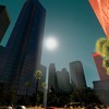
Time for the second entry of the Aurora CJ focused on downtown. I do not know yet how long this series will be, but you can expect at least two more episodes. But the most important thing though is that you seem to like 'em! FEEDBACK CORNER WALKING IN DOWNTOWN #2: TRAVELODGE HOTEL - JOLIET SQUARE Well, after the previous walk and a night of sleep this is the view from the Travelodge Hotel (featured in the Red Light District entry) North Tower: inviting, isn't it? After a filling breakfast in one of the numerous Oldshore district cafes it's time to take another walk to downtown! The city administration has placed many information boards which helps tourists and residents not to get lost, with public transport routes, nearby points of interest, parkings and much more. And just around the right corner you realize tha the primary destination is not far at all! After less than a hundred meters... here you are! Looking left you can see something familiar... it is worth to take a closer look! It's the famous the famous Aurora sign that can be seen in many postcards! Time to cross the street and proceed to downtown! The scrapers prominence here is quite sickening! As if to underline it, here there's even an outdoor cafe! It really is very busy! Just a block west there is another very popular square: the Casey Plaza! Here are the statues of a famous Spanish sculptor... Time for a nose-up again! It's damn hot today! And we're still early in the morning! The scrapers density here is quite impressive... Holding the nose up often it's easy to get lost... this road does not seem very popular with tourists... Luckily there's another infromation board few meters ahead! Well, Joliet Square is just past this pedestrian way! Here we are, the destination of our morning walk! Oh yeah the Aurora Skydome! Want to get up there! Here is also the renowned Victory Column! Gosh! The queue for the Skydome tickets is very long! Why I did miss to book online? Got the ticket! Time to take the superfast elevator to the top! What an amazing sight! If you suffer dizziness do not do this! It's worth the price! Almost forgot there's also the beatiful Opera House right here! Let's move to the eastern part of the square, there's much more to see! This is the hockey stadium Emile Arena, he home of Aurora Thunders! In front of it there is a really strange sculpture that look like a lightning rod. Maybe it wants to resemble a thunder! There's also another wonderful monumental column. This one is dedicated to the XIX century caledonian revolution. A metro station, it's time to take advantage of it! Still have to visit all the southeastern part of downtown, it will take some time! Keep followin' and you'll be surprised!
-
The Bright City
-
-
Chapter XVI: Walking in Downtown #2
Mascalzone posted a City Journal entry in Aurora, The Bright City
Time for the second entry of the Aurora CJ focused on downtown. I do not know yet how long this series will be, but you can expect at least two more episodes. But the most important thing though is that you seem to like 'em! FEEDBACK CORNER WALKING IN DOWNTOWN #2: TRAVELODGE HOTEL - JOLIET SQUARE Well, after the previous walk and a night of sleep this is the view from the Travelodge Hotel (featured in the Red Light District entry) North Tower: inviting, isn't it? After a filling breakfast in one of the numerous Oldshore district cafes it's time to take another walk to downtown! The city administration has placed many information boards which helps tourists and residents not to get lost, with public transport routes, nearby points of interest, parkings and much more. And just around the right corner you realize tha the primary destination is not far at all! After less than a hundred meters... here you are! Looking left you can see something familiar... it is worth to take a closer look! It's the famous the famous Aurora sign that can be seen in many postcards! Time to cross the street and proceed to downtown! The scrapers prominence here is quite sickening! As if to underline it, here there's even an outdoor cafe! It really is very busy! Just a block west there is another very popular square: the Casey Plaza! Here are the statues of a famous Spanish sculptor... Time for a nose-up again! It's damn hot today! And we're still early in the morning! The scrapers density here is quite impressive... Holding the nose up often it's easy to get lost... this road does not seem very popular with tourists... Luckily there's another infromation board few meters ahead! Well, Joliet Square is just past this pedestrian way! Here we are, the destination of our morning walk! Oh yeah the Aurora Skydome! Want to get up there! Here is also the renowned Victory Column! Gosh! The queue for the Skydome tickets is very long! Why I did miss to book online? Got the ticket! Time to take the superfast elevator to the top! What an amazing sight! If you suffer dizziness do not do this! It's worth the price! Almost forgot there's also the beatiful Opera House right here! Let's move to the eastern part of the square, there's much more to see! This is the hockey stadium Emile Arena, he home of Aurora Thunders! In front of it there is a really strange sculpture that look like a lightning rod. Maybe it wants to resemble a thunder! There's also another wonderful monumental column. This one is dedicated to the XIX century caledonian revolution. A metro station, it's time to take advantage of it! Still have to visit all the southeastern part of downtown, it will take some time! Keep followin' and you'll be surprised! -
Welcome back, this is the first of what will be a series of chapter dedicated to Downtown Aurora, with images taken at street level to show what you see walking in the city center. FEEDBACK CORNER WALKING IN DOWNTOWN #1: CENTRAL STATION - APPLE STOREWith the last entry we left at the Central Station exit facing downtown, and now it's time to start a sightseeing tour to visit it as tourists. Let's start with the idea that, arriving at the station in the evening, before heading to the hotel you want a ride driven by passion for scrapers and the emotion of visiting a new city! What you come into going out of the Central Station is Union Plaza, the meeting point of four of the major artieries of the city center and the Downtown starting point. The square is characterized by a small park with a monument to peace in its center, nicknamed "The Hug" from the residents. Crossing the road then you reach the beginning of Madison Avenue. As you can see we're still in front of the Central Station.And then you cannot stop looking up!Turning the eyes south you have the glance of Madison Avenue and it's time to enter Downtown!After few steps, arrived at the first corner we turn left into Hearst street.A hundred meters further a magnificent view opens on many Art Deco scrapers: Andrews Square!This square is very famous for the ice rink open all year!And then it's time to look up again! The buildings overlooking this square are historical and considered the most beautiful in the entire city.Just next to the ice rink there is a small grill kiosk very popular among tourists.Although sandwiches here are not cheap at all it's time for a brief stop!In the south part of the square there is a small plaza with tress and benches very frequented by lovers.What a beast! This is the Caledonian Oil Company Building, also known as the COC! At this point the eyes begins to be attracted by huge billboards...And just around the corner you find that there are still more!Going by some tens of meters on the left there is another square where there is the monument that celebrates the city's founder.One of these billboard looks familiar There appears something unexpected: a park that seems endless!Viewing it seems it will take a whole day to visit! Where to go now? East or West?The hotel is just in front of the bay so let's go west!Wwwhat? A huge phone?Yes it is!Have to go to the hotel now, soon will be dinner time. Taaaaxi!Keep followin' and you'll be surprised!
-
Chapter XV: Wallking in Downtown #1
Mascalzone posted a City Journal entry in Aurora, The Bright City
Welcome back, this is the first of what will be a series of chapter dedicated to Downtown Aurora, with images taken at street level to show what you see walking in the city center. FEEDBACK CORNER WALKING IN DOWNTOWN #1: CENTRAL STATION - APPLE STOREWith the last entry we left at the Central Station exit facing downtown, and now it's time to start a sightseeing tour to visit it as tourists. Let's start with the idea that, arriving at the station in the evening, before heading to the hotel you want a ride driven by passion for scrapers and the emotion of visiting a new city!What you come into going out of the Central Station is Union Plaza, the meeting point of four of the major artieries of the city center and the Downtown starting point. The square is characterized by a small park with a monument to peace in its center, nicknamed "The Hug" from the residents. Crossing the road then you reach the beginning of Madison Avenue. As you can see we're still in front of the Central Station.And then you cannot stop looking up!Turning the eyes south you have the glance of Madison Avenue and it's time to enter Downtown!After few steps, arrived at the first corner we turn left into Hearst street.A hundred meters further a magnificent view opens on many Art Deco scrapers: Andrews Square!This square is very famous for the ice rink open all year!And then it's time to look up again! The buildings overlooking this square are historical and considered the most beautiful in the entire city.Just next to the ice rink there is a small grill kiosk very popular among tourists.Although sandwiches here are not cheap at all it's time for a brief stop!In the south part of the square there is a small plaza with tress and benches very frequented by lovers.What a beast! This is the Caledonian Oil Company Building, also known as the COC! At this point the eyes begins to be attracted by huge billboards...And just around the corner you find that there are still more!Going by some tens of meters on the left there is another square where there is the monument that celebrates the city's founder.One of these billboard looks familiar There appears something unexpected: a park that seems endless!Viewing it seems it will take a whole day to visit! Where to go now? East or West?The hotel is just in front of the bay so let's go west!Wwwhat? A huge phone?Yes it is!Have to go to the hotel now, soon will be dinner time. Taaaaxi!Keep followin' and you'll be surprised! -
Hello fellows, here is a new entry for the Bright City CJ! I resume from where we left with the last one but, as always, let'sstart with your comments. FEEDBACK CORNER HAWTHORNE JUNCTION The last element shown you in the previous entry was the Hawthorne junction, and to share the exact same spot I show you it again this time looking south, ie directly towards the Aurora Central Station and facing downtown. Immediately downstream to this ovrepass system, with four main tracks that directs to the west, the east and two to the north and that together constitute the main railway junction of the entire city with that of Stonehaven, there is an equally important for the highway known among residents as "The Octopus" which is the first of the three intersections that rides through the city center. AURORA CENTRAL Thinking I've illustrated you this complex in details enough, so let's proceed to the next stop: the central station! It is a structure built in art deco style, with ten tracks covered on five arches that can withstand a flow of over forty thousands passengers per day both through metropolitan and regional lines. But what matters most is the fact that Aurora Central is at the heart of a transit system that includes: a bus lines terminal almost great as the railway station (I'm using it to just one-third of its capacity right now) supported by a depot in the immediate vicinity. Furthermore, just in front of the station exit there is a large metro station that is the connexion point between the two underground lines that links all the Maya Bay neighborhoods. Last but not least is the large taxi rank. Essentially, from here, at the cost of a ticket people can reach any spot in the city except for some heights, like the Echelon Peak you well know already. The last key piece of the hub is the multistory parking capable of holding more than a thousand vehicles, widely used by locals and tourists to leave their cars and go for the public transport. But perhaps the most important thing is the glance that anyone has just exiting the station, and in this it can be said that the City of Aurora offers a rather succulent spectacle. The financial district scrapers are just a step away, and the impression of being small before such magnificence is quite palpable! The last picture of this entry it's for the New Caledonia Regional Council building, located right on the northwest of Aurora Central. Although not among the highest it is certainly one of the most impressive and important of the city skyscrapers. The building you see on the right the one open to the public as it houses the Regional Congress and the offices of the regional advisers. And it's everything for this episode: I advise you not to miss the next ones as the guide will go through the streets of downtown, and I assure you that there will be dizziness! Uoops a bonus pic Keep followin' and you'll be surprised!
-