


Jump to content

Kansas City - Missouri  1.0

   (9 Reviews)
Sign In to follow this  

2 Screenshots

About This File

Hi mappers, here is my modest contribution to the community :


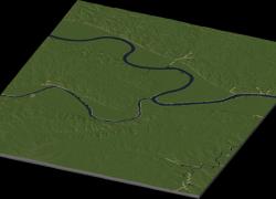
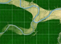
Kansas City - Missouri (File #53)


Kansas City, Missouri (informally abbreviated KC) is the largest city in the US state of Missouri and is the anchor city of the Kansas City Metropolitan Area, the second largest metropolitan area in Missouri. It encompasses 316 square miles (820 km2) in parts of Jackson, Clay, Cass, and Platte counties. It is one of two county seats of Jackson County, the other being Independence, which is to the city's east. As of 2010, the population census was 459,787 with a metro area of 2.1 million (source : Wikipedia).


Map size : 5 x 6 big tiles (20,480 x 24,576 km)

Coordinates : 39°06'35"N 94°35'19"W


Generated from 1/9 Arc DEM

Edited with 3DEM, Gimp, Photo Line and SC4 Terraformer.

Accurate in dimensions and elevations.

16-bit hand quality made


Map designed for SimCity 4 Deluxe and Wouanagaine's SC4Terraformer or SC4Mapper.


Credits :

- Drunkapple's advices and calculation formulas

- Wouanagaine's SC4Mapper and SC4Terraformer

- Simtropolis for hosting this file

- Heblem's terrain mods for rendering the map


Please feel free to discuss and request !


Check out my forum page !


Cheers,


Izi44


User Feedback

Recommended Comments

It's funny how the highways and rails appear to have gotten embedded in the geological image. Very cool for accurate re-creations. Nice work! Compels me to start my KC region all over again...

Share this comment


Link to comment
Share on other sites
[quote name='estates to the real' timestamp='1342545760']
It's funny how the highways and rails appear to have gotten embedded in the geological image. Very cool for accurate re-creations. Nice work! Compels me to start my KC region all over again...
[/quote]

That happened because they are on embankments through the flood plain, all the highways through the low areas are either on embankments or elevated so that when it floods you can still get around unless it's like it was in 1993. There are also levees showing up, and a few other things that are elevated to prevent flooding.

It's really cool to see my hometown, it's would be interesting to recreate the city due to the face that the CBD is positioned on the side of the bluffs and is really quite hilly despite all the flat land around it.

Share this comment


Link to comment
Share on other sites

Sign In or register to comment...

To comment in reply, you must be a community member

Sign In  

Already have an account? Sign in here.

Sign In Now

Create an Account  

Sign up to join our friendly community. It's easy!  

Register a New Account

  • Recently Browsing   0 members

    No registered users viewing this page.

×

Thank You for the Continued Support!

Simtropolis depends on donations to fund site maintenance costs.
Without your support, we just would not be in our 24th year online!  You really help make this a great community. *:thumb:

But we still need your support to stay online. If you're able to, please consider a donation to help us stay up and running. This helps sustain a platform where we can share our community creations for years to come.

Make a Donation, Get a Gift!

Expand your city with the best from the Simtropolis Exchange.
Make a Donation and get one or all three discs today!

STEX Collections

By way of a "Thank You" gift, we'd like to send you our STEX Collector's DVD. It's some of the best buildings, lots, maps and mods collected for you over the years. Check out the STEX Collections for more info.

Each donation helps keep Simtropolis online, open and free!

Thank you for reading and enjoy the site!

More About STEX Collections