

 Supported

About This File
Hi mappers, here is my modest contribution to the community :
Map requested by Breki, thanks gentleman !
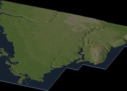
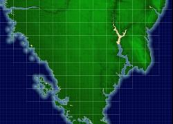
Pula - Croatia (File #25)
Pula is the largest city in Istria County, Croatia, situated at the southern tip of the Istria peninsula, with a population of 62,080 (2006). Like the rest of the region, it is known for its mild climate, smooth sea, and unspoiled nature. The city has a long tradition of winemaking, fishing, shipbuilding, and tourism. Pula has also been Istria's administrative center since ancient Roman times (source : Wikipedia).
Map size : 13 x 12 big tiles (53.248 x 49.152 km)
Coordinates : 44°52'N 13°51'E
Generated from 3 Arc DEM
Edited with 3DEM, Gimp, Photo Line and SC4 Terraformer.
Accurate in dimensions and elevations.
16-bit hand quality made
Map designed for SimCity 4 Deluxe and Wouanagaine's SC4Terraformer or SC4Mapper.
Credits :
- Drunkapple's advices and calculation formulas
- Wouanagaine's SC4Mapper and SC4Terraformer
- Simtropolis for hosting this file
- Heblem's terrain mods for rendering the map
Please feel free to discuss and request !
Check out my forum page !
Cheers,
Izi44


