

 Supported


About This File
Dear SC4 fans, here is my modest contribution to the community :
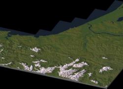
THE BASQUE COUNTRY, from Pasaia (Spain) to Hossegord (France)(File #8 )
The Basque Country (Basque: Euskal Herria) is the name given to the home of the Basque people in the western Pyrenees that spans the border between France and Spain on the Atlantic coast.
It comprises the Autonomous Communities of the Basque Country and Navarre in Spain and the Northern Basque Country in France.
Even though they are not necessarily synonyms, the concept of a single culturally Basque area spanning various regions and countries has been closely associated since its inception with the politics of Basque nationalism. As such, the region is considered home to the Basque people (Basque: Euskaldunak), their language (Basque: Euskara), culture and traditions. Nevertheless the area is neither linguistically nor culturally homogeneous, and the very Basqueness of parts of it, such as southern Navarre, remains contentious (source : Wikipedia).
Location : approx. centered on Biarritz (France)
Map size : 14 x 14 big cities (including empty ones) (56 x 56 km)
Coordinates : 43°28'N 1°33'W
Generated from 3 Arc DEM
Edited with 3DEM, Gimp, Photo Line and SC4 Terraformer.
Accurate in dimensions and elevations.
16-bit hand quality made
Map designed for SimCity 4 Deluxe and Wouanagaine's SC4Terraformer or SC4Mapper.
Credits :
- Drunkapple's advices and calculation formulas
- Wouanagaine's SC4Mapper and SC4Terraformer
- Simtropolis for hosting this file.
Please feel free to discuss about it !
Check out my forum page !
Iz44


