

 Supported


About This File
Map Details and Information
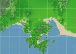
Guaymas is a city and municipality located in the southwest part of the state of Sonora in northwestern Mexico. The city is located 117 km south of the state capital of Hermosillo, and 242 miles from the U.S. border, and is the principal port for the state. The municipality is located in the Sonora Desert and has a hot, dry climate and 117 km of beaches. The municipality’s formal name is Guaymas de Zaragoza and the city’s formal name is the Heróica Ciudad de Guaymas.
The city proper is mostly an industrial port, with nearby San Carlos being the major tourist attraction for its beaches. The city also has a well-attended annual carnival, which has been held since 1888.
San Carlos is a beachfront subdivision within the port city of Guaymas, in the northern state of Sonora in Mexico. It is noted for the exceptional clarity and warmth of the ocean water in its shallow bays. It lies on the body of water known as the Gulf of California or Sea of Cortez. Given the size of the city, with nearly 7,000 inhabitants, there is a remarkable number of RV parks, resorts and stores. There is also a very large and active diving community.
There are also many Americans and Canadians that live in San Carlos during the Winter as the Summer months are very hot. There are many opportunities to fish, dive, and relax on the beach.
San Carlos is about a 6 hour drive from the United States along Mexican interstate Highway 15. The trip from the United States requires that foreigners obtain a tourist visa, but they are no longer required to get a car permit if they are traveling by private automobile. This is only required if they travel south of Guaymas. The area where these car permits are obtained is referred to as "El 21" as it is 21 kilometers from the border or at the border itself.
Map Specifics
Map Type: Real World
Region map size: Map is configured for 48 large city tiles and is 8x6 in size.
config.bmp size: included with zip file
Dependencies: Either SC4 Mapper or SC4 Terraformer for importing.
Maps were created by taking 1 arc elevation data.
Install/Uninstall Instructions can be found in the readme provided.
Credits
blade2k5 - Original map creation, scaling, importing. SC4TF modification.
Check out NHPs Map Catalog forum here.
Check out more maps by blade2k5 and NHP
Any comments and feedback welcomed. Thanks for looking and enjoy.


Recommended Comments
Sign In or register to comment...
To comment in reply, you must be a community member
Sign In
Already have an account? Sign in here.
Sign In NowCreate an Account
Sign up to join our friendly community. It's easy!
Register a New Account