

 Supported


About This File
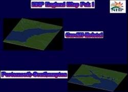
NHP England Map Pak 1 By blade2k5 & papab2000
Map Details and Information
Cardiff-Bristol
Cardiff:
King Edward VII granted Cardiff city status on 28 October 1905, and the city acquired a Roman Catholic Cathedral in 1916. In subsequent years an increasing number of national institutions were located in the city, including the National Museum of Wales, Welsh national war memorial, and the University of Wales registry - although it was denied the National Library of Wales, partly because the library's founder, Sir John Williams, considered Cardiff to have "a non-Welsh population".
After a brief post-war boom, Cardiff docks entered a prolonged decline in the interwar period. By 1936, their trade was less than half its value in 1913, reflecting the slump in demand for Welsh coal. Bomb damage in during the Cardiff Blitz in World War II included the devastation of Llandaff Cathedral, and in the immediate postwar years the city's link with the Bute family came to an end.
The city was proclaimed capital city of Wales on 20 December 1955, by a written reply by the Home Secretary Gwilym Lloyd George. Caernarfon had also vied for this title. Cardiff therefore celebrated two important anniversaries in 2005. The Encyclopedia of Wales notes that the decision to recognise the city as the capital of Wales "had more to do with the fact that it contained marginal Conservative constituencies than any reasoned view of what functions a Welsh capital should have". Although the city hosted the Commonwealth Games in 1958, Cardiff only became a centre of national administration with the establishment of the Welsh Office in 1964, which later prompted the creation of various other public bodies such as the Arts Council of Wales and the Welsh Development Agency, most of which were headquartered in Cardiff.
The East Moors Steelworks closed in 1978 and Cardiff lost population during the 1980s, consistent with a wider pattern of counter urbanisation in Britain. However, it recovered and was one of the few cities (outside London) where population grew during the 1990s. During this period the Cardiff Bay Development Corporation was promoting the redevelopment of south Cardiff; an evaluation of the regeneration of Cardiff Bay published in 2004 concluded that the project had "reinforced the competitive position of Cardiff" and "contributed to a massive improvement in the quality of the built environment", although it had failed "to attract the major inward investors originally anticipated".
In the 1999 devolution referendum, Cardiff voters rejected the establishment of the National Assembly for Wales by 55.4% to 44.2% on a 47% turnout, which Denis Balsom partly ascribed to a general preference in Cardiff and some other parts of Wales for a 'British' rather than exclusively 'Welsh' identity. The relative lack of support for the Assembly locally, and difficulties between the Welsh Office and Cardiff Council in acquiring the original preferred venue, Cardiff City Hall, encouraged other local authorities to bid to house the Assembly. However, the Assembly eventually located at Crickhowell House in Cardiff Bay in 1999; in 2005, a new debating chamber on an adjacent site, designed by Richard Rogers, was opened.
The city was county town of Glamorgan until the council reorganisation in 1974 paired Cardiff and the now Vale of Glamorgan together as the new county of South Glamorgan. Further local government restructuring in 1996 resulted in Cardiff city's district council becoming a unitary authority, the City and County of Cardiff, with the addition of Creigiau and Pentyrch.
On 1 March 2004, Cardiff was granted Fairtrade City status.
Bristol:
With an approximate population of 410,950, and urban area of 550,200, it is England's sixth, and the United Kingdom's ninth most populous city, one of England's core cities and the most populous city in South West England. It received a royal charter in 1155 and was granted county status in 1373. For half a millennium it was the second or third largest English city, until the rapid rise of Liverpool, Birmingham and Manchester in the Industrial Revolution during the latter part of the 18th century. It borders the counties of Somerset and Gloucestershire, lying between the cities of Bath, Gloucester and Newport. The city is built around the River Avon and it has a short coastline on the estuary of the River Severn, which flows into the Bristol Channel.
Bristol is the largest centre of culture, employment and education in the region. From its earliest days, its prosperity has been linked to that of the Port of Bristol, the commercial port, which was in the city centre but has now moved to the Severn Estuary at Avonmouth and Portbury, to the western extent of the city boundary. In more recent years the economy has been built on the aerospace industry and the city centre docks have been regenerated as a centre of heritage and culture. There are 34 other populated places on Earth named Bristol, most in the United States, but also in Peru, Canada, Jamaica and Costa Rica, all presumably commemorating the original.
Portsmouth-Southampton
Portsmouth:
Portsmouth is a city located in the county of Hampshire on the south coast of England. Portsmouth is the UK's only island city and is located on Portsea Island.[2] It is commonly nicknamed Pompey. The administrative unit itself forms part of the wider Portsmouth conurbation, with an estimated 442,252 residents within its boundaries,[citation needed] making it the 11th largest urban area in England. At the 2001 census it was the only city in England with a greater population density (4,639/km² (12,015/sq mi)) than London as a whole (4,562/km² (11,816/sq mi)), although many of London's individual boroughs had a much greater density.
A significant naval port for centuries, Portsmouth is home to the world's oldest dry dock still in use and home to many famous ships, including Nelson's flagship HMS Victory. Portsmouth has declined as a naval base in recent years but remains a major dockyard and base for the Royal Navy. There is also a commercial port serving destinations on the continent for freight and passenger traffic.
The Spinnaker Tower is a recent addition to the city's skyline. It can be found in the recently redeveloped area known as Gunwharf Quays.
The Portsmouth Urban Area covers an area with a population well over twice that of the city of Portsmouth itself, and includes Fareham, Portchester, Gosport, Havant (which includes the large suburbs of Leigh Park), Lee-on-the-Solent, Stubbington and Waterlooville.
The suburbs of Portsmouth, and Southampton to the west, arguably form a conurbation stretching from Southampton to Havant on the M27/A27 road along the coast, and north to Clanfield on the A3 road.
Southampton:
Southampton is the largest city in the county of Hampshire, on the south coast of England.
Southampton is a major port and the closest city to the New Forest. It lies at the northern-most point of Southampton Water where it is joined by the River Test and River Itchen, with the River Hamble joining to the south of the urban area.
The local authority is Southampton City Council, which is a unitary authority. The city is part of the ceremonial county of Hampshire.
Significant employers in Southampton include the University of Southampton, the Ford Transit factory and one of the largest commercial ports in Europe.
The city represents the core of the Greater Southampton region, with a population of 228,600. The city's name is sometimes abbreviated in writing to "So'ton" or "Soton", and a resident of Southampton is called a Sotonian.
Southampton is noted for being the home of the RMS Titanic, the Spitfire and more recently a number of the largest cruise ships in the world.
Map Specifics
Map Type: Real World
Region map size: Cardiff-bristol configuration: 7x8 Lrg tiles, Portsmouth-Southampton configuration: 8x9 Lrg tiles.
config.bmp size: included with zip file
Dependencies: Either SC4 Mapper or SC4 Terraformer for importing.
Maps were created by taking '' DEM data and converting the data through a series of processes to a 16bit grayscale png.
Install/Uninstall Instructions
Installing the Map
To install SC4M map file:
1. If you don't already have SC4Mapper, download it here and follow the install instructions.
2. Unzip this file.
3. Run SC4Mapper, click on 'create region'
4. Choose SC4M
5. Browse to the unzipped folder and point the map file .SC4M
6. Click on 'Save Region' and name it, and Quit SC4Mapper
7. Run SC4 and load the new region. The colors of the region in SC4 will be the same colors as SC4Mapper until you enter and save each city tile. But you have the choice to do it as you go and not right away.
SC4Terraformer
1. Create a new region folder in your Plugins\Region
2. Copy my config.bmp into the folder and overwrite the old one. (make changes to config.bmp file now if you want)
3. Open the new region you just created with SC4 Terraformer
4. Click on Import Image in the Global Tools Menu and browse for my SC4M file.
5. When file is imported click File - Save (the region is now saved to SC4
6. The colors of the region in SC4 will be the same colors as SC4TF until you enter and save each city tile. But you have the choice to do it as you go and not right away.
Start opening tiles!
Any comments and feedback welcomed. Thanks for looking and enjoy.
Credits
blade2k5 - Original map creation, scaling, importing. SC4TF modification.
papab2000 - Original map creation, scaling, importing. SC4TF modification.
Check out more maps by blade2k5 and NHP
Feedback and Support


