

 Supported

About This File
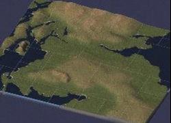
Okay, here's my first upload to the STEX and I am sending you all a map of the 'best small country in the world'. I did this map to use all the UK Bat buildings and lots available on the STEX.
Created using the Google Earth software (http://earth.google.com/) to get the basic coastline and PSP9 to do the greyscaling and hills. These are not accurate, but are representational.
The 'big cities' across the middle can be used for Glasgow and Edinburgh/Lothians, Tayside/Dundee top right with the regions down the Clyde coast each having their own city. Feel free to design your own config.bmp if you want.
Takes about 25-30 minutes to render on my machine (AMD2500, 1.5Gig RAM).
Go easy if you don't like it, this is my first attempt at a map!
'Here's tae us, wha's like us? Damn few and they're aw deid!'
Tweed
-
 1
1


Recommended Comments
Sign In or register to comment...
To comment in reply, you must be a community member
Sign In
Already have an account? Sign in here.
Sign In NowCreate an Account
Sign up to join our friendly community. It's easy!
Register a New Account