

-
Announcement
-

Simtropolis Returns! 05/26/2026
See here for details about our site recovery efforts.
-
Search the Community
Showing results for tags 'mtn north'.
Found 21 results
-

28 - Santa Selena Cliff
philforhockey51 posted a City Journal entry in Region of Mountain North (SC4)
00 - Cover Photo Hi Everyone, Welcome back to our tour of Mountain North. Today we'll be making a stop in Santa Selena Cliff. This is a small tile north of the tiles in the last entry. It's a rather wealthy village with a great love for athletics. The village boasts an extensive playing field complex with a mix of Rugby, Soccer(Football), and Baseball. It also has a running and biking trail. In the northwest there is a cliff that all sorts of climbers enjoy to frequent and some more trails in the woods for hiking and biking. 01 - Road & Trail start 02 03 04 05 06 07 08 09 10 11 12 13 14 15 16 17 18 19 20 - grown 21 22 23 24 25 - the black thing is the back of a vending machine.. damn thing plopped backwards, only fix would be to demolish all the mmp work around it 26 28 This brings us to the end of this entry, hope you enjoyed it. If there are any areas you would like a closer look at please feel free to request, I'll post it in the comments. As always any comments or questions are welcome. Thanks for taking a look ~Phil -
26 - Canada Corner & Blue Hill
philforhockey51 posted a City Journal entry in Region of Mountain North (SC4)
Welcome everyone to Canada Corner and Blue Hill. Two more small tiles in the northeast corner. We'll start off with a quick look at the area in the region and then move through Canada Corner. I could have done so many other things but a lot of these upcoming tiles were some of the first in the region and were quickly laid out so please ignore some of the things like the steep railroad. 02 - Region View (there has been some change in the region since this picture was taken, I'll most likely post an update with the last of these small tile series) CANADA CORNER Mayor Logan Howlett 03 - A look at the tile in the beginning 04 - Final Overview 05 - Some Industry 06 07 08 - Moving in closer 09 10 - I'm getting tired of these taxis I need to go find a replacement 11 12 13 - I also need to figure out how to avoid the darkened/abandoned fields or is there a mod to override that? 14 15 - I like the rusting car in the back 16 17 18 BLUE HILL Shifting into Blue Hill - Mayor Dr. Henry McCoy 19 - Starting off 20 - Original Layout 21 - Updated Layout 22 23 - Same as Opening Pic 24 25 26 27 - Freight Train That wraps it up for this entry, Hope you enjoyed it. Comments and questions are appreciated. -
25 - Webly Woods & Wayne Manor
philforhockey51 posted a City Journal entry in Region of Mountain North (SC4)
Welcome back to the Northeast corner of Mountain North. We're going to take a look at two more small tiles, Webly Woods and the Wayne Manor. The tiles are east of Green Hill and the road snakes along downhill. 02 - Region Area Pic WEBLY WOODS We'll start with Webly Woods simply because I wanted to use the opening pic and it's from that tile. Starting off with a WIP series, the road originally just passed through and so did the railroad but I saw this natural feature in my head so I started working on it. 03 - Starting off 04 05 06 07 08 09 10 11 12 13 - I'm going to show you the final overview now and then move in closer to some areas 14 - rotated 15 - in region orientation 16 - Sawmill, so I decided to use these Peg lots and the orientation kind of drove the location and where the rail would need to travel, so the area with the floating logs I imagined as a sort of area that was dug down and flooded to be used to move logs in position for the mill 17 18 - no the water mmp would not plop under the bridge ..sad face 19 - storage area 20 - Rail bridge near storage 21 22 23 - The road bridge, I took a lot of pictures for some reason so I'll show you them 24 25 26 - These turned out nice at night too, as the only lights in the area 27 28 - night version of pic 10 WAYNE MANOR Here we'll take a quick look at the tile with the Wayne Manor 29 - starting off 30 - Final Overview 31 - The rail line 32 33 34 - a little WIP pics 35 36 37 38 39 - day 40 - night 41 42 That wraps up this entry. I hope you enjoyed it and as always comments questions and likes are welcomed and appreciated. . . psst... over here, I have some more info about some strange things in the Northeast area of the region from some of the locals. Turns out that crater filled with water we saw in the valley back in Thunder Valley was not always there, you would think an impact crater would have happened millions of years ago, not almost a decade back. The authorities showed up but didn't find anything. One guy told me he was driving near the Wayne Manor and saw what looked like a plane fly off from the back of the mansion. Might explain the odd shape of the lawn, do those round parts look like part of a hidden defense system? Some of the mill workers in Webly Woods said the only interesting thing that happens is that some guy from time to time is seen bouncing around on ropes near the rail bridge, they think he is practicing bungee jumping or something, but why would you need multiple bungee cords and a red and blue bodysuit? -
24 - Green Hill & Cap's Cave
philforhockey51 posted a City Journal entry in Region of Mountain North (SC4)
Welcome to the northern part of the valley seen in the previous entry. This is going to be a small entry showing two small city tiles Cap's Cave and Green Hill. I'll be upfront with it this will be what I think not such a great entry. The two tiles are simple and do not have a very specific point of interest. I decided early on I would show all the tiles in the region and well some may not be all that interesting, but I believe the next one will be much better. 02 - Region View of the North East, you can see the valley from the previous entry each of the above listed are small city tiles, there are two medium tiles in the middle, a small tile where the highway S turn in the woods is located, and a medium tile from the bridge on the right down. CAP'S CAVE 03 - starting off 04 - overview final 05 - Main Road, opening pic is rotated of this area 06 - Small town downtown 07 08 - the next couple of pictures are of laying out some mmps on a cliff 09 10 11 12 13 14 15 - Cap's Cave as nicknamed by the town, but no one knows it's real name, as secret military vehicles enter and leave the rumor goes this is where Captain America is hiding. Here we will transition to Green Hill where we met up with a man by the name of Bruce that was hiking through, his ripped jeans and shirt seemed odd but he seemed like a calm and cool guy. GREEN HILL 16 - Overview 17 - The Mine railyard 18 - The Mine 19 20 21 22 - I actually changed the road in front of the station to a cobblestone street but I missed the pic 23 - never mind I found one 24 - some residents 25 - this is the opposite side of the tile from the railyard Thanks for taking a look. Nothing major but now you know what is happening in this area of the region. The next entry will be Wayne Manor and Webly Woods and in my opinion there will be some better pictures so look out for that one very soon. As always comments questions and likes are welcomed and appreciated. -
23 - Thunder Valley & Iron Alley
philforhockey51 posted a City Journal entry in Region of Mountain North (SC4)
Welcome back to Mountain North. This entry we will take a quick look at two small tiles in the North East Mountains, both from a drying river valley. Thunder Valley will be up first and we can see a deeper crater in the valley from an unknown source. Possibly a sinkhole but seems to be more of a small impact crater. The area does not have a town and is a nice secluded area. Sorry don't have a region pic, but you can see part of the valley in the previous entry Jahnee Gap, using the region pic therein you can see this valley up north. THUNDER VALLEY 01 - Above - Flying Low 02 - Overview 03 - look close for low flying jets 04 05 - Radar gets screwy in this valley so random patrols fly through, both practice and recon. Sometimes the coastal air guard take runs in the valley as part of their patrols. 06 07 IRON ALLEY Here we transition to the portion of the valley in Iron Alley. Home to the the Stark Bridge, a means across the valley for those driving on the county rode that runs down the side of this valley. 08 - Overview 09 - yes it took a long time to get that road to slope and curve just right up the side of the mountain, really just wanted to see if I could do it 10 11 13 There are a couple of points of interest in this small tile. Though not a town it is home to the Stark Bridge named after the family that funded it, the old Stark Mansion, an old vacation home for the technical innovative family, and the Stark Museum displaying some of the first inventions the family created. 14 - An older picture of the Stark Museum 15 - A newer pic they have changed the entrance sidewalk a bit 16 - The circle in front of the museum and bridge 17 - Notice the slight elevation change in the in game retaining wall 17 - Bridge by Day 18 - Bridge by Night 19 - The Stark Mansion 20 - Mansion Walking Paths 21 - I assume by now you noticed the Jet flying in the valley 22 - An even Closer look..just in case I hope you enjoyed our quick look at at two small tiles. I will most likely do some more of these as I have 8 or so more of these small tiles in the area. We will eventually get back to the tile shown in the previous region pic named Crossroads Creek, but it has some more developing to go through as it is connected to the major city in the region that is in development. -

From the album City Showcase (S3-23-M)
A small town center on a county road on a cliff side in north east Mountain North. -

From the album Animation Challenge (S3-25-E)
Every year the Sun Bay Regatta start's in the Lion's Inlet and passes the Lion's Lighthouse as it works it's way around Sun Bay in Mtn North -
Hello everyone, welcome to Jahnee Gap, this is a height transition town. The city tile to the north is much higher than the one to the south. This is going to be a big entry so get a snack or something to drink. Location, location, location Now Let's take a look at the town in development. 03 - Starting off 04 05 This one best shows the height transitions transit paths 06 my little proof that just about all of what you will see is grown. 07 I'm going to go to some older pics and some of the pics I took while trying to get pictures for the Rail Challenge 08 Lake Road 09 The lake and rail tunnels 10 11 My Rail Challenge entry 12 13 Older Downtown pic 14 Older Park Circle 15 Older Residential Pic 16 Now we'll move into the newer era in the town with much much more time having passed. I spent a lot of time waiting and watching and waiting until the "right" type of building grew. The industry you will see took a long long time on it's own but for some reason some small commercial buildings around the downtown circle took a crazy amount of time to finally pop up. 17 Let's look at the Far view of the residential area 18 Far view of the Industrial area, this area supports the overall industry throughout the region. The rail you see travels into the neighbor tile to the west, Hero Peaks and it's mine. It is strongly thought that the industry here including Schwartz Chemical works on this mystery product. I'm trying to track down the mayor for an interview but it's not looking good. 19 Let's take a closer look at this industry area 20 21 22 23 If we follow the highway north across the rail and this train station, you can see the new construction site that we will take a closer look at later. 24 Here is the industry a bit north of the tracks 25 26 27 North of this the highway past the transitions area Let's now go and take a look at the residential area and downtown 28 Lake Road 29 Lake Road Residential Area 30 Lake View Church 31 John's Pond 32 This bridge leads into the next county it is named for Marvel County Bridge where a lot of interesting mayors live. We'll head there in the next entries. 33 Moving south we see the area around the Old Church 34 Just behind the church is High St. and High St Park 35 36 Back over by the downtown is the school, here during Spring 37 and Fall 38 Downtown 39 40 41 42 43 Now the Downtown circle which took decades to grow, pruning quite often 44 45 46 note the historic buildings are a pharmacy and a doctors office, in game medical buildings helping boost the health in the area. 47 The hospital is near the highway and also near the new construction site we will be taking a closer look at. 48 The MMP construction site currently undergoing some site work, digging down to get to the depth the foundations will be poured, hope the the slopes are visible to you. Note This is an older pic in the sense I reworked the industrial areas into the areas you've seen above. 49 50 51 since this is #51 I'm in this pic, in the black shaking hands with the engineer that came to meet me at my construction trailer office. 52 53 Here is the freight rail yard that brings in the materials of industry including that mystery mineral mined in Hero Peaks. 54 Curves , this is the road that leads into Hero Peaks. How about some Night Shots? 55 Industry at Night 56 57 Schwartz Chemical at Night 58 Residential area at night 59 60 61 Downtown 62 63 64 and my favorite for last the Marvel County Bridge at night That wraps up the pictures but now for an interview with Mayor John Wraith. We couldn't get anything scheduled so we will try to do this on the fly and a little sly. We'll follow his car and try to ask him a question when he stops at city hall. Waiting near the mayor mansion we notice he is coming out but as he is gets into his car he seems to have just disappeared. It looked like he vanished into thin air!? What the hell is going on around here? I hope you enjoyed this entry. Any comments or questions please feel free to ask.
-
Welcome to the town of Stepstones. Just east of Twisting Spine it is home to the first part of the east branch of the main river in the region. It was an old town that sat quietly in the valley for years and years but with the development of the region more started to move in and soon a highway was blazed through on it's way to Hero Peaks. Here is the region view for orientation 03 Here is the town in development 04 Eventually became this 05 Here is a look from the north taken before some final changes 06 Let's go to the north east corner 07 Let's follow that road east ... 08 right past the church... 09 ..and cemetery, with funeral in progress. 10 Still on North Road we keep heading east past some stores near the Rockfalls Road intersection. 11 Just east of the intersection is a little residential area with a fun little street layout. You'll also see some Cori houses(pink ones) that I decided to keep around this time in honor of @CorinaMarie having become a moderator. She lives in one of these in her game she once said. 12 Now I know what you want to really see, down by the river, no van though. Like the first picture here is the road bridge crossing the river with some new construction to start soon near it, as you can see they are clearing the site and getting it ready to build on. 13 There is a little industry up by the highway 14 Right at this off ramp a strip mall of sorts was built 15 The road passing through is Rockfalls Road and it runs down past the hospital 16 Up on the ridge you can see the train passing the station 17 Following the train we reach the road tunnel that leads to the bridge. 18 The train crosses the river on it's way to the oldest part of town and the old station. 19 The old station across the river 20 In the old part we find some nice homes with some great views imo 21 This guy built himself a pier to get some lite rowing in. 22 23 The Chapel 24 By the river 25 Over in the south east corner on the old side of the river there are a couple of piers and docks 26 This is right by the old mill 27 Right across the river from the mill is the soccer field near one of the on ramps 28 29 If we follow that road east we pass a spot some sunbath near the river but a family of bears is making trouble on the road 30 It eventually leads to some houses spread out around the ponds 31 Another view of the highway curve over lake, it's an old pic the red house has since been replaced as you can see above 32 Pier Street on the north side of the river 33 34 35 If we followed the highway we would see Arrowhead Pond, not only named for it's shape but for the find of many different types of arrow heads indicating varied groups passing through the area. I hope you enjoyed visiting. I tried to get an interview with the mayor John Proudstar but it seems he got in his Thunderbird and drove off to help some friends and has not gotten back yet. Thoughts?
-
Hello Everyone, welcome back, today we are going to take a quick look at the source of the region's wealth, Hero Peaks and more importantly what is located within. There is a very rich vein of a very rare element...sorry we don't know what it is, that has been kept secret. This of course has led to conspiracy theories that range from the alchemists stone to some chemical that produces superhuman powers, but Mayor Lee has vigorously denied these rumors especially the superhuman powers formula. 01 Above you can see one of the "undercover" trains carrying some of the special freight near some of the lower industrial area. A peak at the Region Pic 02 03 Not sure where to start so.. here is a train station 04 Where the lower industry section is 05 06 Let's take a look around from a little further back 07 You can see the town is small the Truck Stop off the highway takes up most of the space in town 08 This is an old city, one of the first I started working on in the Mountain North Region, I tried to keep some of these older cities but touched the up a bit. There was a lot of reworking of slopes using slope mods and in the end the buildings in this picture and the truck stop were the only things not demolished and rebuilt. 09 The old town circle 10 11 The High Rail, hard to see but you can see the tunnel coming out of the mountain, the rail then smoothly slopes down and around till it passes near the train station seen above. 12 The town as seen from the mountain 13 Here we can see a train coming into town to get loaded up 14 We can see it pass a passenger train near the hotels, a couple of them in town as some workers come in from other parts to work and there are plenty of truck drivers needing a nice place to spend the night from time to time. 15 A small area that I reworked so much I had to just stop at one point 16 As the train rolls along it scares some deer 17 Now for a quick sneaky look at the mine 18 Since the mining company already had the equipment they went ahead and created an area for a rail yard at the mine entrance for faster loading. Production is not major as far as we know but then again when I was talking to the mayor he stayed quiet but someone in his office said "Stan will never admit to anything as long as he is mayor" 19 20 What the area used to look like when starting off the region 21 But there was much much reworking in the end 22 The upper industry 23 24 Here the train rolls into the lower yard to drop off some cars 25 Final Overview Thanks for taking a look and as always comments, questions, and likes are always welcomed and appreciated. Very soon we will take a look at the Stepstones
-
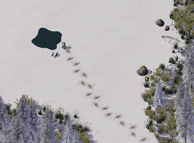
From the album Winter Wonderland (S3-21-M)
For those that fish, a little snow is not going to hold them back. All they need is somewhere to drop a line. -
19 - Augusta Ridge aka Twisting Spine
philforhockey51 posted a City Journal entry in Region of Mountain North (SC4)
Welcome back everyone, it's been awhile since we've had a tour so I hope you enjoyed your break. I've decided to bring us over to another area of the region of Mountain North, an area known as the Six Sister Cities, though they are really just large towns at best. Our first look will be at Augusta Ridge but the locals call the mountain ridge that juts out of the landscape the Twisting Spine. This is going to be a long entry with 45 pictures full of detail so get out the snacks we have a lot to look at. Here is a region shot to show our location: Let's take a look at the city tile in development 02 03 and what the older layout looked like 04 after some work 05 How about we start taking a closer look at some of the areas of the town. Here is the Bridge Area: 06 and the transit area leading into it 07 the Old town area 08 The lower river area 09 10 The New town north area 11 12 13 There used to be one mayor that quite enjoyed the look of a terracotta roof so his home was built on the cliff 14 but the new mayor wanted something a little different with a better view 15 I mean what a view right? 16 Here is the southern circle 17 which crosses over the rail tracks and heads into the hightech industrial area 18 19 This is a fairly busy rail line with rather long trains running on it 20 Which leads to a problem at the station. The train is longer than the station. 21 ^ I think the bear chased the horse onto the tracks but the horse froze at the train at the bear is running away, didn't know there are wild horses in these mountains 22 Here are some shots of a foolish/brave track checker whom decided to go in front of the train as it was pulling out of the station. Think in your head of the Jaws theme baurm baurm baurm ... Run little track checker Run!! 23 24 RUN! 25 taking that curve at speed hope he makes it 26 There are two other areas of industry in town. One is the research center on a piece of land west of the highway 27 and over in the Old town section there is a brewery that has been producing a special brew for decades. It has it's own rail connect to distribute it's brew all over the region. 28 29 Here is the old train station and center of town when there were only a few stores. One is a bar serving the local brew which is of course named Twisting Spine. 30 the circles in the old town mark the first areas of town 31 The west road runs north into a tunnel that runs into the Transit Area shown in picture #06 32 on the other end of the road is the main church in town where the cemetery is on a slope and you can also see the hospital on the hill 33 just below this area is a little sloped area that required a little thought 34 so I did this with it 35 final results a couple of new apartment buildings with what I think is a nice layout with a landscaped slope and stairs 36 Just past the brewery as you're driving out to take the scenic road you will cross over an interesting stretch of road with a nice pier/retaining wall layout 37 Down below this area on the banks of this side of the river there are some recreational areas and houses 38 Here are the trails under the shadow of the mountain 39 Here is a closer look at the boat ramp. ( I used to have the street with the peg dirt or peg gravel SAM but then near the houses it didn't look right. Now the sidewalks don't look right in this area. I wonder if there is a technique for having two different types of SAM streets on the same street, like a starter/blocker piece. 40 and here is the area with some nice houses with boat sheds 41 Here is what the area looks like at night 42 and some of the trailside campsites at night 43 and just a little further down river is a favorite fishing spot 44 Up the river are the bridges and I really like the way these turned out. It took sometime to terraform and then use the rain tool and build the bridge then delete it and terraform some more until I got them to look like this. You can see the rail bridge runs over a drop on the cliff then extends across the river so the bridge looks like it was built to conform to the curves and ridges of the cliffs and the road is at what I remember as the max it can get stretched out without forming another arch under it, typically there are many arches when running that road bridge. 45 That wraps it up for this entry I hope you enjoyed it and I warned you there were a lot of pictures to look at. Please feel free to comment and ask questions and as always don't forget to hit the rep/like button, it takes a lot of time and effort for people to put these CJ entries together so the likes and comments help to make it worth it to share. -

From the album Nature Scenes (S3-19-E)
One day a man had enough, he had enough of the constant noise and stress of city life. He found a spot on the banks of his favorite lake and fishing hole. The only way to get there is by boat but the view and peace and quiet are priceless. Please use the other image size button from the site to better view the details like the house is on piers on a slope and the little bit of wake behind the boat. No photo editing all is MMP work. Sorry no visitors it is a private residence. -

From the album Ancient Civilizations (S3-14-M)
It's the year 1151, a group of monks are working on the Fall harvest. Recently picked grapes are being brought in to be pressed 10 or 20 toes at a time. -

From the album Waterside (S3-17-W)
The wind picks up and the sails fill, out for a day on the water -

From the album Railroads (S3-16-W)
Here we can see a Mountain North Railroad train traveling south on the company's Eastern Mountain Rail Line. Please use the Other Sizes menu at the top right to look at the image in a larger size for more detail. -

From the album City Overview (S3-13-W)
This is the Overview of The Lion's Inlet. The transition of mmp river to in game water and the nestled town next to the marina are some things to look for, the entire shoreline is mmp.- 1 Comment
-
- 7
-

-
- city overview
- challenge
- (and 1 more)
-

From the album Night Scenes (S3-12-E)
Shh! Don't tell anyone. There is a secret airbase in Mountain North. It is hardly ever seen, usually only when a jet is coming in to land and they light up the runway. Here we can see a very rare picture of it. Note the landing aircraft at the bottom and the anti air guns, can't make them out? well it's because it's at night...darknite, and no photo editing. I also have an even more rare photo of it during the day: http://i.imgur.com/XQwdvpt.jpg *some anti air guns were added after day picture was taken that are visible in the night shot I know my picture does not have as many lights and colors as some of the others, but that is the point, this place can't be lit up like a Christmas tree, hope that my effort to intentionally limit the lighting is as appreciated as the scenes with a million lights.- 2 Comments
-
- 6
-
-
- night scenes
- challenge
- (and 1 more)
-

From the album Bridge Bonanza (S3-07-W)
Here is a view of LeBeau Bridge that crosses into the town of Remy's Run. Though the bridge is quite old it does have a bridge keeper nearby and it's not the Gambit some think it is. -

From the album Urban Features (S3-02-E)
The Marina in The Lion's Inlet has a few features among it but as a whole it provides the town with a source of income, entertainment and pride in the town's founder and his foresight to develop the marina area with a lighthouse and a wider channel. -
18 - Sunnyville Part 2 & The Northern Pass
philforhockey51 posted a City Journal entry in Region of Mountain North (SC4)
Welcome back to Sunnyville! It's been a bit since the last post. Seems I ended up all the way down river and missed the van pick up point and then it got dark and I didn't want to sit on the shore waiting for a bear so I let the river take at it's pace till I saw a more populated area near the river. Ok really I was super busy with Real Life and didn't have the time it takes to make these journal entries, for those that don't know it really takes quite a while. Though a lot of the areas are already created in game some lack touching up and some lack pictures plus the time to convert the image then post to share site then this site etc etc.. ramble ramble... Anyway Let's start with a quick look at the District Pic as always Up top in the opening pic we have the Sunnyville Kayak Club from a different angle than the previous post. 02 - The Boat Sheds closeup, seems there is a visitor in the reeds that flew in 03 - The South Side of the town 04 - The Highway Curve and Exit, dangerous? no no can't be? right? no no its fine lol 05 - The Highway Tunnel 06 - Exiting Speed 07 - Road Tunnel 08 - Corner Industry 09 - The Tunnel is newer than the industry 10 - College Circle 11 - Fairview Community Circle 12 - College Exit 13 - In the South East Corner of the woods there is a Logging School and normal the road is not a busy one but people like to go for a drive on Sundays 14 - Logging School closeup 15 & 16 - Someone on this site once asked how to make detailed images, in the next two pictures you will see the before and after of the area of the Logging school. Note that the road was shifted a couple of tiles to the left and some rerouting of the other road curves, a street is now in the two tiles and a SAM PEG Dirt Road starter piece was placed so the base end is next to the lot so it stops flat without a culdesac end. Some MMP changes and now the images details have changed to the better I believe without the streetlight, it's not a busy enough road to merit a light. Before: After: details Ok How about we take a drive up the highway to the town in the tile north of Sunnyville - Northern Pass, which is the northern pass in the mountains that the highway is able to cross. 17 - Zoning and Building and growing some Industry in the corner for the neighbors 18 - Add some Trees 19 - Full Tile Pre-Growth 20 - Full Tile Post Growth some touches need 21 - Final Full Tile View 22 - Just the Town 23 - The main road runs from the highway south into town 24 - Then travels south into a wooded area 25 - Past the Industry and into Sunnyville 26 - On the other side of the highway is a private school that specializes in the environment so it is located both near some industry it can test as well as a vast natural area including waterfalls to it's east that the students can explore.(area can be seen in district pic) 27 - The residential area 28 - Some folks have found themselves a home in the natural corner under the cliff the highway rides up No big ending today sorry. For some of the newer people this is a CJ for the whole region that I am building across, some entries will just lack a major attraction like kayak clubs and and marinas, sometimes land is just used to live and work on, and other than cropping in game pics there is no photo editing everything was downloaded plopped or grown. As always Questions Comments and Likes are appreciated. Note: I might get a chance to post another entry soon before the 1st but if not it will be a couple of weeks into July as I will be away on vacation

