

 Supported
About This File
NHP Kennewick-Pasco-Richland Washington By blade2k5
Map Details and Information
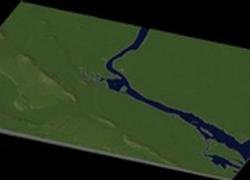
Kennewick is a city in Benton County in the southeastern part of the U.S. state of Washington, near the Hanford nuclear site. It is the most populous of the three cities collectively referred to as the Tri-Cities (the others being Pasco and Richland). Kennewick is located along the southwest bank of the Columbia River, opposite Pasco and just south of the confluence of the Columbia and Yakima rivers. The population was 65,860 at the state Office of Financial Management's estimate in April 2008.
The nearest commercial airport is the Tri-Cities Airport in Pasco, a regional commercial and private airport.
Forbes magazine named Kennewick the #2 area in the United States for job growth, while nearby Yakima was named #1. The article cites the number of scientists employed by the Pacific Northwest National Laboratory and area farmland for this outlook.
Pasco is a city in and the county seat of Franklin County, Washington, United States.
Pasco is one of three cities that make up the Tri-Cities region of the state of Washington. The Tri-Cities is a mid-sized metropolitan area of approximately 230,000 people that also includes the cities of Kennewick and Richland.
The population was 32,066 at the 2000 census. Since that time the city has experienced rapid growth, and the official April 1, 2009 estimate from the Washington State Office of Financial Management puts the city's population at 54,490.
Richland is a city in Benton County in the southeastern part of the U.S. state of Washington, at the confluence of the Yakima and the Columbia Rivers. As of the 2000 census, the city population was 38,708. April 1, 2007 estimates from the Washington State Office of Financial Management put the city's population at 45,070. Along with the nearby cities of Pasco and Kennewick, Richland is one of the Tri-Cities of Washington, home to the Hanford nuclear site.
Map Specifics
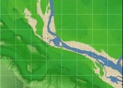
Map Type: Real World
Region map size: Map is configured for 48 large city tiles and is 8x6 in size.
config bmp size: included with zip file
Dependencies: Either SC4 Mapper or SC4 Terraformer for importing.
Maps were created by taking 1/3 Arc USGS DEM elevation data.
Install/Uninstall Instructions can be found in the readme provided.
Credits
blade2k5 - Original map creation, scaling, importing. SC4TF modification.
Check out more maps by blade2k5 and NHP
Any comments and feedback welcomed. Thanks for looking and enjoy.

