

 Supported


About This File
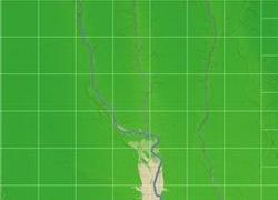
NHP Columbus Ohio By blade2k5
Map Details and Information
Columbus is the capital and the largest city in Ohio. It is the county seat of Franklin County, although parts of the city also extend into Delaware and Fairfield counties. Named for explorer Christopher Columbus, the city was founded in 1812 at the confluence of the Scioto and Olentangy rivers, and assumed the functions of state capital in 1816.
The population was 711,470 at the 2000 census. In 2008, Columbus was the 16th largest city in the United States, with 754,885 residents, and was also the 32nd largest metropolitan area, the fourth largest city in the Midwest, and the fourth most populous capital in the U.S. after Phoenix, Arizona, Indianapolis, Indiana, and Austin, Texas. According to the U.S. Census, the metropolitan area has a population of 1,773,120, and the Combined Statistical Area (which also includes Marion and Chillicothe) has a population of 1,982,252. Columbus is located within 550 miles (890 km) of half of the population of the United States.
The city has a diverse economy based on education, insurance, banking, fashion, defense, aviation, food, logistics, steel, energy, medical research, health care, hospitality, retail, and technology.
Map Specifics
Map Type: Real World
Region map size: Map is configured for 49 large city tiles, 29 medium tiles and is 30km x 30km in size.
config.bmp size: included with zip file
Dependencies: Either SC4 Mapper or SC4 Terraformer for importing.
Maps were created by taking 1/3 Arc USGS DEM elevation data.
Install/Uninstall Instructions: Can be found in the readme provided.
Credits
blade2k5 - Original map creation, scaling, importing. SC4TF modification.
Check out more maps by blade2k5 and NHP
Any comments and feedback welcomed. Thanks for looking and enjoy.


