

 Supported


About This File
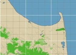
NHP Cape Henlopen Delaware By blade2k5 and papab2000
Map Details and Information
Cape Henlopen is the southern cape of the Delaware Bay along the Atlantic coast of the United States. It lies in the state of Delaware, near the town of Lewes, Delaware. Off the coast on the bay side are two lighthouses, called the Harbor of Refuge Light and the Delaware Breakwater East End Light.
Originally spelled Cape Hinlopen, Cape Henlopen is named after Thijmen Jacobsz Hinlopen who was a prominent Dutch trader in corn from the Baltic carrying on trade to Genoa and Portugal. He also was an insurer and a director of the Northern Company, involved in whaling and participant in the New Netherland Company, interested in furs. Cape Hinlopen was New Netherland's most southern border on the 37th parallel.
In 1620, Thijmen Jacobsz Hinlopen became Cornelis Jacobsen Mey's (the now washed out Cape Cornelius and the incorrectly spelled Cape May) business partner in the ships Blijde Boodschap (en. "Joyful Message") and Bever which focused on exploration and trade with the Indians in the Zuidt Rivier (Delaware River) in 1620.
The area between the 38th and 40th parallels (i.e., the Delaware Bay area) as well as the Delaware River from north to south had previously been surveyed and charted by Cornelis Hendricksz from Monnikendam on the ship "Onrust" in 1614, 1615 and 1616. From August until November 1616, the New Netherland Company, which had an exclusive trading patent for the New Netherland territory between 40 and 45 degrees latitude, had tried unsuccessfully to obtain an exclusive patent from the States General of the Dutch Republic for the territory between 38 and 40 degrees latitude.
Cornelis Jacobsz May was also unable to trade in the South River (Delaware River) at the exclusion of competing Dutch companies. Those Dutch companies came in conflict with one another but were eventually able to reach agreement in New Netherland. Discord arose again which was settled, finally, by a judgment of arbitrators at Amsterdam on December 23, 1623. The 38th and 39th parallels region came under the final jurisdiction of the Dutch West India Company on behalf of the States General with the delivery of the first settlers to Governors Island in New Netherland in 1624. Those settlers were subsequently spread out onto Verhulsten Island (Burlington Island) in the Delaware, at Fort Orange (now Albany) in the Hudson River and at the mouth of the Connecticut River in order to finalize the claim to New Netherland as a North American province according to the Law of Nations (Hugo Grotius).
Cape Henlopen State Park is a 5,193 acre (21 km²) Delaware state park on Cape Henlopen in Sussex County, Delaware, in the United States. William Penn made the beaches of Cape Henlopen one of the first public lands established in what has become the United States in 1682 with the declaration that Cape Henlopen would be for "the usage of the citizens of Lewes and Sussex County." Cape Henlopen State Park has a 24-hour and year-round fishing pier as well as campgrounds. The remainder of the park is only open from sunrise to sunset, and includes a bathhouse on the Atlantic Ocean, an area for surf-fishing, a disc golf course, and bicycle and walking paths. The beach at Herring Point is a popular surfing spot.
As with all Delaware state beaches, entrance is free during the off-season but costs $4 for Delaware-tagged vehicles and $8 for out of state vehicles from 1 May to 31 October. Season passes may be purchased at a cost of $27 per in-state vehicle and $54 per out-of-state vehicle. These passes provide access to all state beaches and parks in Delaware.
Map Specifics
Map Type: Real World
Region map size: Map is configured for 9 large city tiles and is 3x3 in size.
config.bmp size: included with zip file
Dependencies: Either SC4 Mapper or SC4 Terraformer for importing.
Maps were created by taking 1/3 Arc USGS DEM elevation data.
Install/Uninstall Instructions
Installing the Map
To install SC4M map file:
1. Unzip this file.
2. Run SC4Mapper, click on 'create region'
3. Choose SC4M
4. Browse to the unzipped folder and point the map file .SC4M
5. Click on 'Save Region' and name it, and Quit SC4Mapper
6. Run SC4 and load the new region. The colors of the region in SC4 will be the same colors as SC4Mapper until you enter and save each city tile. But you have the choice to do it as you go and not right away.
SC4Terraformer
1. Create a new region folder in your Plugins\Region
2. Copy my config.bmp into the folder and overwrite the old one. (make changes to config.bmp file now if you want)
3. Open the new region you just created with SC4 Terraformer
4. Click on Import Image in the Global Tools Menu and browse for my SC4M file.
5. When file is imported click File - Save (the region is now saved to SC4
6. The colors of the region in SC4 will be the same colors as SC4TF until you enter and save each city tile. But you have the choice to do it as you go and not right away.
Start opening tiles!
Credits
blade2k5 - Original map creation, scaling, importing. SC4TF modification.
papab2000 - Original map creation, scaling, importing. SC4TF modification.
Check out more maps by blade2k5 and NHP
Any comments and feedback welcomed. Thanks for looking and enjoy.


