Jump to content
  •   Announcement

  • Entries
    6
  • Comments
    80
  • Views
    1,164

Generations of Early Expansion ~ Part 1

Daeris

1,569 Views

Various Issues brought to discussion during the leaders recent gathering (mentioned at the end of post):  

12 members have voted

This poll is closed to new votes
  1. 1. Available flatlands and freshwater for farming are limited. Where should the leaders send settlers to look for more fertile land?

  2. 2. Tidehook, Slyside Lake, and Port Novel all have ports now. Should we spare a fishing ship to send settlers to settle new land?

  3. 3. Where did we come from? What is beyond these lands? Should we send an ambitious scouting party to the farthest edges of the region, searching for other civilization?


  • Please Sign In or Register to view and vote in this poll.
  • Poll closed on 01/13/2021 at 11:15 AM

Previously on Uncovering Junon Vale:

  • Settlers had awoken in this strange new land.
  • Port Novel was founded! ~ Families farm and hunt and fish.
  • From Port Novel: Explorers were sent by ship to map the waterways. Explorers were sent by foot south to settle coastal flatlands. Explorers were sent east to settle flatlands and explore a ravine. The haunted forest is clearly much too haunted for exploration *:lol:!
  • Northbite was founded!
  • Midfin was founded! ~ They are stubborn and think their peninsula is a shark fin not a shark tooth
  • Southpath connects Port Novel to Northbite.
  • Sharktooth Trail runs through the southern sharktooth-like peninsulas
  • The ship of explorers returned from their monthslong journey, bringing a mindblowing map of the region and all its waterways. Of course, there is no way to know what awaits inland... until we go explore and settle those lands! ~ A new hidden lake is discovered relatively close!

The area surrounding Port Novel:
5ff907a11d82f_ScreenShot01-08-21at09_38AM.JPG.2109cd3da84241a20910e6e3b5e7ccec.JPG


For a generation, the settlers who awoke on the beaches built up their homes and their community, domesticating animals and, making the woods surrounding Port Novel theirs. It was an endless job of survival at first, but in time they grew comfortable with their surroundings and decided to explore the region. The next many generations of our settlers would continue this task, growing their families larger, expanding their villages, and seeking understanding and discovery of the land and their purpose.

e161d573eb8616af64bbba0108f58d06.png.8a7f1ab99340076665e24f858906228d.png
(artwork by andanguyen.deviantart.com)


After learning of the nearby hidden lake, settlers were quickly sent south along the Southpath to a nearby valley that seemed to veer towards the lake. They would begin to lay a trail down:

5ff90fce2ff1f_ScreenShot01-08-21at06_29PM.JPG.12160f75f7fbf3f538a6fceeadc36717.JPG


After making some progress, the explorers were absolutely amazed at the lakeside valley they discovered:

5ff910183d960_ScreenShot01-08-21at06_32PM.JPG.851edbd79075b19c70119593296b92f8.JPG

It was immediately very clear this would be an excellent place for farming, fishing, and just a pretty darn sweet spot to live *:ohyes:. Who doesn't want to wake up next to a hidden lake every morning? This generation of expansionists decided to start building up a community right away. Word spread very quickly of the idyllic conditions of the hidden lake valley.


Meanwhile, east of Port Novel, the explorers tasked with venturing into the irresistible ravine were making good work laying down their trail along the traversable terrain. While doing so, they discovered another valley/ravine heading north. It would remain unexplored for now, though it was certainly a promising spot to the north, and hey this forest doesn't look haunted at all! So it's got that going for it *;).

5ff9133238ac1_ScreenShot01-08-21at06_22PM.JPG.40c10e4b46b67dccf2903d184548a7bb.JPG


It's toilsome and rough land, but in time the path snakes its way through the hilly landscape:

5ff915306c484_ScreenShot01-06-21at03_29AM.JPG.d6c34e7485a51ea6cd4874e829272b63.JPG

5ff91549a1144_ScreenShot01-06-21at03.29AM001.JPG.8e639537e562082e03064bb5fd661f28.JPG


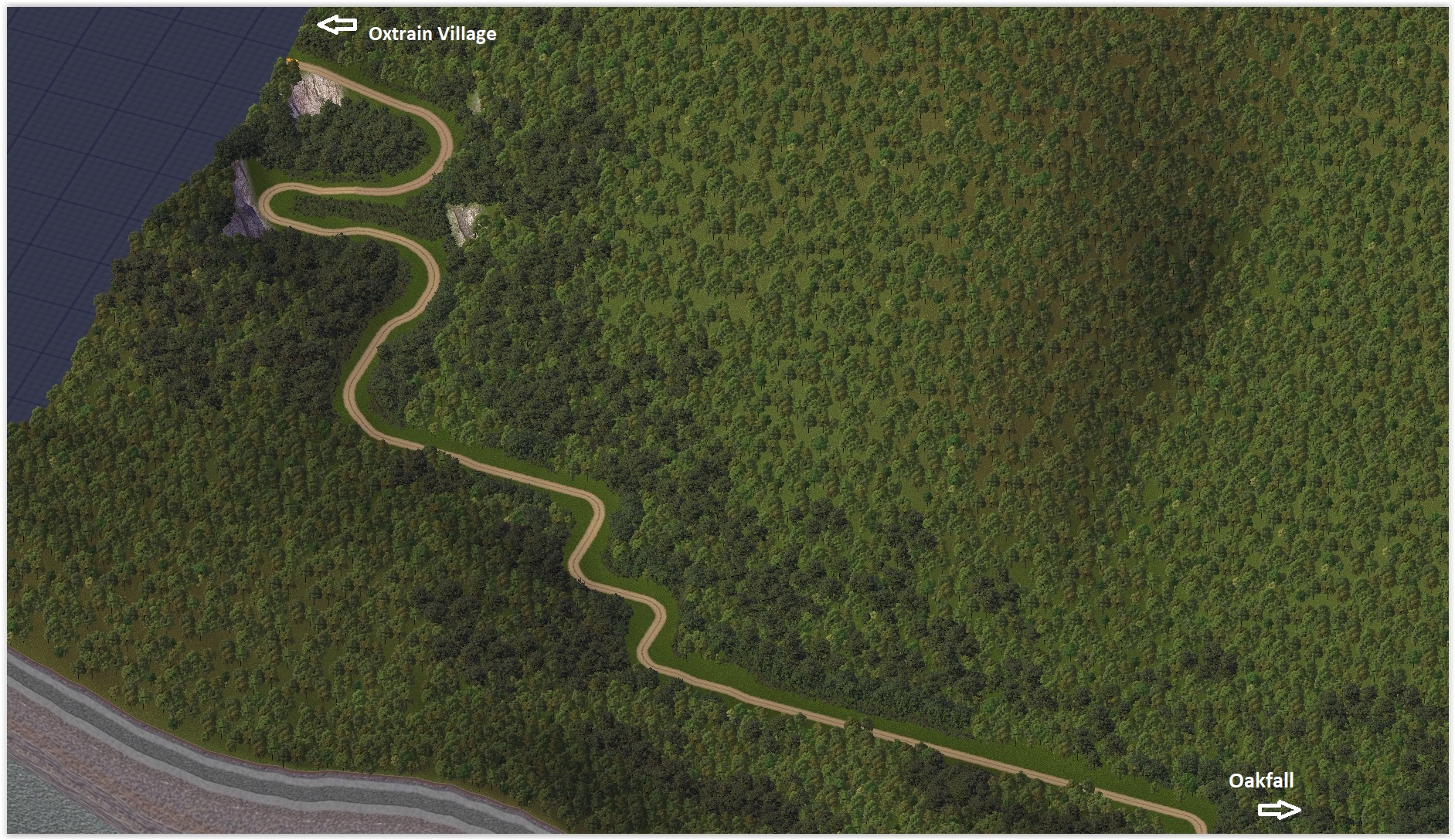
Sadly, as the months passed, it became commonplace for many of the more clumsy trailblazers to fall from various precipices along the path, leading to injury or death (usually while hauling supplies). The supplies needed for laying a trail of this nature were mountainous in their own right. It became paramount for teams of oxen to haul the supplies and tools, as well as food & water needed to sustain our brave pathmakers as they ventured deeper into the land. As such, the path through the ravine became known as the Oxtrain Pass.

Over time, a pitstop for supplies, and a last respite before the ravine took root near the trailhead.

Oxtrain Village founded:

5ff9181f9f0a8_ScreenShot01-08-21at06.22PM001.JPG.13569230a938d2a23c2ed7d7bdf0764b.JPG

5ff91821a2db3_ScreenShot01-08-21at06_21PM.JPG.3e58ff4af103dba19258f90a618bded0.JPG


Oxtrain Village was a busybee place in its early days, with various stableboys washing and setting up tack for horses and oxen. Here was the main stable that took root at the trailhead to Oxtrain Pass:

5ff9175675d36_ScreenShot01-08-21at06_23PM.JPG.7e80831e8fed92ea34afa681a57f5fc2.JPG


Pastures were also abundant for the many beasts of burden stabled in these parts:

5ff9175413519_ScreenShot01-08-21at06_25PM.JPG.08442b4247eb63646b7b0bc59873c577.JPG

5ff91751c9d93_ScreenShot01-08-21at06_26PM.JPG.058b620701dc5ede281b0c177e6218e8.JPG

Many travelers agreed the village was a great spot to rest sore feet, although it did always smells a little funny for some reason... *:lol:


Meanwhile, the idyllic community by the hidden lake has blossomed into quite a desirable spot.
 

Slyside Lake foundedNamed for its sly-like hidden nature, Slyside Lake becomes a migratory location, pulling families from some of the other established villages.

5ff9311cac9f5_ScreenShot01-08-21at11_25PM.JPG.2e65834aeb59ec438fa39d37677f124e.JPG
5ff92dee92fbf_ScreenShot01-03-21at10_26PM.JPG.20e12296f88ceecb0529d72594b8e306.JPG

5ff92da0955f9_ScreenShot01-08-21at06_34PM.JPG.169352e8abb7415d7ca2ba7646fdb7a1.JPG

5ff92df0c83a5_ScreenShot01-03-21at10_28PM.JPG.ed127b5c3e497f2818d76b9a90fca1a6.JPG

5ff9311a3a4d1_ScreenShot01-08-21at11_26PM.JPG.d1997ff499f07762e3741c3cf2038482.JPG


With growing families in Northbite and Midfin, the need to continue expansion even further south along Sharktooth Trail is commenced. As time passes, many new coastal towns make a move.


Sharpbend Foundeda small village on the southernmost "sharktooth" (or shark fin according to Midfin *:lol:)

5ff932e40b329_ScreenShot01-05-21at03.56AM001.jpg.a116bd952e3635597da4fde009299fa4.jpg

5ff932e7ea9a4_ScreenShot01-05-21at03_57AM.jpg.6c2d97c9e999e95f7a590c8400b5ec41.jpg


Pebbleplum Foundeda narrow little cliffside village along the coast, further south of Sharpbend. Aptly named due to all the pebbles that frequently plummet from the looming cliffs. Sore heads are quite common in Pebbleplum, but hey if it doesn't kill ya' it makes your head stronger. :]

5ff932e19d136_ScreenShot01-05-21at03_55AM.jpg.8bf04f75cc2ee79eefc9f5a6775cebf9.jpg

5ff932e6549f4_ScreenShot01-05-21at03_56AM.jpg.5c05f1e1e819f171e97678b4bf8b435b.jpg


Tidehook FoundedNamed such for the way the tide hooks around this large peninsula, as the water flows out from the large unnamed river (which itself comes from deeper inland).

5ff932e96ecca_ScreenShot01-05-21at03_58AM.jpg.77b55997226cbb926cc94176dd5d333c.jpg

5ff932edb3d44_ScreenShot01-05-21at04_01AM.jpg.c789e95f91de88426579f35c25444cde.jpg

5ff932eba78dc_ScreenShot01-05-21at04_00AM.jpg.1193f2e347bb42bc3c7673a642ab2d6f.jpg

5ff9320398f33_ScreenShot01-08-21at06.37PM2.jpg.6d30a62d98dc30d83929ea8c2738bb97.jpg

5ff93684cb321_ScreenShot01-08-21at06_39PM.JPG.ae5baf098145217f348a60ec66b95a5a.JPG


Finallyafter much blood, sweat, tears (and oxen poop), the Oxtrain Pass busts through the rough hills and descends into flatlands once again. Other than groundwater, there is no larger body of freshwater nearby however.

Oakfall FoundedMuch like Oxtrain Village (on the other terminus of Oxtrain Pass), Oakfall is a town where all eager explorers rest their weary feet after making it through the rough mountain path in one piece. It's said once a traveler makes it hear from Oxtrain Village, the fall right on their face like a falling Oak in the forest. Also, most folks agree Oakfall smells way better than Oxtrain Village *:yes: (but not by much).

5ff9396a6b9f7_ScreenShot01-07-21at05.17AM2.jpg.7b032b552a651a9157ee3d58e084dbef.jpg

5ff939686a581_ScreenShot01-07-21at05.17AM001.jpg.82ea63a5aa2f0528e77a7e8f9a011177.jpg

5ff93963b0e0e_ScreenShot01-07-21at05_18AM.jpg.5caf74fed473f9b74610c274500308d0.jpg

5ff9395d94cca_ScreenShot01-07-21at05_23AM.jpg.3d3d88e78418c346bc539d54baebe6ff.jpg

^Wagon trains tacking up and loading up for the trip back to Oxtrain Village

5ff93c21ac7c1_ScreenShot01-07-21at05.12AM0012.jpg.dead87e15ab1f1b4df009e341ed2a98e.jpg

5ff93961eac2c_ScreenShot01-07-21at05_12AM.jpg.bff9037f641ee01e4de11e644dbaa24c.jpg


This generation is off to an ambitious start exploring and expanding! The leaders, having been updating their maps often, convene to consider the next courses of action.

Some of the ongoing topics of discussion during this gathering are:

  • Available flatlands and fresh water for farming are limited, while families continue to grow and grow and grow! What are these settlers, part rabbit? *;)
  • With Tidehook, Slyside Lake, and Port Novel, we now have 3 growing port communities. Most ships are being used for fishing, but perhaps we should send a ship of settlers to settle across the bay? To settle on the large island south of Slyside Lake? To settle elsewhere?
  • What is beyond these lands? Where did we all come from? Perhaps we should send an ambitious group of scouts to the farthest edges of this region, searching for other traces of civilization?

Updated map:

5ff9434c3aed3_JunonVale010921(fogofwar).jpg.237c6283f31be4058d178fc3453caf6b.jpg


A closer look at the immediate area:

5ff94345793b6_ScreenShot01-09-21at12_46AM.JPG.db2c4e4f9ae4b698104cb27fc83c39cb.JPG


Updates of Uncovering Junon Vale:

  • An unexplored ravine heading north (perhaps past that spooky haunted forest) was found while laying trail for Oxtrain Pass.
  • Oxtrain Village is founded! ~ It smells a little funny, but it's ok
  • Slyside Lake is founded! ~ "Can we go there, Can we go there?" cry all the settlers.
  • Sharpbend is founded!
  • Pebbleplum is founded! ~ Today's forecast is 60% chance of light stony rain
  • Tidehook is founded!
  • An unexplored island calls to many of the sailors of Tidehook, as do the lands across the bay (Wait, are those mermaid calls? This should be safe, right?) Or should they explore the giant island southeast?
  • Oakfall is founded! ~ smells much better than Oxtrain Village
  • Oxtrain Pass connects Oxtrain Village and Oakfall.


  • Like 12
  • Yes 2
  • Thanks 1


19 Comments


Recommended Comments

I have just read the first two entries in this CJ and I am quite intrigued by this. I've been following the thread about natural growth and I find it to be fun and quite fascinating as well.

Good job here! :8) keep up the good work!

  • Like 5
  • Yes 1

Share this comment


Link to comment

Fantastic journal @Daeris. The fog of war concept is a very novel and captivating way to tell your region's story.

I like how low-key the early settlements look like. That's a good way to represent early developments.

Where did you get the art piece from? Your own creation? *;)

Makes me wanna start my own diary. I think I will soon... No idea though how will I manage a diary and New Magnasanti though. :(

  • Like 5

Share this comment


Link to comment

I think the only thing to be nervous about @Daeris, is keeping up with the comments and questions you will receive. The views and story reminds me of the struggles setters faced when trying to establish land in the Hoosier National Forrest area in Indiana. (All but the seaside.) Very rough and hilly terrain and tough going. So bad, a lot gave up and abandoned their make shift farms and houses. The government stepped in and bought up the vacant and rapidly eroding land and reforested it.  The land was made for public use. Areas of the Hoosier Forest was so tough, glaciers could not move past them and went around, some long, long time ago.... So my point is, it looks real and natural. Good job.

  • Like 5
  • Yes 1

Share this comment


Link to comment

Wow, again thank you all so much for the confidence boost.

1 hour ago, TheMurderousCricket said:

The fog of war concept is a very novel and captivating way to tell your region's story.

Thanks, yeah it was an interesting idea that came to me and I hadn't seen it done yet. Maybe it's something other seasoned city-builders would like to try and expand on (I'd be curious to see). I'm not sure how of how to fully use it yet, but I was hoping it would provide a sense of mystery and make the viewers feel more like the settlers do. I'm also completely open to unique ideas on how to get creative with the fog-of-war mechanic.
 

1 hour ago, TheMurderousCricket said:

Where did you get the art piece from? Your own creation? *;)

This concept piece is from andanguyen.deviantart.com

Hopefully it's ok to share concept pieces like this. Perhaps I should be fully crediting and linking the artist?


8 minutes ago, Kloudkicker said:

So my point is, it looks real and natural. Good job.

Thanks Kloudkicker (and thanks for explaining about similar real-world struggles), I'm also open to ideas about realistic struggles and events that might happen. Usually I'm decent about things kinda coming to me on the fly, but it certainly doesn't hurt to have friends helping you brainstorm, so if you think of anything you'd like to see in the future polls (to allow viewer interaction), send me a DM or comment and I can consider including it! :)

  • Like 4

Share this comment


Link to comment

This thought just came to mind..... It would be cool to have a CJ that could helped be built by others. A whole region premade, and small areas sectioned off on different city tiles. They cities could be started or not but then sent to a willing player to build in the predetermine area in the city. And when done sent back to be updated into the region. A interactive CJ, kind of like the way it was on the Maxis site. If planned right it could be fun and a way to do something different for a little while. Could be a handful also for the host of the CJ. Not implying this one, just a thought I wanted to share.

  • Like 3

Share this comment


Link to comment
2 minutes ago, Kloudkicker said:

This thought just came to mind..... It would be cool to have a CJ that could helped be built by others. A whole region premade, and small areas sectioned off on different city tiles. They cities could be started or not but then sent to a willing player to build in the predetermine area in the city. And when done sent back to be updated into the region. A interactive CJ, kind of like the way it was on the Maxis site. If planned right it could be fun and a way to do something different for a little while. Could be a handful also for the host of the CJ. Not implying this one, just a thought I wanted to share.

That's a cool idea, I definitely love the idea of other users helping to shape things in an interactive way.

  • Like 3

Share this comment


Link to comment

Oh so much great voting! It's looking like the next courses of action will be underway soon. Thank you all for voting (more votes are still welcome if you haven't already done so)!

  • Like 3

Share this comment


Link to comment

Really cool to see the story of how the settlers began exploring, and how by voting we can shape what happens next. It's a bit like venturing back in a time machine and watching how all this will unfold. The hidden areas on the map add a certain mystique about them, with excitement for them being revealed after further discoveries are made. *:)

For my votes, I went with:

  1. East of Oakfall:  I figure the more fertile land will be beside water, much like the River Nile is for African settlements.
  2. Great Island below Slyside Lake:  To be "great" and that means it's rather large and will surely be worth the trip.
  3. North through the unexplored ravine:  Maybe there could be some mining potential up there, such as gold or other precious minerals.


  • Like 4

Share this comment


Link to comment

I like every part of your concept and the execution of it. You are creating a region more realistic than I ever did. (I'll need to borrow your concept for the next new one I start.)

You have a good talent for the development blended in with the storytelling and the pictures to go with it. I really like the Oxtrain Pass as it twists and turns as needed to follow the height of the land. It is so squirrelly that later when modern cars drive on it they'll be able to see their car's headlights in the rear view mirror.

  • Like 3
  • Yes 1

Share this comment


Link to comment

I'm impressed by this city journal! Strong start with a lot of thoughtful details for an engaging experience. The fog-of-war concept makes the whole thing that much more enticing, and helps hide the juicy ideas and projects until they're ready for their debut.

  • Like 5

Share this comment


Link to comment

@Daeris, One of the things I hope to make someday is a recreation of the old Grand Kankakee Marsh that was in Northern Indiana. It was considered, at one time, to be the largest marsh in the United States. Larger than the Everglades in Florida. This was until the river basin that supplied the marsh, wetland, swamp and bogs with water was trenched to make way for very fertile farm land. The Kankakee River itself started out, before man came along, as a 280 mile, winding river running thru Indiana to the neighbor of Illinois. After the "straitening" of the river, dredged and retrenched, made the river only 90 mile to the border. The northwest part of Indiana is just filled with drainage diches. There're are small parts that are being restored but the damage has long been done. There was said to be flocks of herons in the millions that stopped on its migration through. It was so large, that the Spanish Conquistador's tried to go thru and was faced with a unbeatable challenge, the marsh. Daily marching went from 12 or 13 miles a day down to 2 miles a day when they entered the marsh. After 2 weeks in the marsh, they said F' this and went home. The Spanish were on a really long trip to find gold, a multi year wild goose egg hunt when they were in the US. All the Indian tribes they encountered said the gold was in the next village. The trip stated in South America were they got the 'gold bug' from and ended in the Grand Kankakee Marsh. 

Says so what I have read. I cant find the old links I had.

Maybe if Cori and CB found some time down the road, they could whip up some of the maps they have stashed away. It would help in this ideal to have some older maps. No rush thou.

  • Like 3

Share this comment


Link to comment
3 minutes ago, Kloudkicker said:

Maybe if Cori and CB found some time down the road, they could whip up some of the maps they have stashed away.

I presume you are referring to all the old 1876 maps I downloaded for every county in Indiana and mentioned in Daeris's thread?

I posted a linky there to the site. While I imagine I could post any given map in the context of reviewing it and commenting how I'd adapt that myself to the game, I'm fairly certain I can't just share the whole batch of them. (So, I won't.) *;)

  • Like 2

Share this comment


Link to comment
8 hours ago, Daeris said:

Hopefully it's ok to share concept pieces like this. Perhaps I should be fully crediting and linking the artist?

Indeed, I think you should. *;) This is why I asked. This may be important for some of them.

A non-profit use of someone's work should generally qualify as fair use, but some credit is always nice.

  • Like 4

Share this comment


Link to comment
1 hour ago, TheMurderousCricket said:

A non-profit use of someone's work should generally qualify as fair use, but some credit is always nice.

Indeed. I'm actually a videographer and photographer irl, so I should absolutely know and do better.

  • Like 2
  • Thanks 2

Share this comment


Link to comment

Great CJ - would you care to share which harbour plugins you are using? I'm in need of this kind of harbour pieces for my own CJ ... thank you!

  • Like 1

Share this comment


Link to comment
14 hours ago, Rady said:

Great CJ - would you care to share which harbour plugins you are using? I'm in need of this kind of harbour pieces for my own CJ ... thank you!

Hi @Rady, I believe what you're looking for is Historic Harbors:


  • Like 2

Share this comment


Link to comment

Sign In or register to comment...

To comment in reply, you must be a community member

Sign In  

Already have an account? Sign in here.

Sign In Now

Create an Account  

Sign up to join our friendly community. It's easy!  

Register a New Account

×

Thank You for the Continued Support!

Simtropolis depends on donations to fund site maintenance costs.
Without your support, we just would not be in our 24th year online!  You really help make this a great community. *:thumb:

But we still need your support to stay online. If you're able to, please consider a donation to help us stay up and running. This helps sustain a platform where we can share our community creations for years to come.

Make a Donation, Get a Gift!

Expand your city with the best from the Simtropolis Exchange.
Make a Donation and get one or all three discs today!

STEX Collections

By way of a "Thank You" gift, we'd like to send you our STEX Collector's DVD. It's some of the best buildings, lots, maps and mods collected for you over the years. Check out the STEX Collections for more info.

Each donation helps keep Simtropolis online, open and free!

Thank you for reading and enjoy the site!

More About STEX Collections