-
Announcement
-

Simtropolis Returns! 05/26/2026
See here for details about our site recovery efforts.
-
Search the Community
Showing results for tags 'village '.
Found 2 results
-
Welcome back to Province! Today, however, will be something different. While I was headed to Province from Chav'villa a group of tourists wanted to take me on a circle tour through the mountains instead of going via Highway Of The Mountains (designated Moneyland Highway-100 or ML-100 for short). I initially refused, but seeing that I could get my hands on some great pictures I decided to go with them in the end. (All captions are BELOW the pictures) The group that I was to meet told me to meet them at the corner of Saint Andreas and Stadium Avenues in Abalazone Park. Not exactly the best-looking place in the world, so I was a bit paranoid. However, it turns out they were nice folk after all. After all, if it turned into a kidnapping wouldn't I have just put "JOURNALIST KIDNAPPED!" as the title instead? Huh? While we drove southbound Saint Andreas Avenue, above our heads we saw the Red Line Province Metro making its journey. The Metro trains were initially built by the National Rail Co., headquartered in Abalazone Park back in the 1960s. NRC later went bankrupt along with almost every other company HQed in Province in the 1990s. To the right of the train is a freight train inbound to the Brotherhood Ave. Freight-house. Driving forward on Saint Andreas past the Brotherhood Ave. intersection, we find ourselves at "Tunnel Junction" as the locals say it. To the right is the Wotton High district, full of british-style streets and terraced housing. However, we go left, into the tunnel underneath ML-100. The ML-100 is known as Highway of the Mountains in Province and carries more than 100,000 cars daily from the suburbs to the CBD and Province Strip. Unfortunately, it is due for an upgrade as it only has 4 lanes and is frequently congested. A closer look at the tunnel. The Ste. Andreas Tunnel was constructed in 1989 as a way for traffic to get across ML-100 without an overpass, which would've been stupidly high (around 35 meters). Before 1989, the freeway didn't exist, as ML-100 was actually designated through Sainte Andreas Avenue and Morgan Street. However, the Bill of1988 passed by the federal government required the hold of Jiff to construct ML-100 as a freeway through their state. Today, ML-100 spans from the East-to-West coast as a completely divided freeway from Greenland to Chav'villa Holds. As we emerged from the other side of the tunnel, I leaned out of the side to take this photo of the city. Welcome to the countryside of Jiff Hold! Sure looks different from the city. We are at the foot of Mount Province. A few moments later the paved road turns into a dirt one. Now we're talking. v This section of land is going to eventually be transformed into farmland by 2041. However for now it's just a gently rolling plain. The building on the top right is the Overlook Hotel, which is where we'll eventually come to. Looking back again. We eventually come to a crossroad.The tourists don't know which way to go, so we decide just to go right and see what's there. Welcome to Audrey! Population: 0! Hmm... not what we were expecting. Audrey was a small village constructed in 1765 after travelers from the U.S. settled in the area. However, extreme coldness, lack of food, along with the unforgiving wildlife soon killed off all 25 settlers. Fast forward to 1895- Province had been established for around 35 years. The city voted to pass the Law of Trash, or legally called Bill XIV. The Law of Trash basically turned Audrey into purely a landfill/incineration site. There were 2 incinerators and 6 landfills to start off with, however as the population exploded in 1950 the landfills were converted into incinerators. In 1960 and 1963 two Nuclear Power Plants were added to the site. After realizing our mistake we did a U-turn and turned onto the other road, Mountain Rim Rd.. This hill pictured is called Grabbage Hill- named after James C. Grabbage, the original founder of Audrey in 1756. Ironically, Grabbage is only a letter swap and a letter removal away from Garbage. Jokes aside, Grabbage Hill has a gradient of 45%- so naturally even our 4x4 Ford Raptor struggled to get up this monstrous hill. People normally do not take Saint Andreas up due to these extreme gradients. Continuing on, we see our first glimpses of an actual forest. While Jiff in general has a generally taiga climate, forests are not too common. In fact, more than 65% of the hold is unforested. Trees brush up against our truck as we continue to struggle up this road... And we have our first glimpse of the city from a height! Province is already at an elevation of 5,600 feet, so the air is getting thin around here. We hand around chapstick because we've never been so high. Here, the GPS approximates around 6,300 feet in elevation. The Atlantic Ocean only about 40 miles north of Province, so as expected there is a massive, 3,000 foot cliff drop-off into the sea. These gargantuan cliffs are extremely secluded, as no roads go near them and the only known settlement there was Jaquesville back in the 1700s. The people there vanished without a trace 20 years later and it is still a mystery today. It wouldn't be a road in Jiff without a steep incline and a pickup going down it on the other side... Another look at Province from here, elevation around 6,600 feet. You can clearly see the suburbs on the left, the CBD and Revolution District in the center, Abalazone Park on the right with the stadium, and the Province Strip with all the hotels and skyscrapers on the far right. On the far left you can see Christchurch, a small farming town and a suburb of Province. After driving a few miles or so, we finally come to the Stocking Bridge, a wooden bridge built on the side of Mt. Province. After concluding that an at-ground design for the road was impossible, engineers designed one of the most iconic bridges in Province. After driving for some time on the bridge we can have the best look at Province we have seen yet. After driving the 500 feet long Stocking Bridge we encounter Stocking Cut, one of the most challenging climbs for our trusty truck. Another view of the Stocking Cut to show the 500 feet long 40% gradient hill. After climbing the huge cut and driving for several more miles, we encounter a scenery change. Gone are the pine trees that we saw earlier. Instead, we are greeted by a barren tundra. Temperatures at this altitude, 7,900 feet above sea level, are shockingly cold this far north. In the summer, temperatures are normally around 48 degrees fahrenheit (8 degrees celsius), while temperatures in the winter usually reach a bone-crackling -5 degrees fahrenheit (-20.5 degrees celsius). This constant frigid weather along with unique composition of the soil stops all vegetation from growing. The summit of Mt.Province is around 8,100 feet high, just a few miles down the road. Welcome to Summit Camp Village! The "village" only has two buildings- a Shell gas station and the Overlook Hotel. The Overlook Hotel is a 5-star rated hotel that offers breathtaking views -- for a price... Conveniently there is a parking lot next to the breathtaking viewpoint- and a guardrail! Whew, wish there were at least some on Mountain Rim Road... Looking over the south side of Mt. Province. As you can see, the land is largely untouched. This is actually one of the few places you can catch a glimpse of "Hidden Valley", a completely uninhabited area between Mt. Province and Mt. Monroe, the biggest mountain in the Monroe Mountain Range. Another look at the Overlook Hotel. Although we didn't necessarily want to spend a night there, we decided to ask the staff there to look at the view, who were kind enough to lead us to a suite with a giant window. Needless to say, it would be fantastic to come here at night and watch the city light up. Leaving the hotel, we decide to continue up the road to the summit. Strangely enough, there is no sign or even flag to signal the top of Mt. Province. The road is extremely desolate here between Summit Village and Base Camp Village, our next destination. The only building we see on the 5 mile trek is this giant incinerator. This building is the Skagate Incinerator, built in 1913 by the town of Skagate. Skagate later changed name to Base Camp Village, due to it being a base camp for trekkers hiking to the summit. In 1793 the first person ever to ascend Mt. Province was James G. Skagate, for whom the town was named after. The Skagate Incinerator is still operational today, although safety concerns have been raised. After driving for around 15 minutes (seemed like an eternity when all you see is desolate plain and a dirt road with very little traffic) we finally arrive at Base Camp Village, Population 2,235! Downtown Base Camp Village on Mountain Rim Rd. Despite being at the top of the world, literally, Base Camp Village is no utopia. Most people who live here are undereducated and the real estate business here is not great. In fact, the average salary here is only around 32,000MD (or around $16,000). James Skagate Elementary, the only school within 10 miles from here. We come up to the only traffic light for about 10 miles- the intersection between Mountain Rim Rd. and the Skagate Hwy. We will turn left onto the Skagate Highway in order to get back to Province. However, first we check out some of the residential housing in Base Camp Village. We turned right at the light to get to the residential housing. Another picture of the housing, And yet another one. We loop back around to the light again, this time on Mountain Rim Rd. First, we make a pit-stop though. This is the Skagate Church, the highest church in all of Jiff. By the way, Base Camp Village (at 8,000 feet above sea level) is also the 4th highest community and 2nd highest incorporated community in Jiff. Looking back at Base Camp Village while we escape via the Skagate Hwy. this road is much more traveled by since it has less steep gradients. Travelin' through more desolate treeless land. We are finally descending back to Province-level (which is what the locals here call 5,600 feet, or the elevation the CBD of Province). ...And more Hmm...A postal truck.... interesting. The MLPS (Moneyland Postal Service) only started to serve Base Camp Village in 2007. *It's getting late here, so I'm going to have to cut this off. I've been working on this post an hour at a time today whenever I wasn't playing C:S so I'm ready to take a break* To be continued tomorrow...
- 6 Comments
-
- 4
-

-
- cities skylines
- mountains
- (and 4 more)
-
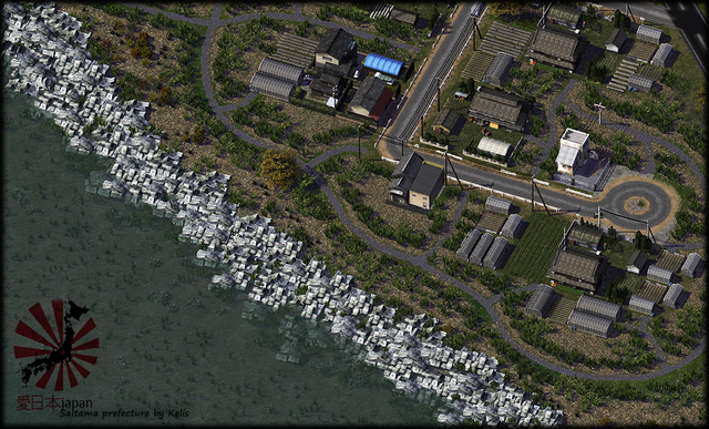 A small village located pretty close to Hatsukaichi main port