


Cresset River: Overview

Cresset River, centrally located in the region of Tuentia, is the area’s largest city. This was the first city I created in this region (and my first time returning to SC4 after a few years away), so unlike many other cities in this region, it didn’t have much of a plan and has expanded pretty organically. At this point I've filled a little over half of the available space, and most neighborhoods and suburbs are established except for areas in the north and southeast.
Overview
- City tile size: Large
- Current game date: 10/5/81
- Population: 161,149
- Jobs: 62,129 C and 20,309 I

City overview
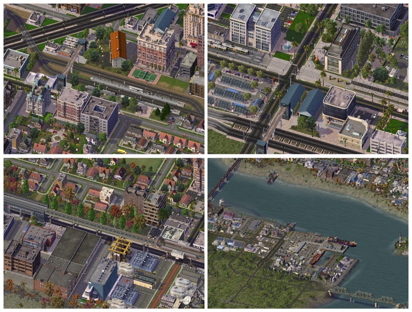
Cityscape

Clockwise from top right: downtown; new development across the river from downtown; the university; and the west side.
Geography
Cresset River lies on both banks of a large navigable river of the same name. The river flows east to west in this area, and downtown is centered in a large bend of the river, with various neighborhoods to the east, west, and south. Blue Mountain River, a major tributary from the north, runs through the city just west of downtown before joining the Cresset. Their confluence is at the center of a triangular area between three major neighborhoods: downtown, the west side, and the university district. Just to the east, south of downtown, is a large island in the Cresset. Further upstream on the east side of the river bend is another small island with a lighthouse, an industrial harbor across from downtown, and a small lake that drains into the river. Parks, residential towers, and forests line the riverbanks in the central and western parts of the city, while to the east and south the waterfront tends to be more industrial. The rivers remain undeveloped further away from downtown areas.

Physical map of Cresset River's landforms and water
Most of the city, especially downtown, is quite flat, though the tree-lined riverbanks are rather high. The West Side neighborhood features several gentle slopes and small hills, and larger hills line the edges of the city in the southwest and southeast, and near the university. Several ponds and small lakes are situated among the low-lying suburbs in the northeast. Other than some minimal farmland to the northeast and southwest and deeper forests in the west and southeast, most of the land outside the urban areas is rather open.
Neighborhoods
The following map identifies the city's major neighborhoods:

Zones and neighborhoods of Cresset River. Numbers on the map correspond to the descriptions below.
Downtown (1) is the government and corporate hub of the Region of Tuentia. It hosts the city's passenger rail terminal and light rail/subway hub and a convention center. It's surrounded on three sides by the Cresset River itself. The city's largest urban park is along the west side of downtown, on the banks of the Cresset where it meets Blue Mountain River. Between the commercial core and this park is a large neighborhood of apartments and condos. Just north of downtown is Midtown, a smaller commercial district at city's historical crossroads, surrounded by quieter residential neighborhoods.
The West Side (2) is Cresset River's "second downtown", featuring midrise offices and shops and rowhouses on the right bank of the Cresset, across Blue Mountain River from Midtown. The West Side sits a little higher on the river, and many of the city's tallest apartment towers are found in an arc along these banks tracing the south and east edges of the neighborhood. The interior of the West Side has parks and single-family homes following gentle hills atop some of the highest elevations of the city's urban area.
The University (3) neighborhood in the southwest is anchored by Cresset College, the region's oldest and largest liberal arts institution. Several blocks of offices are found along the main avenues here, established by alma mater of the university. An eclectic mix of working-class families and creative professionals live in close quarters here. Park Avenue in the northwest winds among the houses and apartments, offering restaurants and nightlife to the young residents. Closer to the river, facing downtown, is a minor league stadium and some shopping districts, and further southeast are some newer townhouse developments following an arterial toward the airport.
East River City (4) is a grittier urban area northeast of downtown. Its development follows a more regular grid pattern, with a long line of strip malls and other services following the central avenue. A variety of rowhouses and larger apartment blocks are mixed in among single-family homes. The city's first light rail line was established here, terminating at the east end of this district in a new office park development.
Several industrial areas and an airport and harbor are marked with (5) on the map. The airport, due south of downtown, is linked via a short subway line to the downtown rail terminal.
Uptown (6) is a growing neighborhood between Midtown and East River City on the west shore of the small lake. The light rail line to East River City passes though Uptown, briefly at-grade as a street tram among a cluster of riverfront apartments. More homes and apartments are built here every year, as families favor its proximity to jobs and schools, and new construction is eased by several open spaces formerly owned, but never used, by industrial interests.
River Island (7) is split in two by a bridge linking downtown to the southern parts of the city (the bridge passes above the island with no direct access). On the west side of the bridge is an old industrial area, and the east side has some newer, expensive condos and townhouses.
The Southeast (8) district is rapidly growing, fueled by the airport and a new industrial park on one side, and the new riverfront stadium on the other. Through the middle, a highway and elevated rail line are under construction. A large cluster of cranes can be seen across the river from downtown where a mix of apartment towers are being built.
West Cresset River (9), beyond the West Side, was once a separate town. While it has retained a small downtown core, it is now linked to rest of the urban area. Its population is steadily growing with expanded suburban development.
Transportation
The two rivers separate the city into several disjoint neighborhood grid systems. Some grids are more structured than others as they were laid out independently and at different times in the city’s history. Eight major road bridges and four rail bridges link these neighborhoods; most of these bridges handle heavy traffic loads. The two islands are also linked to the mainland via smaller bridges. An extensive bus system serves all of the urban areas of the city. The only limited-access highway that crosses the entire city is found along the north side with a spur that ends near Downtown, and another smaller spur connecting to East River City. A new highway is under construction in the south and should eventually form a partial beltway.

Clockwise from top right: The city is known for its bridges; highways and heavy rail bypass the city on the north; freight lines and highways near the airport; the passenger rail/highway/Purple Line commuter hub in the northwest; the airport with its light rail link to downtown and future high speed rail right-of-way; the Blue Line passes at street level through Uptown.
The city was established along rail lines and in its early years its growth was linked to these railroads. Thus, passenger and freight lines run straight through Downtown, the West Side, and the University area. Chemnitz Station, the region's largest passenger rail terminal, is found in the center of Downtown. There are also commuter stations in Midtown, the West Side, near the airport, and in East River City. Travelers can connect to Raquette Falls and Port Blake from Chemnitz Station with a number of intermediate stops in suburbs and riverside towns. A proposed high-speed rail would provide a direct link between these three cities; the airport's light rail/bus terminal would be expanded to connect directly with the HSR line. As the urban area spread and the economy evolved, freight traffic was eventually diverted around the city center to lines along the north and south edges of the area.
A small passenger ferry network allows pedestrians to cross between the various neighborhoods. Many dockworkers commute via ferry to the harbor and River Island districts.
Clockwise from top right: the Blue Line's terminus is a passenger hub in the East River City office park; the harbor connects to downtown via ferry and rail; the Blue Line's elevated rail along the warehouses near downtown; the busy commuter station in the West Side.
The city has a long-term comprehensive plan for subway and light rail transit, anticipating at least five primary lines. One line is complete: the Blue Line, starting at Chemnitz Station as a subway, then following the east edge of downtown via road-top elevated rail, crossing Uptown as a street tram, running the length of East River City on separate right-of-way, linking to East River's commuter rail station, and terminating at the office park on the edge of the city. The partially-completed Purple Line runs as a subway and street tram from Chemnitz Station northwest through the denser residential neighborhoods of downtown, then returns to subway to cross under Blue Mountain River and link various residential and commercial streets of the West Side, terminating at the commuter station and highway interchange on the north end of the West Side. The remaining proposed lines link all of the other major neighborhoods in a hub-and-spoke pattern centered on Downtown.

The booming Southeast district is a microcosm of the city's evolving transportation network: a large bridge crossing River Island, smaller local street bridges, the airport link emerges from the underwater crossing near the top of the photo, new highway and elevated rail construction along the left edge, ferries carry passengers across the river, and on the right side are Downtown's historic brick streets near the convention center.
Future Plans
The most intensive development is in the southeast near the stadium; a new transportation corridor will link the entire south side with East River City and other points east and south. Suburbs and smaller growth extends along various outer edges of the city. The central urban cores have already run out of space, so it's likely that some rebuilding will be necessary to accommodate denser downtown development. The long-term mass transit plan will extend for many years; more heavy rail will be replaced or supplemented with subway and light rail. More housing is needed near the university, and a new commuter town is being planned for the far southeast area. Construction has begun on a network of waterfront greenways and biking paths. Some of the bridges need upgrading.
Overall the city is in good health and has a strong budget for all these plans; the major challenges are prioritization, balancing the flow of jobs and residents, dealing with commuter traffic, and managing gentrification and stagnation.
__________________
Mods, custom content, and play style: I'm using NAM 36, Lowkee's Appalachian Terrain mod, Gobias's beach and water mods, CycleDogg's seasonal flora MMP, and SM2 Sands MMP. You'll see a bunch of custom lots, mostly from mattb325, spa, SM2, jestarr, ITS, SFBT, as well as BSC/NYBT/SHUR content, among many others. Cities here are all played in easy mode, no notable cheats other than occasional god-mode terraforming.
-
 7
7

3 Comments
Recommended Comments
Sign In or register to comment...
To comment in reply, you must be a community member
Sign In
Already have an account? Sign in here.
Sign In NowCreate an Account
Sign up to join our friendly community. It's easy!
Register a New Account