



Chemeketa Red Line, Part 6 (Update 105)

Hi everyone-
Having a small bit of downtime at the moment, I'm going to sneak out a few updates of Tarkusian Cities for the first time in over a year. In this update, at long last, we will see the completion of the northern segment of the Chemeketa Red Line Light Rail, up to its terminus in the Lila Engel/Starpoint neighborhood.
First off, long overdue replies:
And without further ado, here's Update 105.
First off, here's a map of the area around which this project is centered.

The red line with the squares is the routing that the light rail line will take through the area. After following the existing heavy rail line north of downtown Chemeketa, the Red Line will curve onto 33rd Avenue NE running down the median until just before the 5-leg roundabout, where 33rd meets McCabe Street, Creek Drive, and Starpoint Drive.
The most challenging bit of this project will be the stretch where the Red Line crosses the rail line and begins its median running portion on 33rd. Here's the existing conditions at this part of the project (facing west). (Also, the rail crossing here looks a little funny--this image actually dates back to a very, very early prototype of the RRW plugin.)

In order to facilitate through traffic to the residential neighborhood to the west, abutting the Chemeketa Parkway (Highway 215), as well as future work on 33rd, an extension of 34th Avenue was built to the north, connecting up with Bobcat Drive NE. The project study determined that the most effective method of handling the rail crossover was to trench it below, allowing the Red Line and 33rd Avenue to cross overhead (facing west).
A little further along with construction (facing west).

The stretch of 33rd east of Bobcat has now been closed off for reconstruction (facing west).

This is part way through the reconstruction of the segment from Bobcat to Progress (facing west).

The stretch up to and beyond Progress Street is now completed, along with some re-development and the construction of a new park-and-ride garage (facing west).

Preparations are underway for the northern terminus of the Red Line. The road coming in from the top of this image is 33rd Avenue, and the line will terminate in the graded area behind the office buildings, making a northward jog before the roundabout (facing west).

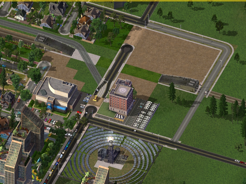
Here is the completed terminal station for the Red Line. A looping roadway and park-and-ride garage were constructed to facilitate access (facing west).

This is a stretch of 33rd with the median running complete, through the industrial area between Progress and Ashcroft (facing west).

And finally, here's the stretch right at the Ashcroft and 33rd intersection, just before the terminus (facing east).

That does it for this update of Tarkusian Cities, and for the current work on Chemeketa's first major transit project--hope you enjoyed it. Next up will be some new road work in Chemeketa, and perhaps even a few "lost" updates from other regions, rescued from the "Tarkives".
-Tarkus
Having a small bit of downtime at the moment, I'm going to sneak out a few updates of Tarkusian Cities for the first time in over a year. In this update, at long last, we will see the completion of the northern segment of the Chemeketa Red Line Light Rail, up to its terminus in the Lila Engel/Starpoint neighborhood.
First off, long overdue replies:
On 6/17/2017 at 9:32 PM, raynev1 said:Since I used to do road work , that is a good part of what makes me enjoy your CJ . And how you explain what's going on , I like it .

Thanks for the very kind words--given that you've done road work, I take that as quite the compliment!
On 6/18/2017 at 6:24 AM, kschmidt said:Last picture power may have no use or can be replaced by PEG Conduit or obsolete !
Sincerely yours,
kschmidt
Thanks for the suggestion! I agree that lonesome power pole is a bit awkward. I'm probably going to be redoing that freeway at some point down the line, so that gap will probably go away in some fashion.
And without further ado, here's Update 105.
First off, here's a map of the area around which this project is centered.
The red line with the squares is the routing that the light rail line will take through the area. After following the existing heavy rail line north of downtown Chemeketa, the Red Line will curve onto 33rd Avenue NE running down the median until just before the 5-leg roundabout, where 33rd meets McCabe Street, Creek Drive, and Starpoint Drive.
The most challenging bit of this project will be the stretch where the Red Line crosses the rail line and begins its median running portion on 33rd. Here's the existing conditions at this part of the project (facing west). (Also, the rail crossing here looks a little funny--this image actually dates back to a very, very early prototype of the RRW plugin.)
In order to facilitate through traffic to the residential neighborhood to the west, abutting the Chemeketa Parkway (Highway 215), as well as future work on 33rd, an extension of 34th Avenue was built to the north, connecting up with Bobcat Drive NE. The project study determined that the most effective method of handling the rail crossover was to trench it below, allowing the Red Line and 33rd Avenue to cross overhead (facing west).
A little further along with construction (facing west).
The stretch of 33rd east of Bobcat has now been closed off for reconstruction (facing west).
This is part way through the reconstruction of the segment from Bobcat to Progress (facing west).
The stretch up to and beyond Progress Street is now completed, along with some re-development and the construction of a new park-and-ride garage (facing west).
Preparations are underway for the northern terminus of the Red Line. The road coming in from the top of this image is 33rd Avenue, and the line will terminate in the graded area behind the office buildings, making a northward jog before the roundabout (facing west).
Here is the completed terminal station for the Red Line. A looping roadway and park-and-ride garage were constructed to facilitate access (facing west).
This is a stretch of 33rd with the median running complete, through the industrial area between Progress and Ashcroft (facing west).
And finally, here's the stretch right at the Ashcroft and 33rd intersection, just before the terminus (facing east).
That does it for this update of Tarkusian Cities, and for the current work on Chemeketa's first major transit project--hope you enjoyed it. Next up will be some new road work in Chemeketa, and perhaps even a few "lost" updates from other regions, rescued from the "Tarkives".
-Tarkus
-
 16
16
-
 1
1


3 Comments
Recommended Comments
Sign In or register to comment...
To comment in reply, you must be a community member
Sign In
Already have an account? Sign in here.
Sign In NowCreate an Account
Sign up to join our friendly community. It's easy!
Register a New Account