


Intro: Description and History

Note: This is my first Journal, and is my first time playing SC4. These first couple of entries are very amateur, but since they give good background history I will keep them around (it's also nice to have a record of how far I have come since I started).
To Skip ahead to the beginning of the Chapter One Storyline, go to Entry 6 ( Solace Bay 1902) .
To skip ahead to where I begin using more custom content and trying to improve my CJ skills skip ahead to Entry 14 ( Reader's Guide to the Solace Bay Region) This is a good entry to start with anyway, because it is a sort of an overview of all the characters and plotlines. Thanks for stopping by.
Eldaldo
Disclaimer/props
This City journal is really more of a Country journal, which looking through the site is quite common, but I love thinking about pioneers and things so I am starting with wilderness (mostly), and developing the regions of my country and how they interact with each other. The scale of this is also massive, to the point where I doubt I will finish, But I am planning on featuring around ten regions of the country in the journal, though really only focusing on five. I am quite inspired by the natural growth journals of csgdesign and marsh, though I am certainly not as patient or creative as they are, so I will probably not be following csg’s rules to the strictest degree. Still, Props to CSG for creating a genre of play, and props to Marsh for having a really good journal too. I made up this continent, but used maps that are mostly real places, also I use some names from cities and places that I like and even build them in a similar way (Duluth for example). I realize that this is not strictly original, and you will recognize many maps and names of my cities, I hope that doesn’t annoy you. In the end, it is my CJ.
Description
This Journal will watch the development of the Country of Inakaye, from the late 1800’s until present. Inakaye is a large continent somewhere between the eastern coast of Sim Nation and the ends of the world. It is estimated to be slightly larger than Australia. It is quite north; to the point where its northern reaches disappear into ice and glaciers. Yet much of it has a growing season and climate suitable for the cultivation of many types of crops. Inakaye is teeming with wildlife, but had no Indigenous peoples prior to the founding of it’s first settlement, Auen. It is covered in mostly conifer forests, and deciduous trees are mostly imported. It is a very mountainous region. As you can see below it is Quite breathtaking
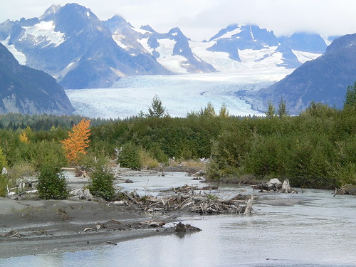
Modern geologists describe it as the meeting of three landmasses all driven into one another. This produces the t shaped central mountain range. The northern landmass is ancient and has a large inland sea named GreatLakeAudra. The southern two landmasses are mostly mountains with dangerous cliffs and reefs lining the coast, making them hard to colonize and hard to explore. Therefore most settlements were made in the north.
History
The Continent was discovered in 1783 by Ian Mackaye. A man who was always pushing the boundaries of conventional exploration, he and his crew thought they were dead for certain after sailing east from sim nation for six weeks without sight of land. They had nearly run out of provisions when they spotted Inakaye. Here is an artist's rendition of Him and His Crew in the throes of huner and anguish prior to the sighting of Inakaye . . .

Ian originally wanted to call it Eastland (kind of a boring name from such an original guy, right?), which stuck around to some degree, but most people ended up calling it Inakaye; which was just a slurring together of Ian’s name. When the first settlers arrived and claimed the continent as their own they named it Inakaye officially.
Settlement of Inakaye was slow, It was a very long and perilous journey. And the land itself was devoid of human life and full of dangerous predators like bears, wolves, man eating raccoons, and deadly lolcats. The first group of settlers was led by Paidrig Cassidy, who brought his family and four ships full of simnation’s poor and destitute to try and make a new life for themselves. They settled in the first river delta they found which they named The Allegheny River after the town which Paidrig was born in. Their settlement was named Auen (pronounced aw-wen) after Paidrig’s youngest daughter. The settlement was betset with difficulty for the first few years. This entry from paidrig’s journal shows a glimpse of their hardship.
“we hasth given the earth our croppes yet she dosth not bear them for us. Furtherwithe we fight off the wilde beasts that without ceasing attaketh our modest herd of livestock. O how colde the wind bloweth in this season of autumn. I hope with all my strength we mayest survive the onset of winter.”
Yet, through all their doubts and troubles, the settlement of Auen prevailed in taming a small piece of the Inakaye wilderness and were able to send a ship back to simnation to trade for more supplies. Indeed, it was thought in simnation that the settlers had perished, for they had not been heard from for two years. But once their success had reached the ears of simnation, it gave ideas of a fresh start to more and more people, and thus more people started immigrating. It was quite a slow trickle though due to the long voyage without any intermittent stops. Even once steam ships were invented, it was too long a voyage to make without refueling, and wind was still the only way there. To Inakaye’s fortune though, in 1866, a small island was discovered halfway between simnation and inakaye and at a latitude south of Auen. The Auen Government (then the only government of Inakaye), immediately claimed the island as a territory of inakaye, and Roger’s Island became a refueling point and made trade between Sim Nation and Inakaye possible. Once steam travel to Inakaye became possible The population exploded as many people moved to this new land to start over, escape sim world conflicts, or take advantage of Inakaye’s many resources. Many Sim world governments wished that they had laid claim to the continent that they had originally determined to be too far away to be useful for anything. Yet, with close to 200,000 inhabitants, inakaye was not something that could just be grabbed hold of without a fight that would require great effort and resources. In addition the rest of the sim world was involved in its own turmoil, thus, Most Sim governments continued to focus on their immediate concerns and Inakaye remained free to prosper as a distant entity.
By the late 1800’s There were only two cities in the country. Auen, was the largest at around 160,000 sims. The other was Duluth, at the western edge of GreatLakeAudra, it was a confluence of commercial and industrial trade routes, with coal to the south and east, Mineral rich hills to the north and east, and fur and lumber trade by water from the surrounding area, it formed a nexus of travel and industry throughout the region. It was also the birthplace of the Inakaye railroad, which was originally used to bridge the small stretch of land between the Prairie and Allegheny rivers, and eventually allowed the transport of all the industrial resources/commercial goods from in and around Duluth through the Allegheny river valley to Auen, and then off to Simnation and the rest of the world. Duluth has about 100,000 sims making it the second most populous city in the country, yet it is quite a different city from Auen. Where Auen has plenty of culture and education, Duluth is almost devoid of such things, and remains almost entirely low wealth industrial. In many ways it is still a frontier town though so many people have moved there. With the advent of the rail connection to auen though, it is only a matter of time before wealth, education, and culture make their way to Duluth.
Unfortunately little in way of records of the development of these two towns has survived, but experts believe that the early development of Auen looked something like this,

whereas Duluth probably looked more like this.

Lastly, Below is a crude map of the continent as of 1884 made by Inakaye’s premier cartographer Count Jaques le Duceaux. (map is very general, not entirely to scale, but kind of to scale).

That's it for now, more to come later . . .


4 Comments
Recommended Comments
Sign In or register to comment...
To comment in reply, you must be a community member
Sign In
Already have an account? Sign in here.
Sign In NowCreate an Account
Sign up to join our friendly community. It's easy!
Register a New Account