



Digging Deep: Line 1 overview

Reading time: 30 minutes to 1 hour, depending.
Today we start a new series, dedicated to a thorough analysis of each of the subway lines in Isla Bonita. As it's a long series and some subway lines are still being built, this will be a non-periodic special issue, but expect more in the future. We'll start with a pioneering line: the oldest proper subway line, the longest line and, some would say, the most panoramic: Line 1.

Line 1
Length: 24.20 kilometres (15 miles)
Number of stations: 46 across 5 cities
Colour: commie red

History
Lines 1, 2 and 3 were part of the "Million-sim plan", a comprehensive transportation project undertaken by the Isla Bonita government when the population of the island grew over 1,000,000. The plan, built with guidance from the Soviet Union, called for infrastructure upgrades and new tunnels to form a triangle network centred around Anclaje, which was the largest city back then (since surpassed by Interior and Cuerno de Águila) and arguably still features centrally in the metropolitan area. While Line 2 headed north to Interior, and Line 3 was built towards the northwest, eventually making its way to Bahía Herradura, Line 1 crossed Anclaje from the west to the northeast, an alignment it keeps to this day.

The 'Soviet triangle' in downtown Anclaje, with Line 1 (top to bottom), Line 2 (left to right, bottom half of the screen, including viaduct line) and Line 3 (in faint white, then yellow, extending from left to right at centre-top)
Another tenet of Soviet-style subways, deep-bore tunnels, was only partly carried out —Isla Bonita's volcanic geography and shallow, waterlogged soils don't lend themselves to deep tunnels, so parts of Line 1, particularly on its eastern side, run on an above-ground viaduct instead. On the other hand, on its western approaches, substantial parts of Line 1 actually run below canals and bays, which require deep tunnels and stations. The line also has some at-grade approaches and stations, though these are a minority.
While the bay more or less impeded expansion for Lines 2 and 3 (though more on that topic on their respective deep digs), Line 1 was free to expand on both sides. Furthermore, as Bahía Medusa and Cuerno de Águila exploded in population, demand for extensions helped Line 1 grow unimpeded. Line 1, in turn, boosted residential and commercial demand in these cities, a virtuous circle that has led Line 1 to become one of the most used in the metro area, both for short and long trips. Further expansion, south into Finisterra and further east into Cabo Feliz, have finished the line in its current alignment.
Station-by-station analysis
Let's take a deep dig into all Line 1 stations, starting at the southeast (Finisterra) and finishing at Cabo Feliz.
Finisterra
Finisterra was first reached by Line 1 almost as an afterthought —the city was already connected to the rest of the metro area by rail and a surprisingly popular monorail line, and when the subway finally made its way to the city, it was through other lines, most notably Line 8. Most of Finisterra's Line 1 stations have been recently inaugurated as part of an ambitious Southern Expansion program, looking to address and remedy this shortcoming. Given the city's geography, all Line 1 stations here are underground, and some of the network's deepest stations can be found in the city.
Kilometre 0: Mall de Finisterra. Terminus Road 50, Finisterra
Interchange with Line 8, Monorail Line A, Tram Line 5

At the southernmost point of Finisterra, Mall is Line 1's terminus (as well as Line 8 and Monorail line A, which offer interchanges). It's a large multimodal interchange station with incorporated shops and stores.. Despite being a terminus, Mall is well below capacity, at around 3,500 passengers per day, half of which ride Line 1. Meudon rail station sits a few metres down Terminus Road and offers walking interchange.
Kilometre 0.25: Hotel. Costera Avenue 1

The next station, about 250 metres to the west of Mall, is Hotel. At 1,500 daily passengers, it's not a very popular station —but despite its closeness to the terminus, it sits across an artificial bay, so it's still somewhat used by Finisterreans. It serves the popular Hotel Finisterra.
Kilometre 0.7: Finisterra station. Av. Costera 450
Interchange with NorEste rail line.

Finisterra station has a long history as a terminus for the NorEste rail line, but it was recently turned into a subway station in Line 1. The subway station features two entrances: one directly into the lobby of the rail station, plus a second one across Costera Avenue. At around 700 passengers total, this is one of the least used stations in the network, particularly for an interchange station with nearby ferry connections, though it has proved mildly popular with beachgoers on day trips.
Kilometre 1.15: Subterránea Station. Calle del Riel 1
Interchange with NorEste railway, Tram Line 5

Subterránea is an underground station for NorEste trains and Tram Line 5. A new Line 1 station has recently opened, but its only entrance is to the main station lobby. The station serves 40,000 daily passengers combined, and it's considered to be over capacity.
Kilometre 1.7: Acuapuerto Station. Calle del Aeropuerto 200

A small, deep, single-entrance station, Acuapuerto only serves about 2,000 people on a regular basis, but it sits right next to the Island Air water airport. Given its surrounding geography, and since it's been built on reclaimed terrain, this is one of the deepest stations on the island, with platforms a whopping 30 metres below ground.
Kilometre 2.05: Cruceros. Cruceros Roundabout
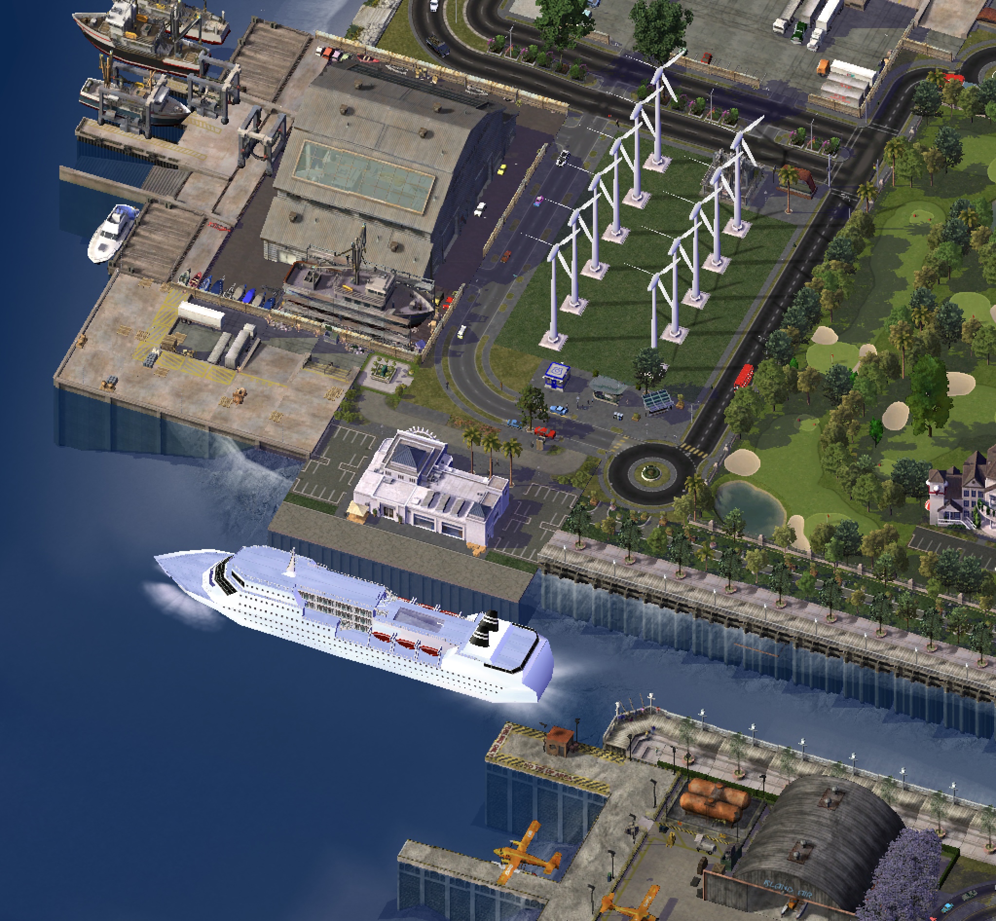
Another station serving long-distance infrastructure, at 150 daily passengers, Cruceros might be the least-used station in the network. Nevertheless, it was built to serve a hard-to-reach area of Finisterra, so it was decided to have it anyway.
Kilometre 2.75: Fragata Finisterra Station. Av. de la Fragata 650 (w/Calle Marítima)

Fragata Finisterra was the first station built under the Southern Extension program auspice, though it had actually been planned long before — its construction being delayed for administrative and budgetary reasons (as with many other stations, it's built on partly reclaimed ground, surrounded by water on three sides) for over a decade. It serves the Península entertainment area, including the Finisterra boardwalk —a car-centric area that sees some pedestrian traffic over the weekends. However, at just 700 passengers per day, this station is not well-used, perhaps proving its critics right.
Kilometre 3.4: Avenida del Parque station. Parque Avenue 250.
Walking distance from Catania train station (NorEste)

Image with west up top
Long considered Line 1's terminus, Avenida del Parque serves the Catania neighbourhood in northwest Finisterra. This densely-built residential and commercial area around the Catania train station (seen in the image, top) has long suffered from traffic problems, being as it connected to the rest of the island only by Parque Avenue (where the station sits), meeting with Highway 1, and Fragata Avenue, leading to another residential area in neighbouring Cuerno del Águila.
A popular bus connection, Avenida del Parque serves some 13,000 sims daily. Despite no longer being the only station in Line 1, it's this line's most popular station and the most popular non-interchange subway station in Finisterra.
Cuerno de Águila
Line 1 sees its greatest extension in Cuerno de Águila, where it deals with challenging geography: several short underwater segments, steep climbs and some tight curves. It draws a wide arc from southeast to northwest in the city, but while some stations see heavy use, it actually avoids many important landmarks and has few interchanges within the city, so it only sees moderate use despite having the most stations of all.
Kilometre 4.1: Unión Station. Fragata Avenue 2200
Interchange with Tram Line 4, NorEste Rail

Unión subway station is the first station coming into Cuerno del Águila, and it sits in the middle of Catania's sister development of Unión, right next to Unión train station, one of the NorEste rail termini. As Tram Line 4, a.k.a. the east coast tram also stops here (and has its depot a couple blocks away), and Unión station is also the terminus for some bus lines, it's one of the most popular stations on the line, with almost 55,000 daily passengers across all transportation modes.
The subway station has three entrances: one directly on the lobby of Unión rail, and two on opposite sides of Fragata Avenue.
Kilometre 4.45: Depot Station. De La Alcaldía 200

In this picture, south is up
Depot Station is both an engineering marvel and an oddity within the network: Line 1 reaches its shallowest point so far, so the station is actually built open to the air. On the other hand, it sits right next to the sea, with only some riprap protecting it from the elements. As such, it has been a controversial station: sea spray requires a substantial amount of maintenance, the station is not accesible, and spring tides can sometimes cut the line short out of precaution, though so far it has never been flooded. On the other hand, its 1,500 daily passengers cite the fresh sea air as one of the high points of the network.
Kilometre 5.05: Casino Station

A sister station of Depot's, 600 metres away across the shallow Casino bay, Casino station features only 50 daily passengers, though the actual number might be higher on account of fare evasion. It serves the namesake Cuerno de Águila casino, the local State Fair and a few other attractions around a commercial area.
Kilometre 5.6: Estación Isla Aeropuerto, al Aeropuerto Avenue 1200

Image looking south
When Line 1 originally made its way to the west coast of the island, one of the main justifications for what had been a difficult project was the possibility to reach Cuerno de Águila airport, the first international airport in Isla Bonita, which sat on the appropiately-named Isla del Aeropuerto (Eng. "Airport Island"). The airport sat at a difficult location, foggy and surrounded by hills —not unlike the current E. Valenti airport further north— but what doomed it was its extremely short, impossible to extend runways (Compared to EVA's over 4 kilometre runways)
The airport is long since gone, replaced by a commercial area of mixed success, judging by the empty lots right next to Isla Aeropuerto station and middling usage numbers at the station itself, despite its new entrance across al Aeropuerto avenue. Unión Pacifica rail station lies about 100 metres by foot and there have been talks of rerouting Line 1 to reach this underserved rail station, but the difficult project (deep tunnels under reclaimed, potentially polluted land) doesn't seem worth the trouble.
KIlometre 5.9: Helipuerto station. Al Aeropuerto Avenue 800

Image looking south
Instead of the old airport, Cuerno de Águila city agreed to build an express bus stop to the new airport (first Bahía Medusa, now elsewhere) and a heliport. In the decommissioned land, meanwhile, a new bus depot was built. While the heliport sees a fair amount of use, most people arrive by bus —Helipuerto station only has about 250 daily passengers.
Kilometre 6.4: Vulcán station, al Aeropuerto Avenue 450

Looking north. The entrance (next to the park) is hidden behind some palm trees
The old Line 1 tunnel ran directly under the airport on a long, uninterrupted stretch. Even after its decommissioning, technical difficulties made it extremely difficult to build a station here —a hot spring nearby risked scalding workers, and the area wasn't so densely populated to merit a station. The hot spring was eventually allowed to flow free, which reduced water pressure —but not enough to stop it from flowing into the tunnel.
As reworks were to be needed anyway, it was decided to reroute Line 1 some 50 metres away from the hot water spring and build Vulcán station, named after the Roman god, in this underserved area. About 400 daily passengers grace this station.
Kilometre 6.85: Hotel de la Colina, Hotel Square
Interchange with Tram Line 4

Looking south on top
In between Vulcán and Hotel de la Colina lies the first big curve of Line 1, turning east as it starts climbing up the aforementioned hill (the meaning of the word "Colina"). Despite this, Hotel de la Colina, named after a since demolished hotel that stood in that place, lies in the low ground next to the beach. The station started its life as a Line 1 station before becoming the terminus for the then Coast Tram (a name that repeats itself over the island). With the extension and takeover of the tram line by Tram Line 4, the station was remodeled and moved slightly to the north, to its current configuration facing a small square.
Hotel de la Colina, as it befits an interchange station, is fairly popular, with 15,000 daily commuters using it to ride its combined services.
Kilometre 7.35: Subida Chile, Subida Chile 300

Subida Chile is a new station built in a mostly low-density residential neighbourhood. It's a fairly deep station as the tunnel underneath climbs the Cuerno de Águila hill in this sector.
As the station is new, only about 150 daily passengers have been counted.
Kilometre 7.8: Valle Súbito, Calle Súbita 1300

West is up in this picture
One of the most iconic stations in the Line 1 uphill extension, Valle Súbito's Line 1 station (not to be confused with Line 8's Valle Súbito on nearby Dorsal Avenue) lies on the Dorsal Loop: a complex connector between the two lines that formerly enabled branch services, but is now mostly used for maintenance purposes. Line 1 here turns north for a little bit, so the station is oriented north-south. Its only French-inspired entrance lies on a small cove, next to some stairs, and is at some depth underground, which has led to accessibility complaints on account of the sheer number of steps. Maybe it's for this reason that the station is lightly frequented, with only about 200 daily passengers (compare to almost 3,000 for Line 8's namesake)
Kilometre 8.3: Foch station, Dorsal Avenue 800
Interchange with Line 8. Tram Line 4 stops nearby.

The first proper interchange station in Cuerno de Águila, in here Line 1 intersects with Line 8. As such, and since it serves Cuerno de Águila stadium (a rugby/football multipurpose arena), the station is fairly spacious and sees about 3,000 daily commuters down its halls. This is also where Line 1 once again turns east, an alignment it will then broadly keep for most of its remaining track.
Kilometre 9.1: Monumento station. Plaza del Alcalde Colosal.

For a while, Monumento —at the foothill of Cuerno de Águila— was the terminus of both Line 1 and Tram Line 4, serving a dense residential area in the valley. Its significance diminished somewhat as the subway line first, then the tram line were both extended westwards —in the tram's case, this meant no longer calling at the station. It now survives as a fairly popular subway station, with over 4,000 commuters using it daily —no doubt helped by its relative distance to other subway stations.
Kilometre 9.5: Valle de Anclaje station, Valle 100
Interchange with Tram Line 5

Valle sits on the inland valley of Cuerno de Águila, on Valle avenue, which splits residential and commercial areas in the city. It's a relatively shallow station, owing to the geography of the place, and it offers interchange with Tram Line 5. At over 42,000 daily commuters, it's one of the busiest nodes in the entire Isla Bonita network.
Kilometre 10.15: San Pablo station, Saint Paul's Avenue 1900

Photo looking south
Saint Paul's Avenue is a new avenue that was opened from Saint Paul's Church to the west. As part of the expropriation works, Line 1 was rerouted from under a rail tunnel (part of the NorEste network) slightly to the north, and San Pablo station was built. It connects to the national rugby stadium, so it sees use mostly during weekends and match days —other than that, it only averages about 1,000 daily commuters.
Kilometre 10.5: Cerro Anclaje. Subida Argentina 1700
Interchange with NorEste rail

Line 1 mostly shadows NorEste rail in this section, so it combines with it in Cerro Anclaje, which —despite its name— is still located in Cuerno de Águila. Anclaje can be seen from its tower clock, nevertheless.
Line 1 platforms are below ground, and while Cerro Anclaje is a multimodal hub with over 20,000 daily commuters, most of them are actually riding the rail (on an above-ground platform) or taking the bus at either avenue. The station serves a commercial and touristic area, which explains its traffic.
Kilometre 10.85: Iglesia station. Saint Paul Lateral 1600

Iglesia is a new station at the foot of Saint Paul's Church, with scenic views of the bay below. That being said, it serves a low-density neighbourhood and features very little use. A must-visit for tourists.
Kilometre 11.3: Anclaje Oeste station. 13 Oeste 100

Anclaje Oeste (meaning "West") was the first subway station in Cuerno de Águila, even if it's less than 100 metres from the city limits. It's a single-entrance station with less than 400 daily commuters using it. A must-miss for tourists.
Anclaje
Anclaje is where the line broke ground, and it traverses the city from west to northeast, following under or parallel to two of the city's main avenues for most of its length.
Kilometre 11.5: Campo eléctrico. 1 Norte 1200-1100

The first station in Anclaje, Campo eléctrico (so named after a nearby transmission station) currently sits among empty lots. Nevertheless, it has two entrances at the two ends of its platforms and about 2,500 passengers use this station, almost all of them to combine with a bus.
Kilometre 12: Pueblo Viejo, 1 Norte 800-900
Interchange with Line 4, NorEste Rail

"Pueblo Viejo", meaning "Old Town" is the oldest residential area in Anclaje, so it stood to reason it would get one of the first subway stations. The construction of Line 4's platforms led to a sprawling underground structure where two subway lines, one rail line and several buses intersect.
The station has three different entrances: a small, new entrance at 1 Norte 900 (next to the church-museum), the main Line 1 entrance at the 1 Norte roundabout, and an extra entrance leading into Pueblo Viejo rail station. Over 17,000 people use this station, an unsurprising amount given the high density neighbourhood it serves.
Kilometre 12.65: Centro Decó, Gran Avenida 500

South is up in this picture
As part of the Anclaje Renewal project, a commercial state-led development caused a realignment of Line 1 and the opening of Centro Decó station, about a block away from the old station. As this station serves a large commercial complex, about 5,000 daily commuters use it, making it a fairly popular station (particularly since it has no interchanges).
Kilometre 13.15: Plaza de Alabastro, Gran Avenida 200
Interchange with Line 3, NorEste rail

The main station of Anclaje, sitting right under its main square, Plaza de Alabastro is one of the most important stations in the entire network. It was among the first stations opened in the soviet-style plan, and it has been expanded and modernised a number of times since. The subway station is actually next to Keleti terminal station, and the two combined have over 70,000 daily passengers switching between rail, subway, ferry and buses. Of course, the station also serves the main financial district of the city, the courthouse, the main City Hall and the local mosque.
Kilometre 13.55: Del Río station, Bulevar Valenti 100
Interchange with Line 2

Another component of the downtown Soviet triangle, Del Río features both above- and below-ground tracks, the latter belonging to Line 1 as it approaches Anclaje river. From an engineering standpoint, it's a tricky station, with long lifts and escalators, which has probably made it less popular than its location would merit, at around 5,000 daily commuters.
Kilometre 14.1: Avenida Presidio station, Bulevar Valenti 400

One of the most controversial stations, Avenida Presidio is actually one of the newest stations. The original metro plan envisaged a 900-metre-long tunnel that went under but avoided this industrial, low-density area. Protests and petitions followed, but only after decades of fighting did the government acquiesce to build a station here.
And boy, did they! 4 entrances on all sides of Valenti Boulevard, just covering all bases. It's a massive station with Spanish solution, but it doesn't seem to warrant such overengineering… or does it? Once the use numbers drop, we'll see.
Kilometre 14.6: Convención station, Bulevar Valenti 800

Presidio's sister design, and cause for pessimism, Convención is… there. It's got three entrances to serve under 2,000 commuters. It does serve an industrial and commercial sector, but Xiangshen station nearby is much more popular.
Kilometre 15.55: Estadio station, Olímpica Avenue 1100
Interchange with Tram Line 2

West is up in this picture
Lots of things happen between Convención and the recently-renewed Estadio stations: it's one the longest stretches of uninterrupted line, at almost 1 kilometre —but Line 1 turns north at 11 Este, hops out of the (by now shallow) tunnel, and then turns northeast alongside Olímpica avenue.
Estadio station, the last located in Anclaje proper, serves a mix of residential and industrial areas, but it's so named after the nearby Anclaje Baseball stadium, a short walk away from the station. It also has underground platforms to serve Tram Line 2. It would stand to reason that this would be a busy station, but unfortunately, use records seem to have been buried in the latest remodeling. Oops!

A picture of the station before the remodeling as seen in the latest Anclaje guide, looking north
Bahía Medusa
Line 1 crosses Bahía Medusa, broadly speaking, from west to east, crossing some of the most important areas of the city. Nonetheless, its course takes a couple of interesting twists and turns, metaphorically and literally. Bahía Medusa's marshy, sandy floors also meant that Line 1 was built entirely above-ground (or at-level in some short sections, more on that later).
Given that it's the main link across town, Bahía Medusa sees the heaviest usage over Line 1.
Kilometre 16.75: Estación de la Bahía, Bulevar de la Bahía 700

West is also up in this picture
The actual longest stretch of uninterrupted track (tied with a rural one later) goes from Estadio station, across the city border, and finishes in De la Bahía station. This station sits at a very important node in western Bahía Medusa: right at the end of Olímpica Avenue (which Line 1 shadows almost along its entire 2-kilometre length, but only has one station on) where it meets Bay Boulevard (formerly avenue), so named after the shallow bay immediately due east. Also along this node traverses the second HSR line, though it doesn't stop here, unlike local buses.
The actual station is built straddling a busy intersection: the first stretch of rail-over-road —a space-saving necessity here, where the soil was considered too difficult to excavate— happens here, so the line actually runs above 7 North road and the platforms form an arch right along a narrowing of Bay Boulevard, with the south platform enjoying a panoramic view of the boulevard down to the open sea.

A view from the South reveals some intricate details about the station
Despite the distance from the former station and its importance, De La Bahía only sees medium usage, with about 5,000 passengers across all means of transportation.
Kilometre 17.25: Bahía Medusa, Avenida Atajo 250
Interchange with Line 4, Tram Line 1, Rail and HSR

One of Line 1's only two at-grade stops is the 10-platform Bahía Medusa station, a massive transit hub that has been the lynchpin of Bahía Medusa (the town) pretty much since its foundation and has gone through many iterations. The latest one, built for high-speed trains, features 6 platforms for slow and fast trains, while Line 1 stops at platforms 7 and 8. Some rarely-used switches enable Line 1 trains to stop on Platforms 9 and 10, usually reserved from Tram Line 1, and then continue onwards along that line to the soon-to-be-decommissioned Bahía airport, an alternative that was explored during its construction but ultimately discarded in favour of monorail.
Besides the tram and rail, Bahía Medusa is also a stop in Line 4, which tunnels below ground (in what was consider a major technical breakthrough) and stops in platforms 11 and 12.
Bahía Medusa station sees about 20,000 daily passengers —good numbers, though the station still sits under capacity. It is expected that new commercial development in the area will finally allow the station to reach its full potential.
Kilometre 18: Bulevar al Este station, Bulevar al Este lateral road 1200
Interchange with Tram Line T3

Right after Bahía Medusa station, Line 1 takes a sharp turn north, crosses a highway through some extra-elevated track, then finally reaches Bulevar al Este, arguably the main boulevard in Bahía Medusa, heading —as the name implies— east from Anclaje into the furthest reaches of the island. Bulevar al Este (the station) sits across the main boulevard, on what's actually an extension of the side gardens formed by the opening and curving of the lateral road away from the main avenue. As such, it's a station built with plenty of space and features an underground garage and bus parking.
The neighbourhood where the station sits at is one of contrasts: here stand some of the few high-rise office buildings allowed in Bahía Medusa, but the residential Casas Blancas neighbourhood of single-family housing lies just across 12 Norte; the local stock market stands here, but both the University of Bahía Medusa and its associated theatre are located just a couple blocks down the road. As such, the station has to deal with plenty of traffic throughout the day, but thanks to its wide platforms and stairs, at 13,000 daily riders, it could even be considered slightly underused.
The only interchange possible is the Bulevar al Este stop on the Tram Line 3, which —for the most part— rides along the median of its namesake boulevard. It's a walking connection, so passengers actually need to leave the station —and the tram stop, at 23,000 daily users, is actually the better used of the two. Go figure.
Kilometre 18.50: Plaza Madre station. Avenida Madre 50
Interchange with Line 5

As Line 1 turns northeast, it reaches Plaza Madre. Plaza Madre station continues the trend of large, elevated stations. This one overlooks its namesake Plaza Madre and it's a bit of a cultural hub, with the theatre to the south, the opera house a couple blocks to the north, and both the zoo and the local movie studio a brisk walk away.

Yellow markers for a 5-minute and 10-minute walk. The theatre and opera fall in the former category, while the zoo is at the latter and the movie studio sits just out of reach
Plaza Madre station has an interchange with Line 5, which uses underground platforms and also has entrances of its own. The two lines combined see about 16,000 daily passengers riding them through this station.
Kilometre 19.15: Haussmann station, Piedmont Avenue 1800

In this picture, west is up
After continuing some more to the northeast, Line 1 turns east and starts running over Piedmont avenue, which in turn is a continuation of De la Bahía avenue after it turns sharply to the east. Haussmann is the first of four stations in Bahía Medusa that are identically designed, and while it's named after Georges-Eugene Haussmann —famous for his redesign of Paris—, neither the station nor the surrounding area are fully faithful to the Baron's teachings.
The station can be instead described as a tall glass monolith with incorporated bus stops, originally built with a view of nearby Haussmann park, but now surrounded by some barely-up-to-code residential towers. The surrounding area also has a commercial neighbourhood to the north, and, all things considered, its 16,000 daily passengers are a good number for what's essentially not a very important station.
Kilometre 19.70: Alturas station, Piedmont avenue 2200
Interchange with Monorail Line B, rail

North is up in this picture
Alturas's tracks and platforms stand 30 metres over the ground, which is what gives this station its name (meaning "Heights"). It was necessary to build Line 1 to such heights to account for the passage of the already elevated Monorail Line B, as well as the nearby elevated Highway 5, plus (below-ground) rail.
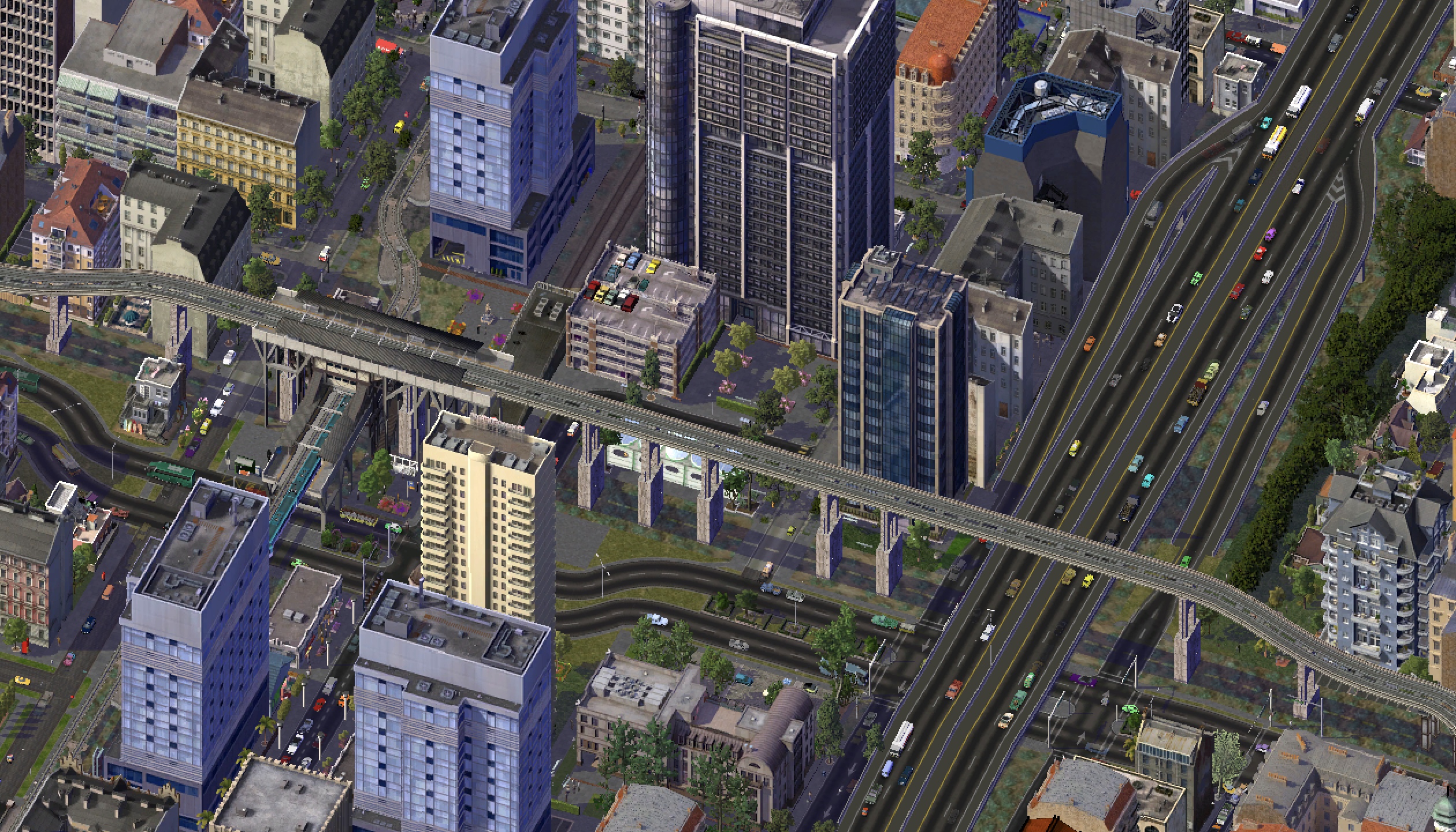
A wide panoramic of all the transportation means converging on the area. The rail has since been completely covered.
Alturas serves about 25,000 daily passengers, some of whom are changing transportation modes, but also many commuters from and to the local area, which includes office buildings and residential apartments.
Kilometre 20.05: Brigham Young station, Piedmont Avenue 2850

The station and its surrounding area at night, with north on top
Brigham Young station, named after the Mormon leader, was given this name as it was built close to the local Mormon temple. It was built in the same modern MTA design as other stations in the line, and this station likewise serves a mix of residential and commercial areas. Notably, though, it also serves an important civic hub in eastern Bahía Medusa: the Superior Hospital (with ambulance service), the Peace and Church and Central schools (magnet schools for the area), the Main Library and the Zeughaus museum all sit within sight of the station, while the former Royal Palace is three blocks away and the Bahía Medusa (Catholic) cathedral is next to it. For these reasons, the station is quite busy, at almost 20,000 daily passengers moving through its gates all day.
Kilometre 20.40: Palacio Real station, Piedmont Avenue 3100

Palacio Real station (top left) and its surrounding area, including the Royal Palace, the Zeughaus and some platforms of Brigham Young at the extreme far left
Just two blocks down the line (but officially 350 metres away, counting from the centre of each station) stand the platforms of Palacio Real station, easily visible from Brigham Young station (and viceversa). It's another station serving essentially the same area —but while it might seen redundant, its 26,000 daily passengers seem to find value in this station regardless.
Kilometre 21: Más Lejos station, Piedmont Avenue 3500

Más Lejos (meaning "further away) station was, for a long time, the easternmost and final station in Line 1. It remains the furthest station within Bahía Medusa, and in a sense, it stands where the city abruptly ends —multi-story buildings giving way to farmland on account of land usage restrictions and lack of demand for land here.
It's another MTA-styled station and it serves, besides the aforementioned farm, some mixed-use areas. There's a large church and square nearby, too. Maybe on account of its location, the possibility to connect with buses and the nearby electric car recharge station, the station is amongst the most used in the entire line, with 33,000 daily passengers —the largest daily use of a non-interchange station.
Cabo Feliz
The final town in Line 1's trajectory, the line here goes through some actual rural areas and makes its way to the easternmost exurb of the South Bay area. Traffic here might not be as heavy, but some of the most important landmarks of the line lie in this town.
Kilometre 21.8: Almendra Station, Piedmont Avenue 4100
Interchange with Tram Line 3

Early morning picture with north up top
The final station in Piedmont Avenue, and arguably the final station in the South Bay urbanised area, Almendra sits at the intersection with Al Este Boulevard, which uncharacteristically turns north to meet the station. Almendra is another important station, particularly as it offers interchange with Tram Line 3 —which finishes here and has an at-level stop nearby—, but it sees slightly less use than other stations in the area, at only around 21,000 daily passengers. However, as much of the area around it is farms, its use is expected to rise as the city continues growing east.
Kilometre 23: Pistacho Station, Pistacho roundabout, Cabo Avenue 0
Interchange with HSR and Docklands rail
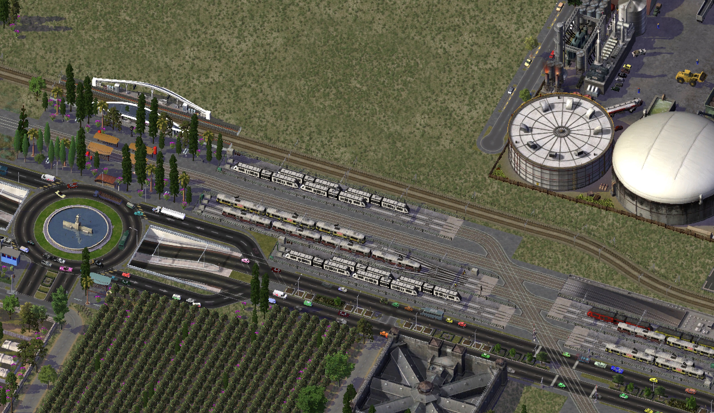
Work is being done to straighten out the line here.
The longest stretch of uninterrupted line (tied with the stretch between Anclaje and Bahía Medusa) happens here, between Almendra and Pistacho stations. The line actually traverses a completely rural area as elevated rail —a stretch that, despite its heavy usage, calls for no station.
Pistacho station, the only other at-level station in the line, stands at the entrance of Cabo Feliz, on a mostly rural area, facing the entrance roundabout of the town. It is, despite its remote location, a fairly busy station, with some 19,000 passengers alighting or disembarking here, many of them military travelling to and fro the military base across the roundabout (which can barely be seen across the picture) or the Federal Jail down Main Avenue.
The station is also notable for its many docking bays, where unused trains are stored and can start and finish their journey.
Kilometre 23.50: Talleres station, Cabo Avenue 300

The final stretch of Line 1 digs underground after Pistacho station, under the sandy, waterlogged soils of Cabo Feliz —no small technical feat, only achievable with modern equipment—, following Cabo Avenue on its eastward direction. Talleres station is the first station here: a simple 2-platform underground station, built mostly to serve the Line 1 workshop ("Talleres" meaning just that) next door. The station sees some 8,000 passengers, mostly people switching here to buses that go along the nearby highway, but the station also serves the local residential area.
Kilometre 23.80: Avenida Cabo station, Cabo Avenue 500

At the intersection of Cabo and Main lies Cabo Avenue station, another underground stop in the small town serving a purely residential area. The main contrast here is between the tall towers to the north and the light housing built south, on potentially floodable sands.
Like Talleres before, the station has a single entrance on the south, leading to a mezzanine and then the platforms below. Some talk has been had about adding accessibility, but nothing has come out of it yet. 12,000 passengers use this station daily, though those numbers also count people taking a bus at street level.
Kilometre 24.20: Columbia Station, Cabo Avenue 750
Interchange with Docklands rail

The final station in Line 1 is also the terminus for the (regular-speed) Docklands trains, features a small bus terminal and has ferry services some 200 metres to the south. Columbia station, a veritable transit hub in the Art Déco style and twin sister to Columbia station in Cuerno de Águila, sits right next to the ocean and has six train platforms at level, plus two subway platforms below ground, and serves Cabo Feliz.
The subway station actually has entrances of its own on Cabo Avenue, but it can also be accessed via the rail station. All in all, some 26,000 passengers use Columbia station across all transportation modes.
***
Phew! This actually took me like a whole months to write, believe it or not. Granted —I went on holiday in the meantime and I've had other priorities, but still, it feels like a titanic effort. I will now show this to my psychiatrist so they can finally place me on the spectrum. Enjoy!
-
 7
7


1 Comment
Recommended Comments
Sign In or register to comment...
To comment in reply, you must be a community member
Sign In
Already have an account? Sign in here.
Sign In NowCreate an Account
Sign up to join our friendly community. It's easy!
Register a New Account