



Anclaje, part 1: general information (2nd edition)

Isla Bonita Travel Guide, 2nd Edition, 200th anniversary special!
This time around, instead of showcasing a new city, I thought it would be fun to compare Anclaje's progress as it turns 200 years old. For those who don't remember, Anclaje (/aŋ'klaxe/) is the cultural and economical (but not geographical or political) center of Isla Bonita, and the anchor city (pun intended) of the South Bay metro area. The city of Anclaje offers a vibrant cultural environment, a rich history, and stunning views to be enjoyed.

Anclaje in the past, at night

Anclaje today. Rough composite image that includes its neighbours — coastal fog obscures different neighbourhoods at different times of the day
General information
City name: Anclaje
Date of foundation: I want to say 200 years ago?
Population: 600,000 (up from 450,000)
Size: 16 sq km.
Land area: Around 85%?
Average income: 20k/person/year (down from 40k/p/y)
History
It's hard to know when Anclaje (Spanish for "Anchorage") was first founded. The South Bay, on whose shores it stands, has long been known as an excellent harbour and port of call, and Anclaje had the added benefit of nearby water springs. It was probably founded by Arab, possibly Mudéjar traders somewhere around the 17th century, but it was probably just a trading post until it was granted a City Charter 200 years ago. Due to its founders' influence, the city still retains, nominally, a majority Muslim population, even while it became a hub of liberalism in Isla Bonita. The Government of Isla Bonita has refused to ask for people's religious affiliation for the last few years, so information remains scarce.
Despite being Isla Bonita's largest and richest city until recently, and its most important port of imports, Anclaje had been repeteadly snubbed by the Bonitos, the ruling dynasty of Isla Bonita, who had set up their capital in nearby Interior and their royal residence in Bahía Medusa, an Anclaje suburb. Anclajeans were resentful of this, which eventually worked as a catalyst for the Light Blue revolution that deposed the monarchy and inaugurated a republic. While the republic still has its capital in Interior, Anclaje got a series of concessions which enabled it to reach its zenith.
From that point, however, the city has seen cycles of boom and bust. It was, until recently, the main port and gateway to the sea, and it has retained its central location within the South Bay area. But each boom cycle pushed workers to the area, which in turn, drove up property prices and pushed the wealther locals to the suburbs. This, in turn, created decay in downtown areas. The city stands now at a strange location: far from its heyday around the years 30-40, where the average resident wealth hovered over 60k simoleons/year, yet having reached and surpassed its earlier population peak and with healthy coffers to fund infrastructure projects.
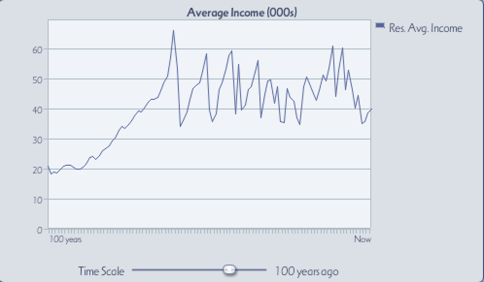

These two 100-year graphs reveal the extent of the city's volatile economy, which combined with its European architecture and Spanish language, has led to it gaining the nickname of "The Buenos Aires of the Seas"
Geography
Anclaje is anchored (haha, see what I did there?) between the South Bay to its south and the Coastal Range to the north. The coastal plain on which Anclaje is located is very narrow, no more than 2 kms from the shore, and can be roughly bisected by the Cerro Presidio ("Jail Hill", so named after its Californian counterpart), which juts from the Coastal Range almost to the coast.
The city itself is mostly flat, with a low-lying coastal plain and salt marshes near the coast. The Anclaje River's mouth was at Anclaje Bay, a small inlet, currently right next to Main Square, which enabled ships to come near the shore. Several decades of infilling have pushed the seashore several hundred meters back and deepened the main sea accesses, but Anclaje Bay still functions as the main harbor for ferries heading all over the island.

Anclaje Bay and the Old Town, "before" photo. Anclaje Keleti is to the northeast, right next to Main Square and Plaza de Alabastro subway station, while Anclaje Docklands and Puerto monorail station is located to its east

Same location nowadays. Most of the same landmarks remain, though the Keleti basin (next to the train station) has now been opened to the air
Heading north, the Coastal Range rises abruptly, and the city extends over Planalto Hill and into El Salto ("The Jump"), a deep valley that has historically served to connect the city with its interior. The valleys were first to be settled, but the city has slowly grown into the hills, fueling demand for close-by single-family housing.
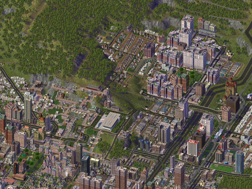
Planalto and El Salto, before. Collectively known as the Uptown, these were the newest parts of the city back in the First Edition, and were served by Estación de la Cima station

In the Second Edition, we can see how city growth has extended over the hills, taking over former woodland. High Street Station still stands, but is now surrounded by single-family housing
Presidio Hill, so named after an old jail set up by the old regime, currently a museum, has been kept as an urban park, inspired by Santiago de Chile's Met Park/San Cristóbal Hill. Besides the old jail (and the new one at its feet), Presidio Hill also has the City Zoo, the Water Park and the Opera House. It has also come to house the main power district, which has somewhat detracted from its role as nature reserve —a problem compounded by the city decision to stop watering the dense forests in the hill. Nevertheless, it remains a local attraction, especially its first and third sections.

Presidio Hill, Isla Bonita's largest urban park, during the First Edition. The Park spur of tram line T4 serves it

The same area today. The industrial area at the hillfoot is one of the foggiest areas in the entire city. Presidio Park has been exquisitely landscaped, but the rest of the hill remains in a more-or-less wild state
Finally, Anclaje has the only natural water course in the island, in the form of the Anclaje River. The river, little more than a creek, was covered during the 19th century due to its pollution, but the cleaning up efforts have allowed authorities to uncover it and allow it to run for a small stretch. The river no longer ends in Anclaje Bay, however, due to the silting that would cause.

Anclaje River nowadays, a residential area with a short boardwalk
Transportation
As the economic center of Isla Bonita, Anclaje is also the main transportation hub of the island. It has its own airport to the west, although Bahía Medusa's Looking For Sponsor International is far more used. The city is also the hub from where all rail lines spread, as well as the Anclaje & Interior subway.
Rail
Anclaje is the starting point of both the Anclaje Northeast and Anclaje Docklands rail networks, though both lines have been nationalised and there's a substantial amount of track sharing between the two. The city has 12 rail stations nowadays.

Keleti Station serves downtown, is the terminus for the Anclaje Northeast rail network, and is the busiest station in the city, with over 60,000 passengers per day
Anclaje is also the starting point of Líneas de Alta Velocidad (High-Speed Rail) 1 (serving the north and Isla Enojada) and 2 (heading east). A new station has been built to serve and connect both these lines at the industrial area beyond Presidio Hill

Estación Nuevas Rutas sits at a critical rail junction and serves HSR 1 and 2, as well as Tram Line T2. Despite this, it's on the smaller side, given its relatively remote location

Nueva Providencia was the former terminus of LAV 1 (a.k.a the NorthWest Exprés) and it's still its main gateway.
Road transportation
Anclaje has a substantial network of highways, the most important of which is Highway 3 that leads to Interior and to the north. H3 joins the city near El Salto, with 8 lanes in total (see photo above), and it used to be the only highway to reach downtown, though it was torn down to make way for a boulevard. Highway 2 crosses the city from east to west, through several tunnels and viaducts near the mountains, while Highway 1 starts at the city's southwest and serves as its western border.
Besides its highways, Anclaje also has its fair share of avenues. The two most important ones are Valenti Boulevard, which has 6 lanes and crosses the city from east to west near the coast, Boulevard Due East, which runs to the east (duh) to Bahía Medusa and beyond, Central Boulevard (former Highway 3, see above) and Cinquantenaire Boulevard, also going from east to west, a few blocks to the north.

Cinquantenaire Boulevard was inaugurated by the King on the 50th anniversary of Anclaje's city charter and occupies the former site of an elevated highway. Nowadays it has Tram line T4 running through its median. This is how it looked back in the First Edition

Cinq. Boulevard nowadays. Cinquentenaire Creek runs on its southern side nowadays, the cemetery area was redeveloped and the Main Hospital was built next to the tracks.
The city has a comprehensive bus network connected to that of other, nearby cities.
Subway and monorail
Anclaje is served by an extensive public transportation network.
Monorail line A, originally built to connect to the soon-to-be-decommissioned Bahía Medusa Intl. Airport, links the waterfront in its entirety and extends all the way to Finisterra. It's one of the most successful monorail lines in the world, with upwards of 100,000 riders per day in some sections.

Avenida del Águila station, here pictured, connects with Line 4 of the Subway and is one of the most used stations in the public transportation network
Anclaje is also the central point of the Anclaje & Interior subway, which was started in earnest once the South Bay metropolitan area reached 1 million people, with three lines built in Soviet-style.
Line 1 crosses the city from east to west, going underground below Valenti Boulevard before turning to the northeast and emerging as elevated rail right before Estadio station and continuing its way east.

The Line 1 Elevated Rail viaduct was recently redeveloped, and the newly area was acquired by the city to build a second mosque
Line 2 follows the old Interior Interurban Tram line, a north to south route. It runs at-level in El Salto, before raising to elevated rail next to Anclaje River and going underground near Puerto station, next to the Anclaje Docklands terminal.

Cerro Torre station is one of the newest stops on the line, despite the actual track pre-dating Line 2
Line 3 is entirely underground and runs from the northwest to downtown, then east along the shoreline to Bahía Medusa Intl. It has undergone several re-routings during its history —in particular, there was once an extension under the bay to Pueblo Simón, but nowadays the tunnel runs tram services. Line 3 has the peculiarity of being the only connection between the two city rail terminals.
Besides these lines, the network has expanded to include the following:
Line 4, which started as a shuttle service going from the southwest to the north, near El Salto, but has now been substantially extended. It currently starts in Cuerno de Águila, traverses Anclaje in a wide arc (serving as its circle line of sorts, avoiding the downtown area), then turns down south in Bahía Medusa, crosses the bay and serves the posh community of Providencia across the bay. It's fully underground throughout its route, and it's one of the deepest lines in areas.
Finally, Line 5, which links Interior to Bahía Medusa, has two stations, one at-level and one underground, in the extreme north-eastern corner of the city.

Most of Line 5 in Anclaje is actually at-grade and runs over the hills. Some tourists ride it solely for its scenic route.
Tram
The city has 4 tram lines.
Tram line T1 is the old Coast Tram, and follows the monorail for its entire Anclaje route, from the east up and until Xiangshen station, where it turns south and takes the underbay tunnel to Victoria station in Puerto Simón.

The old Coast Tram, dating from even before the First Editiion of this guide, used to run on the Anclaje Peninsula and to the west
Tram line T2, after some recent re-routing and redevelopment, starts and Xiangshen Station, crosses over to serve La Isla, then turns north, takes Convention Avenue, then Industry Avenue and ends near the Mormon Temple.

The newly-built Barrio Alas stands on the site of the former Anclaje Intl. airport. Barrio Alas tram station serves T1, T2, Line 3 of the subway, and it's a short distance away from the Convención monorail station.
Tram line T3, the longest in Isla Bonita, starts at Puertas station, at El Salto, and then turns to the east alongside Due East Boulevard.

Lines T2 and T3 meet at the La Legua roundabout, where Industries Avenue intersects Due East Boulevard. La Legua train station, on the Anclaje Docklands line, can be seen up north. Photo from the First Edition

The same area nowadays. Other than new tiling/pavement and terracing for the nearby rail, little has actually changed
Finally, Tram line 4 starts at Industries Avenue as a branch of T2 and heads west, crossing over Planalto Hill (and with a spur that serves the parks atop that hill) before a small underground stretch near Anclaje River and Del Valle station. T4 emerges again to serve the entirety of Cinquantenaire Avenue (see above), before dipping under La Franja rail station and continuing due west.

Despite its central location, this part of Line T4 actually serves single-family houses on the slopes of Cerro Presidio
Funiculars
As Anclaje has extended into the mountains, a concerted efforts to build slope-adapted connections has led to some new funiculars being built. From west to east:
Brighton funicular links Estación del Pabellón, on the Noreste rail line, to the Brighton Pavilion (replica, our lawyers told us we had to include the word "replica").

Cerro Catedral funicular climbs up that hill, making it close but not all the way to St. Paul's church atop.

This funicular is mostly used by locals, since it links the houses with schools. Tourists looking for a less crowded funicular to use might want to consider it as a nice destination with views over the bay
Funicular de la Cima links Estación de la Cima with the valley below. As a commercial area, this is one of the city's most used funiculars, even as it's one of the least steep climbs.

Over 3,000 daily riders use this funicular as part of their daily route
Finally, Cerro Torre has a funicular right next to the L2 subway station. It sees about 1,500 daily riders, mostly commuters looking to combine with the subway line.
And that's it! Anclaje turns 200 this month, so please join us next time, when we'll cover (and update) Anclaje's main tourist attractions for this new era!
-
 9
9


0 Comments
Recommended Comments
There are no comments to display.
Sign In or register to comment...
To comment in reply, you must be a community member
Sign In
Already have an account? Sign in here.
Sign In NowCreate an Account
Sign up to join our friendly community. It's easy!
Register a New Account