moore2cw
-
Content Count
11 -
Joined
-
Last Visited
About moore2cw
-
Rank
Freshman

-
@Linoa, agree that it should be a roadmap. Looks like a great start! @Josh6, wow! so very envious of that. Any tips and tricks as to how you made it? @Joe90, when do we get to see more from you? I always love yours!
-
Thanks! I had actually started working on the downtown in SC4, but I lost it all when my laptop crashed. Now I'm just drawing the map to what it looked like and what I would have done.
-
I've completed the major roads in my suburbs surrounding my main city of Rothbard. If you look closely you can also see a few of the Rothbard Commuter Rail lines bringing people from the surrounding area into the city.
-
Thanks. Like I said, it was my first attempt, and understood it's not to be to scale but still wanted a visual representation of the basic outlines of the routes. I think in the future I will most likely pursue something that is more akin to what you would find on a subway or at a station. My blue line actually extends over the river and to an island so there should most likely be an arrow there instead of nothing, thanks for pointing that out! You're maps are always an inspiration, please keep up the great work!
-
Hi Wiecher, This picture is very impressive How do you generate that kind of image ? Izi I used MS Paint and a colour scheme I got from a weather site, and then I just started drawing, line by line, pixel by pixel. I started with the outlines of the lowest elevations and worked my way up through the colours. PS I find it strange my post is in this thread since I am fairly certain I originally posted it in the Show us your maps thread... Some moderator moved it? Roughly how long did that map take you to make?
-
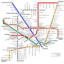
This is the map of my Downtown and Central Business District. This is my first attempt at a transit map. It's not to scale, and is more for looks.
-
@jack3oh3 Great first map. I'm still in the process of developing my first one and feel like I learn new things every day. Keep up the good work.
-
@SparkleMagic91 I've just been using Inkscape, it's a great free vector program. I know there's more than a few people in this thread who also use it (much better than I do). Check it out!
-
Thank you vivapanda. I'm going to slowly build the regions transit system. Here's what the region currently looks like. Here is a closer view of Downtown. You can see major roads, streets, and the subway system and stations.
-
Since my laptop crashed and I lost everything I've focused my effort on mapping out a new city as detailed as I possibly can. This is what I have so far. I've plotted out highways, the inner city and the location of suburbs. Bigger Image: http://img24.imageshack.us/img24/7286/rothbardz.png